- Cristóbal Island
-
Cristóbal Island Native name: Isla San Cristóbal 
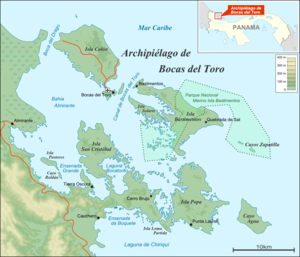
Bocas del Toro ArchipelagoGeography Coordinates 9°21′N 82°14′W / 9.35°N 82.233°WCoordinates: 9°21′N 82°14′W / 9.35°N 82.233°W Archipelago Bocas del Toro Archipelago Area 37 km2 (14.3 sq mi) Highest elevation 0 m (0 ft) Country Province Bocas del Toro District Bocas del Toro Cristóbal Island (in Spanish: Isla San Cristóbal) is a mostly deforested 37 km2 island located south of Isla Colón,[1] in the Bocas del Toro Archipelago, Panama. Laguna Bocatorito, also known as Dolphin Bay, lies on the east side of the island.
See also
References
- ^ Jisel Perilla (2008), Frommer's Panama, Frommers, p. 282, ISBN 0470371838
Islands · Bastimentos Island · Carenero Island · Cayo Agua Island · Cayos Zapatilla · Colón Island · Cristóbal Island · Popa Island · Solarte IslandProtected Areas · Isla Bastimentos National Marine ParkSettlements · Bahia Honda · Bastimentos · Boca del Drago · Bocas del Toro · Bocatorito · Carenero · Cayo Agua · Colonia Santena · Isla Tigre · Loma Partida · Old Point · Popa 1 · Popa 2 · Punta Laurel · Salt Creek · San Cristóbal, Panama · Solarte · Valle EscondidoCategories:- Caribbean islands of Panama
- Panama geography stubs
Wikimedia Foundation. 2010.

