- South Cockerington
-
Coordinates: 53°22′54″N 0°04′33″E / 53.38179500°N 0.075740218°E
South Cockerington 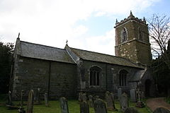
St Leonard, South Cockerington
 South Cockerington
South Cockerington shown within LincolnshirePopulation 229 (2001) OS grid reference TF381892 District East Lindsey Shire county Lincolnshire Region East Midlands Country England Sovereign state United Kingdom Post town Louth Postcode district LN11 Police Lincolnshire Fire Lincolnshire Ambulance East Midlands EU Parliament East Midlands UK Parliament Louth and Horncastle List of places: UK • England • Lincolnshire South Cockerington is a village and civil parish in the East Lindsey district of Lincolnshire, England, about 4 miles (6.4 km) east of the town of Louth.
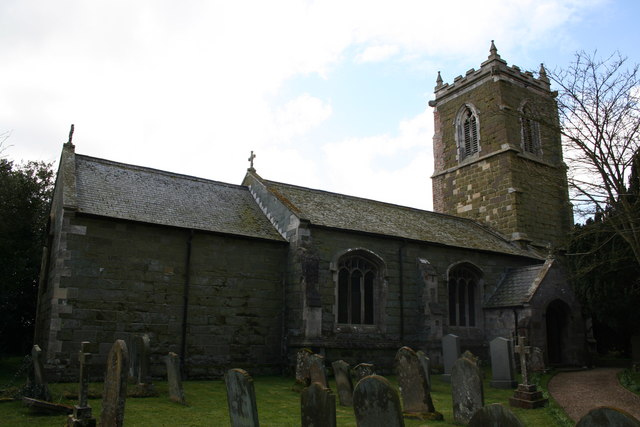
The parish church is a grade I listed building dedicated to Saint Leonard[disambiguation needed
 ] dating from the early 14th century, and restored in 1872-73. It is built from greenstone, limestone and brick. Inside there is a 15th century font, and an alabaster monument to Sir Adrian Scrope who died in 1623 which is attributed to Epiphanius Evesham.[1]
South Cockerington Hall was demolished in 1926.[2]
In the village were four almshouses which are now a grade II listed house, dating from about 1890, built of red brick.[3]
References
- ^ "St Leonards church, South Cockerington". National Heritage List for England. English Heritage. http://list.english-heritage.org.uk/resultsingle.aspx?uid=1309123. Retrieved 20 July 2011.
- ^ "Cockerington Hall". Englands Lost Country Houses. Matthew Beckett. http://lh.matthewbeckett.com/lh_complete_list.html. Retrieved 20 July 2011.
- ^ "Almshouses, South Cockerington". National Heritage List for England. English Heritage. http://list.english-heritage.org.uk/resultsingle.aspx?uid=1359974. Retrieved 20 July 2011.
External links
- "South Cockerington", Genuki.org.uk. Retrieved 27 October 2011
 Media related to South Cockerington at Wikimedia CommonsCategories:
- Villages in Lincolnshire
- Civil parishes in Lincolnshire
- East Lindsey
- Lincolnshire geography stubs

Wikimedia Foundation. 2010.