Clyde County

Clyde County
Clyde
New South Wales
Clyde NSW.PNG
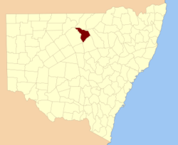
Location in New South Wales
Lands administrative divisions around Clyde
Gunderbooka Narran Finch
Cowper Clyde Leichardt
Cowper Canbelego Gregory

Clyde County is one of the 141 Cadastral divisions of the Australian state of New South Wales. It is located between the Bogan River and Barwon River in the area between them where they join. This is the area to the south of Brewarrina, as far east as the Carinda area. A very small part of the Macquarie River and Castlereagh River is also part of the boundary in the north-east.

Clyde County was named in honour of Field Marshal Sir Colin Campbell, Baron Clyde (1792-1863).[1]

Parishes within this county

A full list of parishes found within this county; their current LGA and mapping coordinates to the approximate centre of each location is as follows:

Parish LGA Coordinates
Annan Brewarrina Shire 30°30′26″S 147°02′46″E / 30.50722°S 147.04611°E / -30.50722; 147.04611 (Annan)
Back Willoi Walgett Shire 30°13′54″S 147°24′04″E / 30.23167°S 147.40111°E / -30.23167; 147.40111 (Back Willoi)
Ballaree Warren Shire 30°29′54″S 147°18′04″E / 30.49833°S 147.30111°E / -30.49833; 147.30111 (Ballaree)
Beemery Bourke Shire 29°56′31″S 146°26′28″E / 29.94194°S 146.44111°E / -29.94194; 146.44111 (Beemery)
Bendermere Brewarrina Shire 30°08′41″S 146°54′38″E / 30.14472°S 146.91056°E / -30.14472; 146.91056 (Bendermere)
Billybingbone Brewarrina Shire 30°25′38″S 147°02′37″E / 30.42722°S 147.04361°E / -30.42722; 147.04361 (Billybingbone)
Blowan Walgett Shire 30°17′54″S 147°30′04″E / 30.29833°S 147.50111°E / -30.29833; 147.50111 (Blowan)
Bouka Bouka Warren Shire 30°25′54″S 147°12′04″E / 30.43167°S 147.20111°E / -30.43167; 147.20111 (Bouka Bouka)
Brewarrina Brewarrina Shire 29°58′26″S 146°50′10″E / 29.97389°S 146.83611°E / -29.97389; 146.83611 (Brewarrina)
Briarie Brewarrina Shire 30°07′33″S 147°08′49″E / 30.12583°S 147.14694°E / -30.12583; 147.14694 (Briarie)
Buckinguy Walgett Shire 30°11′54″S 147°28′04″E / 30.19833°S 147.46778°E / -30.19833; 147.46778 (Buckinguy)
Carinda Walgett Shire 30°27′54″S 147°46′04″E / 30.465°S 147.76778°E / -30.465; 147.76778 (Carinda)
Cashmere Warren Shire 30°25′54″S 147°18′04″E / 30.43167°S 147.30111°E / -30.43167; 147.30111 (Cashmere)
Charlton Brewarrina Shire 30°12′00″S 146°47′43″E / 30.2°S 146.79528°E / -30.2; 146.79528 (Charlton)
Clements Warren Shire 30°47′54″S 147°18′04″E / 30.79833°S 147.30111°E / -30.79833; 147.30111 (Clements)
Coolaree Brewarrina Shire 30°04′16″S 146°39′56″E / 30.07111°S 146.66556°E / -30.07111; 146.66556 (Coolaree)
Coorabur Walgett Shire 30°19′54″S 147°42′04″E / 30.33167°S 147.70111°E / -30.33167; 147.70111 (Coorabur)
Cowabee Brewarrina Shire 30°08′02″S 146°59′47″E / 30.13389°S 146.99639°E / -30.13389; 146.99639 (Cowabee)
Cowal Warren Shire 30°50′40″S 147°11′23″E / 30.84444°S 147.18972°E / -30.84444; 147.18972 (Cowal)
Cowga Brewarrina Shire 30°29′05″S 146°57′07″E / 30.48472°S 146.95194°E / -30.48472; 146.95194 (Cowga)
Cox Warren Shire 30°33′46″S 147°26′37″E / 30.56278°S 147.44361°E / -30.56278; 147.44361 (Cox)
Cuddie Walgett Shire 30°19′49″S 147°21′46″E / 30.33028°S 147.36278°E / -30.33028; 147.36278 (Cuddie)
Derri Derri Warren Shire 30°39′31″S 147°22′19″E / 30.65861°S 147.37194°E / -30.65861; 147.37194 (Derri Derri)
Dooral Brewarrina Shire 30°03′41″S 147°01′43″E / 30.06139°S 147.02861°E / -30.06139; 147.02861 (Dooral)
Druid Brewarrina Shire 29°58′58″S 146°39′12″E / 29.98278°S 146.65333°E / -29.98278; 146.65333 (Druid)
Esperance Warren Shire 30°35′22″S 147°27′46″E / 30.58944°S 147.46278°E / -30.58944; 147.46278 (Esperance)
Ethelberg Brewarrina Shire 30°13′25″S 147°08′35″E / 30.22361°S 147.14306°E / -30.22361; 147.14306 (Ethelberg)
Galar Brewarrina Shire 30°12′51″S 147°01′31″E / 30.21417°S 147.02528°E / -30.21417; 147.02528 (Galar)
Gangarry Warren Shire 30°27′54″S 147°28′04″E / 30.465°S 147.46778°E / -30.465; 147.46778 (Gangarry)
Geera Walgett Shire 30°09′54″S 147°24′04″E / 30.165°S 147.40111°E / -30.165; 147.40111 (Geera)
Gidgerah Warren Shire 30°31′52″S 147°32′55″E / 30.53111°S 147.54861°E / -30.53111; 147.54861 (Gidgerah)
Ginge Walgett Shire 30°21′54″S 147°14′04″E / 30.365°S 147.23444°E / -30.365; 147.23444 (Ginge)
Ginghet Warren Shire 30°25′54″S 147°24′04″E / 30.43167°S 147.40111°E / -30.43167; 147.40111 (Ginghet)
Gobollion Warren Shire 30°39′23″S 147°16′11″E / 30.65639°S 147.26972°E / -30.65639; 147.26972 (Gobollion)
Gongolgon Brewarrina Shire 30°23′48″S 146°55′23″E / 30.39667°S 146.92306°E / -30.39667; 146.92306 (Gongolgon)
Gralwin Warren Shire 30°44′10″S 147°22′55″E / 30.73611°S 147.38194°E / -30.73611; 147.38194 (Gralwin)
Grandool Walgett Shire 30°13′26″S 147°34′36″E / 30.22389°S 147.57667°E / -30.22389; 147.57667 (Grandool)
Grandoonbone Brewarrina Shire 30°36′06″S 146°58′32″E / 30.60167°S 146.97556°E / -30.60167; 146.97556 (Grandoonbone)
Gunderwerrie Brewarrina Shire 29°58′21″S 146°44′24″E / 29.9725°S 146.74°E / -29.9725; 146.74 (Gunderwerrie)
Haradon Brewarrina Shire 30°06′41″S 146°35′57″E / 30.11139°S 146.59917°E / -30.11139; 146.59917 (Haradon)
Higgins Walgett Shire 30°37′54″S 147°14′04″E / 30.63167°S 147.23444°E / -30.63167; 147.23444 (Higgins)
Langmore Brewarrina Shire 30°16′18″S 146°56′54″E / 30.27167°S 146.94833°E / -30.27167; 146.94833 (Langmore)
Lindsay Brewarrina Shire 30°14′22″S 147°00′09″E / 30.23944°S 147.0025°E / -30.23944; 147.0025 (Lindsay)
Lynch Brewarrina Shire 30°10′17″S 146°40′41″E / 30.17139°S 146.67806°E / -30.17139; 146.67806 (Lynch)
Meranda Warren Shire 30°41′54″S 147°28′04″E / 30.69833°S 147.46778°E / -30.69833; 147.46778 (Meranda)
Merunda Warren Shire 30°43′01″S 147°26′54″E / 30.71694°S 147.44833°E / -30.71694; 147.44833 (Merunda)
Molle Coonamble Shire 30°35′02″S 147°37′04″E / 30.58389°S 147.61778°E / -30.58389; 147.61778 (Molle)
Morla Brewarrina Shire 30°13′46″S 146°44′05″E / 30.22944°S 146.73472°E / -30.22944; 146.73472 (Morla)
Mundadoo Brewarrina Shire 30°47′51″S 147°12′18″E / 30.7975°S 147.205°E / -30.7975; 147.205 (Mundadoo)
Mundawah Warren Shire 30°33′54″S 147°08′04″E / 30.565°S 147.13444°E / -30.565; 147.13444 (Mundawah)
Navina Brewarrina Shire 30°04′57″S 146°53′00″E / 30.0825°S 146.8833333°E / -30.0825; 146.8833333 (Navina)
Quabothoo Coonamble Shire 30°33′54″S 147°44′04″E / 30.565°S 147.73444°E / -30.565; 147.73444 (Quabothoo)
Ridge Warren Shire 30°51′54″S 147°16′04″E / 30.865°S 147.26778°E / -30.865; 147.26778 (Ridge)
Stonehenge Brewarrina Shire 30°02′44″S 146°28′14″E / 30.04556°S 146.47056°E / -30.04556; 146.47056 (Stonehenge)
Thuara Warren Shire 30°27′54″S 147°14′04″E / 30.465°S 147.23444°E / -30.465; 147.23444 (Thuara)
Thudie Brewarrina Shire 30°21′21″S 147°03′55″E / 30.35583°S 147.06528°E / -30.35583; 147.06528 (Thudie)
Tichawanta Brewarrina Shire 30°05′37″S 146°46′27″E / 30.09361°S 146.77417°E / -30.09361; 146.77417 (Tichawanta)
Tulloch Brewarrina Shire 30°15′22″S 146°48′47″E / 30.25611°S 146.81306°E / -30.25611; 146.81306 (Tulloch)
Uki Bogan Shire 30°50′35″S 147°06′14″E / 30.84306°S 147.10389°E / -30.84306; 147.10389 (Uki)
Ulourie Walgett Shire 30°19′31″S 147°14′52″E / 30.32528°S 147.24778°E / -30.32528; 147.24778 (Ulourie)
Wammerawa Walgett Shire 30°21′24″S 147°35′24″E / 30.35667°S 147.59°E / -30.35667; 147.59 (Wammerawa)
Waveney Brewarrina Shire 30°32′57″S 147°02′31″E / 30.54917°S 147.04194°E / -30.54917; 147.04194 (Waveney)
Weeli Brewarrina Shire 30°39′23″S 147°10′00″E / 30.65639°S 147.1666667°E / -30.65639; 147.1666667 (Weeli)
Welman Brewarrina Shire 30°00′40″S 146°55′30″E / 30.01111°S 146.925°E / -30.01111; 146.925 (Welman)
Weribiddee Walgett Shire 30°25′07″S 147°43′06″E / 30.41861°S 147.71833°E / -30.41861; 147.71833 (Weribiddee)
Wilga Brewarrina Shire 30°24′47″S 147°07′53″E / 30.41306°S 147.13139°E / -30.41306; 147.13139 (Wilga)
Willa Murra Brewarrina Shire unknown
Willary Brewarrina Shire 30°29′05″S 147°08′27″E / 30.48472°S 147.14083°E / -30.48472; 147.14083 (Willary)
Willenbone Walgett Shire 30°24′18″S 147°35′50″E / 30.405°S 147.59722°E / -30.405; 147.59722 (Willenbone)
Willewa Walgett Shire 30°27′54″S 147°38′04″E / 30.465°S 147.63444°E / -30.465; 147.63444 (Willewa)
Willi Culling Warren Shire 30°42′17″S 147°16′23″E / 30.70472°S 147.27306°E / -30.70472; 147.27306 (Willi Culling)
Willoi Walgett Shire 30°11′54″S 147°18′04″E / 30.19833°S 147.30111°E / -30.19833; 147.30111 (Willoi)
Womboin Warren Shire 30°35′01″S 147°20′59″E / 30.58361°S 147.34972°E / -30.58361; 147.34972 (Womboin)
Wommera Brewarrina Shire 30°02′00″S 146°48′03″E / 30.0333333°S 146.80083°E / -30.0333333; 146.80083 (Wommera)
Wommo Walgett Shire 30°21′59″S 147°18′56″E / 30.36639°S 147.31556°E / -30.36639; 147.31556 (Wommo)
Wyabray Walgett Shire 30°09′54″S 147°18′04″E / 30.165°S 147.30111°E / -30.165; 147.30111 (Wyabray)
Yambacuna Brewarrina Shire 29°58′34″S 146°34′15″E / 29.97611°S 146.57083°E / -29.97611; 146.57083 (Yambacuna)
Yanda Walgett Shire 30°24′39″S 147°27′22″E / 30.41083°S 147.45611°E / -30.41083; 147.45611 (Yanda)
Yarea Warren Shire 30°39′54″S 147°32′04″E / 30.665°S 147.53444°E / -30.665; 147.53444 (Yarea)
Yarrawin Brewarrina Shire 30°17′34″S 147°10′14″E / 30.29278°S 147.17056°E / -30.29278; 147.17056 (Yarrawin)

References


Wikimedia Foundation. 2010.

Игры ⚽ Нужно сделать НИР?

Look at other dictionaries:

  • Clyde County, New South Wales — Infobox Australian cadastral name = Clyde state = New South Wales caption = Location in New South Wales near nw = Gunderbooka near n = Narran near ne = Finch near e = Leichardt near se = Gregory near s = Canbelego near sw = Cowper near w =… …   Wikipedia

  • Clyde — may refer to: Contents 1 Places named Clyde 2 People and animals named Clyde 3 In entertainment 4 See also …   Wikipedia

  • Clyde Fant — Clyde Edward Fant, Sr. Mayor of Shreveport, Caddo Parish, Louisiana, USA In office 1946–1954 Preceded by Samuel S. Caldwell Succeeded by James Creswell Jim Gardner, Sr …   Wikipedia

  • Clyde, Ohio —   City   Downtown Clyde, Ohio on South Main Street …   Wikipedia

  • Clyde Vernon Cessna — Born 5 December 1879 Hawthorne, Iowa Died November 20, 1954(1954 11 20) (aged 74) Rago, Kansas Occupation Aviation Designer Clyde Vernon Cessna (5 December 1879 20 November 1954) was an Amer …   Wikipedia

  • Clyde, Kansas —   City   Location of Clyde, Kansas …   Wikipedia

  • Clyde, Texas —   City   Location of Clyde, Texas …   Wikipedia

  • Clyde M. Narramore — Born Clyde M. Narramore November 25, 1916 (1916 11 25) (age 94) Palo Verde, Arizona Occupation …   Wikipedia

  • Clyde, New York —   Village   …   Wikipedia

  • Clyde, Arkansas —   Unincorporated community   Clyde at the intersection of AR 45 and Washington County Route 8 …   Wikipedia

Share the article and excerpts

Direct link
Do a right-click on the link above
and select “Copy Link”