- Clixby
-
Coordinates: 53°31′25″N 0°20′17″W / 53.52360800°N 0.33819035°W
Clixby 
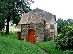
All Hallows church, Clixby
 Clixby shown within Lincolnshire
OS grid reference TA102042 Parish Grasby District West Lindsey Shire county Lincolnshire Region East Midlands Country England Sovereign state United Kingdom Post town Market Rasen Postcode district LN7 Police Lincolnshire Fire Lincolnshire Ambulance East Midlands EU Parliament East Midlands UK Parliament Gainsborough List of places: UK • England • Lincolnshire Clixby is a small village located about 2 miles (3.2 km) north of the town of Caistor, in the West Lindsey district of Lincolnshire, England. It lies in the Lincolnshire Wolds, a designated Area of Outstanding Natural Beauty.
Originally a township of Caistor, it was briefly a civil parish but since 1932 forms part of the civil parish of Grasby.[1]
Clixby was mentioned in Domesday Book of 1086, when the Lord of the Manor was King William I.[2] At the beginning of the 18th century Clixby was the seat of Sir John Fitzwilliam.[3]
The parish church was dedicated to All Hallows and dates from the 13th century with a 19th century restoration by Hodgson Fowler. It was declared redundant in 1973.[1][4]
References
- ^ a b "GENUKI". Clixby. GENUKI. http://www.genuki.org.uk/big/eng/LIN/Clixby/. Retrieved 16 June 2011.
- ^ "Domesday Map". Clixby. Anna Powell-Smith/University of Hull. http://www.domesdaymap.co.uk/place/TA1004/clixby/. Retrieved 16 June 2011.
- ^ "Lincs to the Past". Clixby Manor. Lincolnshire Archives. http://www.lincstothepast.com/CLIXBY-MANOR--GRASBY/229997.record?pt=S. Retrieved 16 June 2011.
- ^ "British Listed Buildings". All Hallows, Clixby. English Heritage. http://www.britishlistedbuildings.co.uk/en-196646-church-of-all-hallows-grasby. Retrieved 16 June 2011.
Categories:- Villages in Lincolnshire
- West Lindsey
- Lincolnshire geography stubs
Wikimedia Foundation. 2010.

