- Claxby St Andrew
-
Coordinates: 53°13′13″N 0°10′15″E / 53.22024400°N 0.17077661°E
Claxby St Andrew 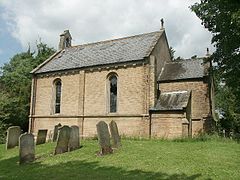
St Andrews church, Claxby St Andrew
 Claxby St Andrew
Claxby St Andrew shown within LincolnshireOS grid reference TF450714 Parish Well District East Lindsey Shire county Lincolnshire Region East Midlands Country England Sovereign state United Kingdom Post town Alford Postcode district LN13 Police Lincolnshire Fire Lincolnshire Ambulance East Midlands EU Parliament East Midlands UK Parliament Louth and Horncastle List of places: UK • England • Lincolnshire Claxby St Andrew (sometimes known as Claxby), is a village and former parish about 3 miles north of Alford, in the East Lindsey district of Lincolnshire, England.
The parish church, which was dedicated to Saint Andrew, was built in 1846, to replace an earlier thatched structure. It was declared redundant by the Diocese of Lincoln in 1990 and sold the same year. [1] It is a Grade II listed building.[2]
Claxby Manor House[1] (also known as Claxby Hall) was built around 1760, reputedly for Samuel Dashwood as the Dower House to Well Hall. It later became the vicarage, and is a Grade II listed building.[3]
Claxby Chalk Pit, also known as Mill Hill Quarry, is a Site of Special Scientific Interest[4] and nature reserve which lies east of the village.[5]
References
- ^ a b "GENUKI". GENUKI. http://www.genuki.org.uk/big/eng/LIN/ClaxbyWell/. Retrieved 18 May 2011.
- ^ "British Listed Buildings". British Listed Buildings. http://www.britishlistedbuildings.co.uk/en-195929-church-of-st-andrew-claxby. Retrieved 18 May 2011.
- ^ "British Listed Buildings". British Listed Buildings. http://www.britishlistedbuildings.co.uk/en-195930-claxby-hall-claxby. Retrieved 18 May 2011.
- ^ "Claxby Chalk Pit". Protected Planet. Protected Planet. http://protectedplanet.net/sites/Claxby_Chalk_Pit_Site_Of_Special_Scientific_Interest. Retrieved 5 July 2011.
- ^ "Mill Hill Quarry". Lincolnshire Wildlife Trust. Lincolnshire Wildlife Trust. http://www.lincstrust.org.uk/reserves/nr/reserve.php?mapref=33. Retrieved 5 July 2011.
Categories:- Villages in Lincolnshire
- East Lindsey
- Sites of Special Scientific Interest in Lincolnshire
- Lincolnshire geography stubs


Wikimedia Foundation. 2010.