- St Mary's Church, Luddenham
-
St Mary's Church, Luddenham 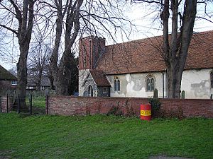
St Mary's Church, Luddenham, from the southeastLocation in Kent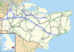
 St Mary's Church, Luddenham
Coordinates: 51°19′57″N 0°51′31″E / 51.3324°N 0.8586°E OS grid reference TQ 992 631 Location Luddenham, Kent Country England Denomination Anglican Website Churches Conservation Trust Architecture Functional status Redundant Heritage designation Grade I Designated 24 January 1967 Architectural type Church Style Norman, Gothic Specifications Materials Flint, partly rendered, and brick
Roofs tiledSt Mary's Church, Luddenham, is a redundant Anglican church in the village of Luddenham, Kent, England. It has been designated by English Heritage as a Grade I listed building,[1] and is under the care of the Churches Conservation Trust.[2] The church stands in a farmyard some 2 miles (3.2 km) northwest of Faversham.[2][3]
Contents
History
The church dates from the 12th century, and the chancel was added during the following century. The tower was rebuilt in 1807, the church was restored in 1881–84, and the porch was added in 1889.[1] The church was declared redundant on 16 May 1972, and was vested in the Churches Conservation Trust on 1 March 2002.[4] It is open daily to visitors.[2]
Architecture
St Mary's is constructed in flint, some of which has been rendered. It contains some re-used Roman tiles, the upper part of the tower is in brick, and the roofs are tiled. Its plan is simple and consists of a nave with a south porch, a chancel, and a tower in the southwest corner. The lower part of the tower dates from the 12th century, it is built in flint, and its quoins are Roman tiles. The upper part dates from the 1807 rebuilding, it is in brick, and has a battlemented parapet. The west door is Norman and is decorated with zigzags. The windows in the nave are lancets dating from the 14th and 19th centuries. The chancel has paired lancets in the east wall, and two separate lancets in the north wall.[1] Inside the church is a 13th-century coffin lid carved with hands holding a heart.[2]
External features
In the churchyard are three structures designated as Grade II listed buildings. To the north of the chancel is a monument dating from the early 19th century. Its inscriptions are illegible.[5] North west of the church is a chest tomb, also dating from the 19th century with illegible inscriptions.[6] Southwest of the church is a pair of headstones dated 1745 and 1747. They are carved with heads, skulls and a bible, in a heart-shaped surround.[7]
See also
- List of churches preserved by the Churches Conservation Trust in South East England
References
- ^ a b c "Church of St Mary, Luddenham", The National Heritage List for England (English Heritage), 2011, http://list.english-heritage.org.uk/resultsingle.aspx?uid=1069094, retrieved 18 April 2011
- ^ a b c d St Mary's Church, Luddenham, Kent, Churches Conservation Trust, http://www.visitchurches.org.uk/Ourchurches/Completelistofchurches/St-Marys-Church-Luddenham-Kent/, retrieved 3 April 2011
- ^ Luddenham Court, Streetmap, http://streetmap.co.uk/grid/599113_163192_120, retrieved 4 April 2011
- ^ (PDF) Diocese of Canterbury: All Schemes, Church Commissioners/Statistics, Church of England, 2011, p. 3, http://www.churchofengland.org/media/810388/canterbury%20-%20all%20schemes.pdf, retrieved 4 April 2011
- ^ "Monument 3 metres north of chancel Of Church of St Mary, Luddenham", The National Heritage List for England (English Heritage), 2011, http://list.english-heritage.org.uk/resultsingle.aspx?uid=1338568, retrieved 18 April 2011
- ^ "Chest tomb 20 metres northwest of Church of St Mary, Luddenham", The National Heritage List for England (English Heritage), 2011, http://list.english-heritage.org.uk/resultsingle.aspx?uid=1344018, retrieved 18 April 2011
- ^ "Pair of headstones about 20 metres southwest of Church of St Mary, Luddenham", The National Heritage List for England (English Heritage), 2011, http://list.english-heritage.org.uk/resultsingle.aspx?uid=1121907, retrieved 18 April 2011
Categories:- Grade I listed buildings in Kent
- Grade I listed churches
- Church of England churches in Kent
- Norman architecture
- English Gothic architecture
- Churches preserved by the Churches Conservation Trust


Wikimedia Foundation. 2010.