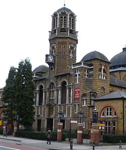
Christ Church Brixton Road
Look at other dictionaries:
Brixton Road — is a road in the London Borough of Lambeth (south London, England), leading from the Oval at Kennington to Brixton, where it forms the high street and then forks into Effra Road and Brixton Hill by the crossroads with Acre Lane and Coldharbour… … Wikipedia
Metropolitan Community Church in South London — Infobox MCC Congregation | name = Metropolitan Community Church in South London motto= God loves you as you are! founded= pastor=Rev Elder Jean White lay delegate= Sharon Jordan Passmore membership= worship= Sunday 18:30 free label = free text =… … Wikipedia
Chislehurst — Coordinates: 51°24′54″N 0°04′44″E / 51.4150°N 0.0789°E / 51.4150; 0.0789 … Wikipedia
List of churches in London — St. Paul s from the South London is the location of many famous churches, chapels and cathedrals, in a density unmatched anywhere else in England.[1] … Wikipedia
London — Die Buchstaben und Zahlen zwischen den Linien | H6 | bezeichnen die Quadrate des Planes. Abbeyfield RoadH6 Abbey RoadA1, 2 – StreetG2, 3; G5 Abercorn PlaceA2 Acacia RoadAB1, 2 AchillesB5 Acton StreetDE2 Adam StreetH5 Addington SquareF7 Adelaide… … Meyers Großes Konversations-Lexikon
Edmund Blacket — Anglican PortalEdmund Thomas Blacket (25 August 1817 – 9 February 1883) was an Australian architect, best known for his designs for the University of Sydney, St. Andrew s Cathedral, Sydney and St. Saviour s Cathedral, Goulburn. Arriving in Sydney … Wikipedia
London Borough of Lambeth — Infobox London Borough | name = London Borough of Lambeth short name = Lambeth imagename = status = London borough | area rank = 341st area km2 = 26.82 ons code = 00AY | adminhq = Brixton | ethnicity = 55.4% White 45.9% British 9.9% Portuguese… … Wikipedia
Orpington — For the breed of chicken, see Orpington (chicken). Coordinates: 51°22′27″N 0°05′55″E / 51.3741°N 0.0986°E / 51.3741; 0.0986 … Wikipedia
New Malden — Coordinates: 51°24′00″N 0°15′07″W / 51.40°N 0.252°W / 51.40; 0.252 … Wikipedia
Warminster — infobox UK place country = England official name= Warminster population= 17,377 shire district= West Wiltshire shire county = Wiltshire region= South West Englandconstituency westminster= Westbury post town= Warminster postcode district = BA12… … Wikipedia