Chiltern Park Aerodrome

Chiltern Park Aerodrome
ChilternParkWindsock.jpg
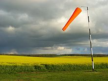
The wind sock at Chiltern Park
IATA: noneICAO: none
Summary
Airport type Private
Owner Chiltern Aerosports
Location Ipsden, Oxfordshire
Elevation AMSL 180 ft / 55 m
Coordinates 51°3310N 001°0602W / 51.55278°N 1.10056°W / 51.55278; -1.10056Coordinates: 51°3310N 001°0602W / 51.55278°N 1.10056°W / 51.55278; -1.10056
Website www.chiltern.aero
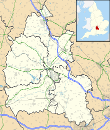
Map
Chiltern Park is located in Oxfordshire
Chiltern Park
Location in Oxfordshire
Runways
Direction Length Surface
m ft
04R/22L 550 1,804 Grass
04L/22R 700 2,297 Grass
15/33 420 1,378 Grass

Chiltern Park Aerodrome is a private airfield near Ipsden in Oxfordshire.[1] It is within RAF Benson's Military Aerodrome Traffic Zone.[2]

The airfield was established in 1988,[3] and caters for gyroplanes, microlights, helicopters, and gliders, as well as general aircraft.[4]

References

  1. ^ "Chiltern Park Airfield Card". Flightnav. 2009. http://www.flightnav.co.uk/Airfield/CHILTERNPARK. Retrieved 12 December 2010. 
  2. ^ Action for Airfields (2003). "ALERT: Chiltern Park 12/02/01". A4A. http://www.airfields.org.uk/alerts/chiltern_010212.htm. Retrieved 12 December 2010. 
  3. ^ "Diary". Benson Bulletin. 2009. http://www.bensonbulletin.com/diary/airamb.pdf. Retrieved 12 December 2010. 
  4. ^ Chiltern Park Aerodrome (2010). "Airfield Info". Chiltern Airsports Ltd. http://www.chiltern.aero/page.php?page=Airfield_Info. Retrieved 12 December 2010. 

Wikimedia Foundation. 2010.

Игры ⚽ Нужен реферат?

Look at other dictionaries:

  • Chiltern Main Line — Chiltern Railways Clubman at West Ruislip Overview Type Commuter rail, Heavy rail S …   Wikipedia

  • Chiltern Way — The Chiltern Way is a waymarked long distance footpath in southern England in the United Kingdom. Contents 1 Length of the route 2 The route 3 See also 4 External links …   Wikipedia

  • Denham Aerodrome — Cabair at Denham IATA: none – ICAO: EGLD …   Wikipedia

  • Reading, Berkshire — Reading   Town Borough   …   Wikipedia

  • Metropolitan line — Metropolitan Colour on map Magenta Year opened 1863 Line type Sub Surface Rolling stock A Stock and S Stock 8 carriages pe …   Wikipedia

  • Varsity Line — [v · d · …   Wikipedia

  • Brill Tramway — Manning Wardle engine Huddersfield at Quainton Road in the late 1890s with the Wotton Tramway s passenger coach of the mid 1870s, an 1895 Oxford Aylesbury Tramroad passenger coach, and a goods wagon loaded with milk cans Locale Aylesbury Va …   Wikipedia

  • Infrastructure of the Brill Tramway — Brill Tramway Legend …   Wikipedia

  • Watford — This article is about the town in Hertfordshire. For other uses, see Watford (disambiguation). For the council, see Watford Borough Council. Watford   Town and Borough   Borough of Watford …   Wikipedia

  • Northamptonshire — Coordinates: 52°17′N 0°50′W / 52.283°N 0.833°W / 52.283; 0.833 …   Wikipedia

Share the article and excerpts

Direct link
https://en-academic.com/dic.nsf/enwiki/11530706 Do a right-click on the link above
and select “Copy Link”