- Charnwood (ward)
-
Coordinates: 52°39′00″N 1°05′46″W / 52.650°N 1.096°W
Charnwood 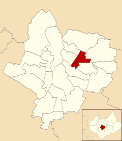
Population 10,664 Unitary authority Leicester Ceremonial county Leicestershire Region East Midlands Country England Sovereign state United Kingdom Post town LEICESTER Postcode district LE5 Dialling code 0116 Police Leicestershire Fire Leicestershire Ambulance East Midlands EU Parliament East Midlands UK Parliament Leicester East List of places: UK • England • Leicestershire Charnwood is an electoral ward and administrative division of the city of Leicester, England. It comprises the northern Leicester suburb of Northfields and its Tailby and Morton ex-council estates.
Contents
Geography
Charnwood is bounded by the wards of Belgrave to the north-west, Rushey Mead to the north, Humberstone & Hamilton to the east, Coleman to the south, Spinney Hills to the south-west and Latimer to the west.[1]
To the west, the Midland Main Line separates it from Belgrave, and to the south the Uppingham Road separates it from Spinney Hills and North Evington. To the east it borders Humberstone, and to the north borders the Troon Way industrial estate.
History
Northfields was named for Leicester's historic North Fields. The area was bombed in 1940 causing considerable damage. Many structures were destroyed and 4 people were killed.
Northfields also had 3 football teams dating from 1956. These were Northfield Town, Northfield United and the Northfield reserves.
Demographics
Northfields has had a bad reputation for criminal activities. Despite being only 3 small estates it was responsible for 30% of the crime rate within the Leicester area. In response The Northfields Project was set up in order to help to combat crime and make Northfields a safer place to live. The scheme improved areas such as security fencing, lighting and public recreational spaces.
Transport
Charnwood ward is served by Arriva Leicester Services 58/58A, Centrebus Services 10/11, Leicester City Bus Services 21/21A and Coachmaster Services 39 and 52.
References
- ^ Leicester City Council. "Ward Maps". http://www.leicester.gov.uk/your-council-services/council-and-democracy/city-statistics/wardprofiles/wardmaps/#Current-wards-map. Retrieved 2011-10-11.
The Northfields Project Report
Leicester East Belgrave • Evington • Charnwood • Coleman • Humberstone & Hamilton • Latimer • Rushey Mead • Thurncourt
Leicester South Aylestone • Castle (City Centre) • Eyres Monsell • Freemen • Knighton • Spinney Hills • Stoneygate
Leicester West Abbey • Beaumont Leys • Braunstone Park & Rowley Fields • Fosse • New Parks • Westcotes • Western Park
Categories:- Areas of Leicester
- Leicester

Wikimedia Foundation. 2010.