- Chapel, West Virginia
-
Chapel, West Virginia — Unincorporated community — 
 Chapel, West Virginia
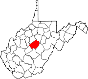
Coordinates: 38°44′51″N 80°48′17″W / 38.7475°N 80.80472°WCoordinates: 38°44′51″N 80°48′17″W / 38.7475°N 80.80472°W Country United States State West Virginia County Braxton Elevation 912 ft (278 m) Time zone Eastern (EST) (UTC-5) - Summer (DST) EDT (UTC-4) Area code(s) 304 & 681 GNIS feature ID 1537194[1] Chapel is an unincorporated community in Braxton County, West Virginia, United States. Chapel is 5.5 miles (8.9 km) north-northwest of Gassaway,[citation needed] along the Left Fork Steer Creek.[2]
References
- ^ U.S. Geological Survey Geographic Names Information System: Chapel, West Virginia
- ^ West Virginia Atlas & Gazetteer. Yarmouth, Me.: DeLorme. 1997. p. 45. ISBN 0-89933-246-3.
Municipalities and communities of Braxton County, West Virginia County seat: Sutton Towns Burnsville | Flatwoods | Gassaway | Sutton
Unincorporated
communitiesFootnotes ‡This populated place also has portions in an adjacent county or counties
Categories:- Populated places in Braxton County, West Virginia
- Unincorporated communities in West Virginia
- Mountain Lakes geography stubs


Wikimedia Foundation. 2010.