- Changhai County
-
Changhai County (simplified Chinese: 长海县; traditional Chinese: 長海縣; pinyin: Chánghǎi Xiàn; literally "Long Sea") is a county under the administration of Dalian city in Liaoning Province of the People's Republic of China. It consists of several islands in the Yellow Sea and is located offshore of the Liaodong Peninsula. There are 112 small islands and reefs in the county, traditionally called the Outer Chang Mountains Island Chain. The county has a total area of 119 square kilometers, and a population of approximately 80,000 people. The county's postal code is 116500, and the county government is located in the Dongshan neighborhood of the town of Dachangshandao.
Administrative Divisions[1]
There are 2 towns and 3 township in the county.
Towns:
- Dachangshandao (大长山岛镇), Zhangzidao (獐子岛镇)
Townships:
- Guanglu Township (广鹿乡), Haiyang Township (海洋乡), Xiaochangshan Township (小长山乡)
References
External Links
Liaoning Province county-level divisions Shenyang: Shenhe District · Huanggu District · Heping District · Dadong District · Tiexi District · Sujiatun District · Dongling District · Shenbei New Area · Yuhong District · Xinmin City · Faku County · Liaozhong County · Kangping County · Hunnan New Area*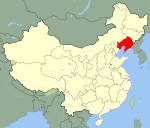 Liaoning in China
Dalian: Xigang District · Zhongshan District · Shahekou District · Ganjingzi District · Lüshunkou District · Jinzhou District (Jinzhou New Area*) · Wafangdian City · Pulandian City · Zhuanghe City · Changhai County
Anshan: Tiedong District · Tiexi District · Lishan District · Qianshan District · Haicheng City · Tai'an County · Xiuyan Autonomous County
Fushun: Shuncheng District · Xinfu District · Dongzhou District · Wanghua District · Fushun County · Xinbin Autonomous County · Qingyuan Autonomous County
Benxi: Pingshan District · Xihu District · Mingshan District · Nanfen District · Benxi Autonomous County · Huanren Autonomous County
Dandong: Zhenxing District · Yuanbao District · Zhen'an District · Fengcheng City · Donggang City · Kuandian Autonomous County
Jinzhou: Taihe District · Guta District · Linghe District · Linghai City · Beizhen City · Heishan County · Yi County
Yingkou: Zhanqian District · Xishi District · Bayuquan District · Laobian District · Dashiqiao City · Gaizhou City
Fuxin: Haizhou District · Xinqiu District · Taiping District · Qinghemen District · Xihe District · Zhangwu County · Fuxin Autonomous County
Liaoyang: Baita District · Wensheng District · Hongwei District · Gongchangling District · Taizihe District · Dengta City · Liaoyang County
Panjin: Xinglongtai District · Shuangtaizi District · Dawa County · Panshan County
Tieling: Yinzhou District · Qinghe District · Diaobingshan City · Kaiyuan City · Tieling County · Xifeng County · Changtu County
Chaoyang: Shuangta District · Longcheng District · Beipiao City · Lingyuan City · Chaoyang County · Jianping County · Harqin Autonomous County
Huludao: Longgang District · Lianshan District · Nanpiao District · Xingcheng City · Suizhong County · Jianchang CountyCoordinates: 39°16′22″N 122°35′19″E / 39.27278°N 122.58861°E
Categories:- Liaoning geography stubs
- County-level divisions of Liaoning

Wikimedia Foundation. 2010.