- North Turramurra, New South Wales
-
North Turramurra
Sydney, New South Wales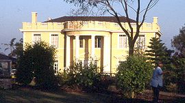
Local home in Bobbin Head RoadPopulation: 3,841 (2006 census) Established: 1850s Postcode: 2074 Area: 11.74 km² (4.5 sq mi) Location: 22 km (14 mi) north-west of Sydney LGA: Ku-ring-gai Council State District: Davidson Federal Division: Bradfield Suburbs around North Turramurra: North Wahroonga Ku-ring-gai Chase National Park Ku-ring-gai Chase National Park Wahroonga North Turramurra St Ives Chase Turramurra Pymble St Ives North Turramurra is a suburb on the Upper North Shore of Sydney, in the state of New South Wales, Australia. Turramurra is located 20 kilometres (12 mi) north-west of the Sydney central business district, in the local government area of Ku-ring-gai Council. Turramurra and South Turramurra are separate suburbs.
Contents
History
Turramurra is an Aboriginal word meaning high hill. Early settlers referred to the area as Eastern Road until the name Turramurra was adopted when the railway station was built in 1890. Eastern Road was an area of orchards. Samuel King, born in 1828 in County Donegal Ireland, arrived in Sydney in 1853. With his wife Ann, he established several orchards along Bobbin Head Road and at North Turramurra and was a noted church and community supporter.[1]
Eccleston du Faur secured the name Turramurra. Du Faur was born in England in 1832 and was recognised in Sydney as a supporter of the arts and sciences. He was elected a Fellow of the Royal Geographic Society in 1875 and was an early bush conservationist. Most importantly, Du Faur secured the land for the Ku-ring-gai Chase National Park from the government of the day. The Chase was declared in 1894. Du Faur personally funded and made a road through the bushland to Bobbin Head. In 1895 he built a house on 25 acres (100,000 m2) at the Chase Gates. After his death in 1915, part of this property became Lady Davidson Home, a convalescent hospital, later Lady Davidson Hospital.[2]
Landmarks
North Turramurra is home to the sphinx war memorial. This 1.5 m high replica of the Great Sphinx of Egypt was carved out of sandstone in the 1920s by a returned soldier, in memory of fallen comrades. The suburb is a popular starting point for many bush walkers as it has easy access to Bobbin Head, the upper reaches of Cowan Creek and St Ives Chase. North Turramurra is also the site of an official Bureau of Meteorology rainfall observation station [1].
Geography
North Turramurra lies on a narrow spur between two creeks (Lovers Jump Creek and Cowan Creek) that flow eventually to the sea through the Ku-ring-gai Chase National Park on the northern outskirts of the city. The heavily forested valleys pose a bush-fire threat each summer, but residents are blessed with common sightings of a wide variety of peculiar and beautiful native wildlife. This is a suburb where you can often see wallabies hopping around backyards.
Commercial area
There is a shopping village in North Turramurra on Bobbin Head Road which has an IGA supermarket, bakery, restaurants, post office, newsagent and other facilities.
Education
Public education is provided by:
- Ku-ring-gai Creative Arts High School
- Turramurra North Public School. The school was established in 1914.
Climate
North Turramurra has tropical summers (humid a warm) and Cool-Cold Winters North Turramurra hasn't been Below Freezing Point for years and the last recorded snow fall was in 1836. North Turramurra gets rain all year round with the most in February (231.9mm). On February 6, 2010 North Turramurra got 180mm of rain in 1 day thats almost 1 month of rain in a day and the most rain recorded since 1990 and on February 12/13, 2010 North Turramurra got 60mm in a night and on February 13, 2010 80mm of rain was recorded in North Turramurra. The highest recorded temperature was 46°C on the 14th of January 1939. -5 is an unofficial record low in 1836.
Climate data for North Turramurra Month Jan Feb Mar Apr May Jun Jul Aug Sep Oct Nov Dec Year Record high °C (°F) 46
(115)43
(109)40
(104)34
(93)30
(86)27
(81)26
(79)31
(88)34
(93)38
(100)41
(106)42
(108)46
(115)Average high °C (°F) 26
(79)25
(77)24
(75)22
(72)19
(66)16
(61)16
(61)17
(63)20
(68)22
(72)24
(75)25
(77)22 Average low °C (°F) 18
(64)17
(63)16
(61)12
(54)9
(48)7
(45)5
(41)8
(46)9
(48)11
(52)13
(55)15
(59)12 Record low °C (°F) 9
(48)8
(46)8
(46)7
(45)−1
(30)−3
(27)−5
(23)−4
(25)−1
(30)3
(37)4
(39)7
(45)−5
(23)Precipitation mm (inches) 200.1
(7.878)231.9
(9.13)160.4
(6.315)134.4
(5.291)109.7
(4.319)117.5
(4.626)97.3
(3.831)83.2
(3.276)81.1
(3.193)101.6
(4)112.1
(4.413)125.9
(4.957)1,515.2
(59.654)% humidity 64 68 57 53 50 47 44 46 51 52 57 60 55 Avg. precipitation days 17 22 15 14 12 11 10 11 12 12 12 13 161 Sunshine hours 223 190 194 189 179 164 175 200 208 222 230 240 2,482 Source: Bureau of Meteorology[3] Transport
The nearest train station is Turramurra railway station. Buses to North Turramurra are serviced by Shorelink at Turramurra train station. Shorelink bus route 577 runs through North Turramurra. Burns Road creates a boundary with Turramurra, to the south.
Hospitals
- Lady Davidson Private Hospital one of the largest dedicated rehabilitation hospital in Australia and has a long and distinguished history of providing health services for veterans and private patients.
- Nazareth House is an Aged car hospital run by the Sisters of Nazareth
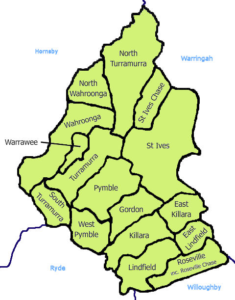
 Ku-ring-gai Council area
Population
The suburb is characterised by a close-knit community and has a strong community group known as NTAG (North Turramurra Action Group), which is one of the most active and successful community groups in the Ku-ring-gai area.
References
- ^ North Shore, Sydney: from 1788 to today, Les G. Thorne, Sydney: Angus & Robertson, 2nd rev. ed. 1970
- ^ The Book of Sydney Suburbs, Compiled by Frances Pollen, Angus & Robertson Publishers, 1990, Published in Australia ISBN 0-207-14495-8, page 256
- ^ "Sydney (Observatory Hill)". Climate statistics for Australian locations. Bureau of Meteorology. http://www.bom.gov.au/climate/averages/tables/cw_066062.shtml. Retrieved 11 December 2009.
External links
- North Turramurra, New South Wales is at coordinates 33°43′34″S 151°08′50″E / 33.72615°S 151.14712°ECoordinates: 33°43′34″S 151°08′50″E / 33.72615°S 151.14712°E
- Turramurra & Kissing Point Rover Crews - for young people aged 17~25
Suburbs and localities of Ku-ring-gai Council | North Shore | Sydney Suburbs East Killara · East Lindfield · Gordon · Killara · Lindfield · North Turramurra · North Wahroonga · Pymble · Roseville · Roseville Chase · South Turramurra · St Ives · St Ives Chase · Turramurra · Wahroonga · Warrawee · West Pymble
Localities East Gordon · East Turramurra · West Killara · West Lindfield
Categories:- Suburbs of Sydney

Wikimedia Foundation. 2010.