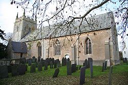
All Saints' Church, Granby

All Saints' Church, Granby

Coordinates: 52°53′03″N 00°53′03″W / 52.88417°N 0.88417°W / 52.88417; -0.88417

All Saints' Church, Granby


Denomination Church of England
Churchmanship Broad Church
Website www.wivertonchurches.org.uk/allsaints/allsaints.htm
History
Dedication All Saints
Administration
Parish Granby, Nottinghamshire
Diocese Southwell and Nottingham
Province York
Clergy
Rector Revd Bronwen Gamble

All Saints' Church, Granby is a parish church in the Church of England in Granby, Nottinghamshire.

The church is Grade I listed by the Department for Culture, Media & Sport as a building of outstanding architectural or historic interest.

History

The church is medieval but was reduced in size and the tower repaired c. 1777. The chancel originally had a terracotta east window, replaced by one of stone in 1888. Fragments of the original, including two cusped heads, lie in the chancel [1].

Current parish status

All Saints' Church, Granby is in the Wiverton group of parishes which includes:

Source

  1. ^ Pevsner, Nikolaus. 1979. The Buildings of England:Nottinghamshire. page 134.Harmondsworth, Middx. Penguin.

Wikimedia Foundation. 2010.

Игры ⚽ Нужна курсовая?

Look at other dictionaries:

  • St. Michael and All Angels' Church, Elton on the Hill — Parish church name = St. Michael and All Angels Church, Elton on the Hill caption = dedication = St. Michael and All Angels denomination = Church of England tradition = Broad Church parish = Elton on the Hill deanery = archdeaconry = diocese =… …   Wikipedia

  • Granby, Nottinghamshire — Granby is a small village in the Vale of Belvoir. It has a population of about 300 people, and is situated about 14 miles east of Nottingham. The parish church of All Saints is 12th century. There is no longer a school in Granby. In its place is… …   Wikipedia

  • St. Andrew's Church, Langar — Coordinates: 52°54′17″N 00°55′44″W / 52.90472°N 0.92889°W / 52.90472; 0.92889 …   Wikipedia

  • St. Giles' Church, Cropwell Bishop — Coordinates: 52°54′46″N 00°58′59″W / 52.91278°N 0.98306°W / 52.91278; 0.98306 …   Wikipedia

  • Holy Trinity Church, Tythby — Coordinates: 52°55′31″N 00°57′47″W / 52.92528°N 0.96306°W / 52.92528; 0.96306 …   Wikipedia

  • St. John's Church, Colston Bassett — Parish church name = St. John s Church, Colston Bassett caption = dedication = St. John denomination = Church of England tradition = Broad Church parish = Colston Bassett deanery = archdeaconry = diocese = Southwell and Nottingham province = York …   Wikipedia

  • St. Mary's Church, Barnstone — Parish church name = St. Mary s Church, Barnstone caption = dedication = St. Mary denomination = Church of England tradition = Broad Church parish = Barnstone deanery = archdeaconry = diocese = Southwell and Nottingham province = York canon =… …   Wikipedia

  • Diocese of Southwell and Nottingham — Location Ecclesiastical province York Archdeaconries Newark, Nottingham Statistics Parishes …   Wikipedia

  • Liverpool — This article is about the city. For the football club, see Liverpool F.C.. For other uses, see Liverpool (disambiguation). Liverpool   Metropolitan borough …   Wikipedia

  • Chorlton-on-Medlock — Not to be confused with Chorlton cum Hardy. Coordinates: 53°28′00″N 2°13′00″W / 53.466667°N 2.216667°W / 53.466667; 2.21 …   Wikipedia

Share the article and excerpts

Direct link
Do a right-click on the link above
and select “Copy Link”