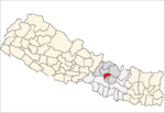
- Chhaimale
-
Chhaimale — Village development committee — Location in Nepal Coordinates: 27°35′24″N 85°15′36″E / 27.59°N 85.26°ECoordinates: 27°35′24″N 85°15′36″E / 27.59°N 85.26°E Country  Nepal
NepalZone Bagmati Zone District Kathmandu District Population (1991) – Total 3,675 – Religions Hindu Time zone Nepal Time (UTC+5:45) Chhaimale is a village in Kathmandu District in the Bagmati Zone of central Nepal. At the time of the 1991 Nepal census it had a population of 3675 and had 662 households in it.[1]
References
- ^ "Nepal Census 2001". Nepal's Village Development Committees. Digital Himalaya. http://www.digitalhimalaya.com/collections/nepalcensus/form.php?selection=1. Retrieved 2008-08-28.
Aalapot · Baad Bhanjyang · Bajrayogini · Balambu · Baluwa · Bhadrabas · Bhimdhunga · Budanilkantha · Chalnakhel · Chapali Bhadrakali · Chhaimale · Chobhar, Nepal · Chouketar Dahachok · Chunikhel · Daanchhi · Daxinkali · Dhapasi · Dharmasthali · Futung · Gapalphedi · Gokarna · Goldhunga · Gonggabu · Gothatar · Ichankhu Narayan · Indrayani · Jhor Mahankal · Jitpurphedi · Jorpati · Kabhresthali · Kapan · Khadka Bhadrakali · Kirtipur Chitubihar · Koteswor · Lapsiphedi · Machhegaun · Mahadevsthan, Kathmandu · Mahankal · Manmaiju · Matatirtha · Mulpani · Naglebhare · Naikap Naya Bhanjyang · Naikap Purano Bhanjyang · Nayapati · Pukhulachhi · Ramkot · Sangla · Satungal
· Seuchatar · Sheshnarayan · Sitapaila · Sokhek · Sundarijal · Suntol · Talkududechour · Thankot · Tinthana · Tokha Chandeswori · Tokha Sarswoti Categories:
- Populated places in Kathmandu District
- Bagmati Zone geography stubs
Wikimedia Foundation. 2010.


