Akademiya Nauk Range

Akademiya Nauk Range

Geobox|Range
name=Akademiya Nauk Range
Хребет Академии Наук
native_name=


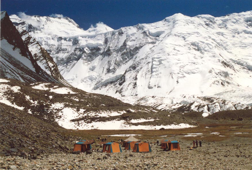
image_caption=Ismoil Somoni Peak in 1989
country=Tajikistan
region_type=
region=
parent=Pamir Mountains
geology=sedimentary and metamorphic rocks
period=Paleozoic
orogeny=
highest=Ismoil Somoni Peak
highest_elevation=7495
highest_lat_d=38|highest_lat_m=55|highest_lat_s=|highest_lat_NS=N
highest_long_d=72|highest_long_m=01|highest_long_s=|highest_long_EW=E


map_caption=

Akademiya Nauk Range ( _ru. Хребет Академии Наук, Tajik: Qatorkuhi Akademiyai Fanho) is a mountain range in the Western Pamirs of Tajikistan. It is stretched in the meridianal direction and considered to be the core of the Pamir mountain system.

The highest peak of the range is the Ismoil Somoni Peak. It was also the highest peak in the former Soviet Union. The length of the Akademiya Nauk Range is about 110 km. The crest of the range has an Alpine-like relief with 24 summits more than 6,000 m in height. The lowest saddle point, Kamaloyak (Камалояк), is at the altitude of 4,340 m (14,240 ft).

The range is formed with sedimentary and metamorphic rocks of the Paleozoic Era and partially granites. It is covered with permanent snow, which feeds a large number of big glaciers. The total area of the glacial ice is around 1,500 km². [ [http://bse.sci-lib.com/article005026.html "Big Soviet Encyclopedia", on-line edition, in Russian.] ]

The Akademiya Nauk Range was discovered by Russian geographer and Pamir explorer Nikolai Korzhenevskiy and named after the Soviet Academy of Sciences in 1927.

ee also

*Ismoil Somoni Peak
*Peak Korzhenevskaya
*Garmo Peak

References


Wikimedia Foundation. 2010.

Игры ⚽ Поможем написать реферат

Look at other dictionaries:

  • Akademiya Nauk Range — ▪ mountains, Tajikistan also spelled  Akademiia Nauk,  Russian  Khrebet Akademi Nauk        (“Academy of Sciences Range”), mountain range, western Pamirs, central Tajikistan. The mountains, extending north south, are approximately 68 miles (110… …   Universalium

  • Pamirs — /pah mearz /, n. the, a mountainous region in central Asia, largely in Tajikistan, where the Hindu Kush, Tien Shan, and Himalaya mountain ranges converge: highest peaks, ab. 25,000 ft. (7600 m). Also called Pamir. * * * High mountain region,… …   Universalium

  • Peak Korzhenevskaya — Infobox Settlement official name =PAGENAME native name = imagesize = image caption = image map caption = pushpin pushpin label position =right pushpin mapsize = 300 pushpin map caption =Location in Tajikistan subdivision type = Country… …   Wikipedia

  • Montes de la Academia de Ciencias — Pico Ismoil Somoni (antiguo Pico Comunismo) en 1989 …   Wikipedia Español

  • List of Russian explorers — The Russian Empire at its peak in 1866, including the spheres of influence; this territorial expansion largely corresponds to the extent of contiguous exploration by Russians. This is a list of explorers from the Russian Federation, Soviet Union …   Wikipedia

  • Tajikistan — Republic of Tajikistan Ҷумҳурии Тоҷикистон Çumhuriji Toçikiston …   Wikipedia

  • List of Russian people — The Millennium of Russia monument in Veliky Novgorod, featuring the statues and reliefs of the most celebrated people in the first 1000 years of Russian history …   Wikipedia

  • Mount Garmo — The Garmo Throbber Elevation 6,595 m (21 …   Wikipedia

  • Ismoil Somoni Peak — (then known as Communism Peak) taken in 1989. Elevation …   Wikipedia

  • Nikolai Korzhenevskiy — Nikolai Leopol dovich Korzhenevskiy (Russian: Николай Леопольдович Корженевский, February 6 (18), 1879 – October 31, 1958), born in Vitebsk Guberniya, Russia (today Belarus), died in Tashkent, Uzbekistan. A famous Russian and Soviet geographer,… …   Wikipedia

Share the article and excerpts

Direct link
Do a right-click on the link above
and select “Copy Link”