- Chernoochene
-
Chernoochene
ЧернооченеOverview of the village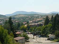 Location of Chernoochene
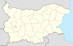
 Chernoochene
Coordinates: 41°46′N 25°21′E / 41.767°N 25.35°E Country  Bulgaria
Provinces
(Oblast)Kardzhali Government - Mayor Aydan Osman Elevation 564 m (1,850 ft) Population (2008)[1] - Total 335 Time zone EET (UTC+2) - Summer (DST) EEST (UTC+3) Postal Code 6701 Area code(s) 03691 Chernoochene (Bulgarian: Черноочене, pronounced [tʃɛrnuˈɔtʃɛnɛ]; Turkish: Karagözler) is a village in central southern Bulgaria, part of Kardzhali Province. It is the administrative centre of Chernoochene municipality, which comprises in the northernmost part of Kardzhali Province. The village is located in the Eastern Rhodope Mountains and has a predominantly Turkish population. The village's name roughly means "place of the black-eyed people" in both Bulgarian and Turkish.
Municipality
Chernoochene municipality covers an area of 339 square kilometres and includes the following 51 places:
- Bakalite
- Barza Reka
- Bedrovo
- Bezvodno
- Beli Vir
- Besnurka
- Bozhurtsi
- Borovsko
- Bosilitsa
- Bostantsi
- Cherna Niva
- Chernoochene
- Daskalovo
- Draganovo
- Dushka
- Dyadovsko
- Gabrovo
- Kableshkovo
- Kanyak
- Komuniga
- Kopitnik
- Kutsovo
- Lyaskovo
- Minzuhar
- Murga
- Nebeska
- Nochevo
- Novi Pazar
- Novoselishte
- Panichkovo
- Patitsa
- Pchelarovo
- Petelovo
- Pryaporets
- Rusalina
- Sokolite
- Srednevo
- Sredska
- Strazhnitsa
- Svobodinovo
- Vazel
- Versko
- Vodach
- Voynovo
- Vozhdovo
- Yabalcheni
- Yavorovo
- Yonchovo
- Zheleznik
- Zhenda
- Zhitnitsa
Gallery
-

Mosque in Chernoochene
External links
- Chernoochene municipality website (Bulgarian)
Ardino · Chernoochene · Dzhebel · Kardzhali · Kirkovo · Krumovgrad · Momchilgrad
Coordinates: 41°46′N 25°21′E / 41.767°N 25.35°E
Categories:- Villages in Kardzhali Province
- Turkish communities in Bulgaria
- Bulgaria geography stubs


Wikimedia Foundation. 2010.