- Cohagen, Montana
-
- Cohagen redirects here. Not to be confused with Cohaagen, a character in the film Total Recall.
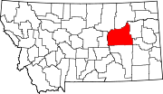
Cohagen, Montana — Unincorporated community — Location within the state of Montana Coordinates: 47°3′16″N 106°37′3″W / 47.05444°N 106.6175°WCoordinates: 47°3′16″N 106°37′3″W / 47.05444°N 106.6175°W Country United States State Montana County Garfield Elevation 2,720 ft (829 m) Time zone Mountain (MST) (UTC-7) – Summer (DST) MDT (UTC-6) ZIP codes 59322 FIPS code GNIS feature ID 806931 Cohagen is an unincorporated community in southeastern Garfield County, Montana, United States. It lies along Highway 59 southeast of the town of Jordan, the county seat of Garfield County.[1] Its elevation is 2,720 feet (829 m).[2] Although Cohagen is unincorporated, it has a post office, with the ZIP code of 59322,[3] which opened on 1905-08-18.[4]
References
- ^ Rand McNally. The Road Atlas '08. Chicago: Rand McNally, 2008, p. 61.
- ^ U.S. Geological Survey Geographic Names Information System: Cohagen, Montana
- ^ Zip Code Lookup
- ^ U.S. Geological Survey Geographic Names Information System: Cohagen Post Office
Municipalities and communities of Garfield County, Montana Town Unincorporated
communitiesBrusett | Cohagen | Mosby | Sand Springs
Categories:- Populated places in Garfield County, Montana
- Unincorporated communities in Montana
- Montana geography stubs
Wikimedia Foundation. 2010.


