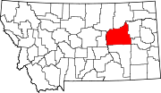
- Mosby, Montana
-
Mosby, Montana — Unincorporated community — Location within the state of Montana Coordinates: 46°59′32″N 107°53′1″W / 46.99222°N 107.88361°WCoordinates: 46°59′32″N 107°53′1″W / 46.99222°N 107.88361°W Country United States State Montana County Garfield Elevation 2,513 ft (766 m) Time zone Mountain (MST) (UTC-7) - Summer (DST) MDT (UTC-6) ZIP codes 59058 FIPS code GNIS feature ID 774406 Mosby (also Half-Breed Crossing) is an unincorporated community in southwestern Garfield County, Montana, United States. It lies along Highway 200 southwest of the town of Jordan, the county seat of Garfield County.[1] Its elevation is 2,513 feet (766 m).[2] Mosby had a post office that opened on 1904-06-29 and closed on 1983-02-18,[3] but the community still has a separate ZIP code of 59058.[4]
References
- ^ Rand McNally. The Road Atlas '08. Chicago: Rand McNally, 2008, p. 61.
- ^ U.S. Geological Survey Geographic Names Information System: Mosby, Montana
- ^ U.S. Geological Survey Geographic Names Information System: Mosby Post Office
- ^ Zip Code Lookup
Municipalities and communities of Garfield County, Montana County seat: Jordan Town Unincorporated
communitiesBrusett | Cohagen | Mosby | Sand Springs
Categories:- Populated places in Garfield County, Montana
- Unincorporated communities in Montana
- Montana geography stubs
Wikimedia Foundation. 2010.


