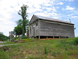
Creelsboro, Kentucky

Creelsboro, Kentucky
Creelsboro
—  Ghost town  —
Creelsboro, Kentucky
Creelsboro is located in Kentucky
Creelsboro
Location within the state of Kentucky
Coordinates: 36°53′06″N 85°11′51″W / 36.885°N 85.1975°W / 36.885; -85.1975Coordinates: 36°53′06″N 85°11′51″W / 36.885°N 85.1975°W / 36.885; -85.1975
Country United States
State Kentucky
County Russell
Time zone Central (CST) (UTC-6)
 – Summer (DST) CDT (UTC-5)
ZIP codes
FIPS code
GNIS feature ID

Creelsboro is a ghost town in Russell County, Kentucky, United States. The historic town was thriving some sixteen years before Russell County was formed. It was named for Elijah Creel, an early settler, and was at one time the busiest river port on the Cumberland River between Nashville, Tennessee, and Burnside, Kentucky. The town hosted a bank, school, three stores and a building that provided lodging for steam boat passengers. Creelsboro was a major trade center along the Cumberland River in the 19th century, although its actual population was only about 50. With the construction of the Wolf Creek Dam, traffic from steamboats and other vessels greatly decreased. Creelsboro's current population primarily are involved in agriculture. Many tourists visit the area to access the Cumberland River for trout fishing and other recreational boating activities.

External links


Wikimedia Foundation. 2010.

Игры ⚽ Поможем написать реферат

Look at other dictionaries:

  • Creelsboro Natural Bridge — (more commonly referred to as Rock House or the Rockhouse) is a natural bridge in southwestern Russell County, Kentucky, USA (36°53 5.97 N 85°14 11.13 W). It is located near the community of Creelsboro, approximately seven miles downstream from… …   Wikipedia

  • Crocus, Kentucky — Crocus   Unincorporated community   …   Wikipedia

  • National Register of Historic Places listings in Russell County, Kentucky — Location of Russell County in Kentucky This is a list of the National Register of Historic Places listings in Russell County, Kentucky. It is intended to be a complete list of the properties on the National Register of Historic Places in Russell… …   Wikipedia

  • Russell County, Kentucky — Infobox U.S. County county = Russell County state = Kentucky founded year = 1826 founded date = seat wl = Jamestown largest city wl = Russell Springs area total sq mi = 283 area total km2 = 732 area land sq mi = 254 area land km2 = 657 area water …   Wikipedia

  • Wolf Creek Dam — Infobox Dam dam name=Wolf Creek Dam caption= official name= crosses=Cumberland River reservoir=Lake Cumberland locale=Russell County, Kentucky maint=USACE length=5,736 feet (1,748 m) height=258 feet (78.6 m) width= began= open= closed= reservoir… …   Wikipedia

  • Natural arch — Natural bridges redirects here. For the U.S. National Monument, see Natural Bridges National Monument. The Delicate Arch in Arches National Park in Utah, United States. A natural arch or natural bridge is a natural geological formation where a… …   Wikipedia

  • Liste Des Villes Fantômes Aux États-Unis — Liste des villes fantômes des États Unis Cet article recense des villes fantômes aux États Unis. Sommaire 1 Liste par État 1.1 Alabama 1.2 Alaska 1.3 Arizona …   Wikipédia en Français

  • Liste des villes fantomes aux Etats-Unis — Liste des villes fantômes des États Unis Cet article recense des villes fantômes aux États Unis. Sommaire 1 Liste par État 1.1 Alabama 1.2 Alaska 1.3 Arizona …   Wikipédia en Français

  • Liste des villes fantômes — des États Unis Cet article recense des villes fantômes aux États Unis. Sommaire 1 Liste par État 1.1 Alabama 1.2 Alaska 1.3 Arizona …   Wikipédia en Français

  • Liste des villes fantômes aux États-Unis — Liste des villes fantômes des États Unis Cet article recense des villes fantômes aux États Unis. Sommaire 1 Liste par État 1.1 Alabama 1.2 Alaska 1.3 Arizona …   Wikipédia en Français

Share the article and excerpts

Direct link
Do a right-click on the link above
and select “Copy Link”