Sherman Falls (Hamilton, Ontario)
- Sherman Falls (Hamilton, Ontario)
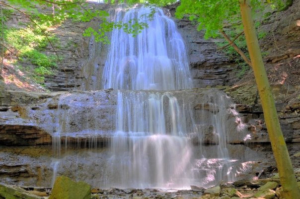
Infobox Waterfall
name = Sherman Falls
image_size =
caption = Chedoke Falls
location = Hamilton, Ontario
latitude =
longitude =
coordinates = coord|43.235699|-79.974289
elevation =
type = Ribbon
height = convert|17|m|ft|abbr=on
width = convert|8|m|ft|abbr=on
height_longest =
average_width =
number_drops =
average_flow =
watercourse = Ancaster Creek
world_rank = Sherman Falls is a 17 metre high curtain waterfall found in Ancaster Heights, the western end of Hamilton, Ontario, Canada.[cite web|url=http://www.cityofwaterfalls.ca/waterfall_types.html|title=Hamilton- City of Waterfalls (Ecklund Marketing Group)|accessdate=2008-07-20] The watercourse is Ancaster Creek. Alternative names for the Sherman Falls include; "Smith's Falls" and "Whitton Falls."]
Nearby attractions include the Old Mill Restaurant[cite web|url=http://www.ancasteroldmill.com/|title=The Ancaster Old Mill|accessdate=2008-07-20] , Dundas Valley Conservation Area, Tiffany Falls Conservation Area, the Bruce Trail, Iroquoia Heights Conservation Area, Hermitage ruins, Grifffin House, Fieldcote Museum. There's also a convenience store, restaurant and retail stores nearby.][cite book| title = Hamilton Waterfalls and Cascades: Research & Inventory Report, 2nd Edition| publisher = Hamilton Conservation Authority| date = November 2007] ]
Directions
You can enter Sherman Falls at "Upper Lions Club Road" at "Old Dundas Road". Walk up the East side of Ancaster Creek to Sherman Falls.[cite web|url=http://www.penny.ca/Waterfalls.htm|title=Hamilton Wentworth Waterfalls|accessdate=2008-07-20] This waterfall is just steps away from the Bruce Trail of the Dundas Valley.]
References
External links
* [http://www.cityofwaterfalls.ca/ Hamilton- "The Waterfall Capital of the World" (www.cityofwaterfalls.ca)]
* [http://www.brucetrail.org Bruce Trail (www.brucetrail.org)]
* [http://www.hamiltonpostcards.com/pages/waterfalls.html Vintage Postcards: Waterfalls in and around Hamilton, Ontario]
Maps
* [http://map.hamilton.ca/Static/PDFs/General%20Interest%20maps/Overall%20City/WaterfallMap.pdf Hamilton Waterfall Map PDF. (http://map.hamilton.ca)]
* [http://www.hamiltonnature.org/waterfalls/waterfalls.html
) ]
]
Wikimedia Foundation.
2010.
Look at other dictionaries:
Tiffany Falls (Hamilton, Ontario) — See also: List of waterfalls in Hamilton, Ontario Tiffany Falls Location Hamilton, Ontario Coordinates … Wikipedia
Canterbury Falls (Hamilton, Ontario) — Infobox Waterfall name = Canterbury Falls image size = caption = Canterbury Falls location = Hamilton, Ontario latitude = longitude = coordinates = coord|43.233197| 79.979782 elevation = type = Ribbon height = convert|9|m|ft|abbr=on width =… … Wikipedia
Hamilton, Ontario — For Hamilton Township in Northumberland County, see Hamilton, Ontario (township). Hamilton City City of Hamilton … Wikipedia
Hamilton (Ontario) — Pour les articles homonymes, voir Hamilton. Hamilton Vue d Hamilton … Wikipédia en Français
Cochrane Road (Hamilton, Ontario) — Albion Falls, King s Forest Park See also: List of streets in Hamilton, Ontario Cochrane Road is a two way Lower City collector road in Hamilton, Ontario, Canada. It starts off at the Queenston Traffic Circle and travels South between the… … Wikipedia
Dundurn Street (Hamilton, Ontario) — Dundurn Castle at Dundurn Park. (Summer) See also: List of streets in Hamilton, Ontario Dundurn Street, is a Lower City arterial road in Hamilton, Ontario, Canada. It is a two way street that starts off at Mountain Face Park, Niagara Escarpment… … Wikipedia
James Street (Hamilton, Ontario) — LIUNA Station (former Canadian National Railways Station), as seen from Immigration Square James Street is a Lower City arterial road in Hamilton, Ontario, Canada. It starts off at the base of the Niagara Escarpment from James Mountain Road, a… … Wikipedia
Concession Street (Hamilton, Ontario) — See also: List of streets in Hamilton, Ontario Concession Street is an Upper City (mountain) arterial road in Hamilton, Ontario, Canada. It starts at Belvidere Avenue, just West of Sam Lawrence Park, and extends eastward past Mountain Drive Park… … Wikipedia
Main Street (Hamilton, Ontario) — Main Street, looking East Main Street, is a Lower City arterial road in Hamilton, Ontario, Canada. It starts east of Wilson Street in Ancaster at White Chapel Cemetery as a two way street and switches over to a one way street (Eastbound) at… … Wikipedia
Ottawa Street (Hamilton, Ontario) — Ottawa street, is a Lower City arterial road in Hamilton, Ontario, Canada. It starts off at Lawrence Road at the base of the Niagara Escarpment (mountain) and is a two way street throughout cutting through the Delta and Crown Point neighbourhoods … Wikipedia