- Utah State Route 181
Infobox road
state=UT
type=SR
route=181
alternate_name=1300 East
section=124
maint=UDOTcite web | title=Utah Code, accessed from Internet Archive Wayback Machine | date=9 February 2007 | url=http://web.archive.org/web/20070209163440/http://le.utah.gov/~code/TITLE72/72_04.htm ]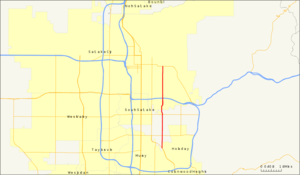
length_mi=6.904
length_round=3
length_ref=UDOT Highway Reference Information for SR-181, generated 2007-03-21]
established=1935
deleted=2007
direction_a=South
terminus_a=jct|state=UT|SR|152 near Holladay
junction=jct|state=UT|UT|171 near Salt Lake City
jct|state=UT|I|80 in Salt Lake City
direction_b=North
terminus_b=jct|state=UT|SR|186 in Salt Lake CityState Route 181 (SR-181) was a
state highway in theU.S. state ofUtah connecting SR-152 in Murray and Holladay north to SR-186 in Salt Lake City at its peak, the former being asuburb of the latter. The route was convert|6.9|mi|km|2 for thirty-eight years before being truncated in 2007 and decommissioned entirely later in the same year.When the route was formed in 1935, it went from SR-1 (US-89/US-91) near North Salt Lake southeast to the
Utah State Capitol , then south on State Street, east on South Temple, and south again on 1300 East to SR-4 (US-40) in Salt Lake City. The route was eventually truncated south to SR-186 and extended south to SR-152, then decommissioned north of SR-171 in 2007 and deleted entirely the same year.Route description
SR-181 began at the junction of SR-152 and 1300 East and headed north on the latter on a two-lane undivided highway in a suburban environment, as it was for most of the route. St. Mark's Hospital was located on the west side of SR-181 at the junction of 3900 South as it continued north. The highway expanded to four lanes past SR-171 and veered northwesterly, therefore going out of the alignment of 1300 East in the Salt Lake County grid system and becoming Richmond Street. This was brief, however, and it returned back to 1300 East on the grid alignment past Highland Drive when it reverted back to its original direction. This was the point when the highway widened to six lanes. SR-181 continued north to intersect I-80 and 2100 South, where it lost four of its six lanes. This stretch of road, from 2100 South north to 1300 South, was frequently congested. Westminster College was located on the west side of the road on this segment. The route gained a lane in the southbound section past 1300 South and another lane in the northbound section by 900 South. A block later, the road passed East High School to the east. It continued in this matter to its terminus at SR-186, near the
University of Utah and west of theRice-Eccles Stadium .cite web | title=Google Maps | publisher=Google | url=http://maps.google.com ]History
The state legislature formed State Route 181 in 1935, beginning at the junction of SR-1 (signed as US-89/US-91, now solely US-89) and going southeast on Victory Road to the
Utah State Capitol . It then went south on State Street to South Temple, turned east on that street and then turned south on 1300 East. It continued south to SR-4 (signed as US-40, now 2100 South), where it terminated. In 1957, the highway was extended south by Commission toSR-152 , which at that time ran along Highland Drive in the Sugarhouse section of Salt Lake City.Utah Department of Transportation , [http://www.udot.utah.gov/main/f?p=100:pg:5285268476414239680:::1:T,V:1348, Highway Resolutions] : PDFlink|1= [http://www.udot.utah.gov/main/uconowner.gf?n=200609190915031 Route 152] |2=4.55 MB, updated November 2007, accessed July 2008] In 1961, the highway was extended further south to SR-171. Another southward extension in 1969 brought the route to SR-152, which at that time was running along the Van Winkle Expressway. In the early-1990s, traffic planners planned to relieve the congestion that was affecting the two-lane section of the route between 2100 South and 1300 South by implementing a centerreversible lane .Citation
last = Johnson
first = Dave
title = Consultants Say Reversible Lanes to Beat Traffic
newspaper = Salt Lake Tribune, the
pages = D5
date = 28 March 1993
url = http://nl.newsbank.com/nl-search/we/Archives?p_product=SLTB&p_theme=sltb&p_action=search&p_maxdocs=200&p_topdoc=1&p_text_direct-0=10112FF3CD3532D4&p_field_direct-0=document_id&p_perpage=10&p_sort=YMD_date:D&s_trackval=GooglePM] The reversible lane would have flowed in a northbound direction in the morning and a southbound direction in the evening.Citation
title = S.L. May Try Reversible Lanes to Ease Logjam on 1300 East
newspaper = Salt Lake Tribune, the
pages = D3
date = 25 November 1991
url = http://nl.newsbank.com/nl-search/we/Archives?p_product=SLTB&p_theme=sltb&p_action=search&p_maxdocs=200&p_topdoc=1&p_text_direct-0=10117A671FA3D5BF&p_field_direct-0=document_id&p_perpage=10&p_sort=YMD_date:D&s_trackval=GooglePM] There would also be eight overhead signals spaced about a block apart each reminding motorists what direction the lane was flowing in. However, this plan never came to fruition due to local opposition over safety and cost and was canceled at the end of 1993.Citation
title = S.L. Says No to Lane Plan for 1300 East
newspaper = Deseret News, the
date = 16 December 1993
url = http://nl.newsbank.com/nl-search/we/Archives?p_product=NewsLibrary&p_multi=DSNB&d_place=DSNB&p_theme=newslibrary2&p_action=search&p_maxdocs=200&p_topdoc=1&p_text_direct-0=0F3608D7E0AAB686&p_field_direct-0=document_id&p_perpage=10&p_sort=YMD_date:D&s_trackval=GooglePM] Citation
title = Reversible Lane Isn't Likely to Get Green Light
newspaper = Deseret News, the
date = 11 August 1993
url = http://nl.newsbank.com/nl-search/we/Archives?p_product=NewsLibrary&p_multi=DSNB&d_place=DSNB&p_theme=newslibrary2&p_action=search&p_maxdocs=200&p_topdoc=1&p_text_direct-0=0F36080DA242BB00&p_field_direct-0=document_id&p_perpage=10&p_sort=YMD_date:D&s_trackval=GooglePM] Citation
title = Resident Leery of Reversible Lanes
newspaper = Deseret News, the
date = 17 June 1993
url = http://nl.newsbank.com/nl-search/we/Archives?p_product=NewsLibrary&p_multi=DSNB&d_place=DSNB&p_theme=newslibrary2&p_action=search&p_maxdocs=200&p_topdoc=1&p_text_direct-0=0F3607C0DF2AE548&p_field_direct-0=document_id&p_perpage=10&p_sort=YMD_date:D&s_trackval=GooglePM] On 17 October 2007, the portion of the route in Salt Lake City city limits (north of SR-171 was transferred to the city's ownership. On 7 December of the same year, the remainder of the route was transferred to Salt Lake County's jurisdiction.cite web | title=State Route 181 History | publisher=Utah Department of Transportation | url=http://www.dot.utah.gov/main/uconowner.gf?n=200609190953381]Major intersections
This table reflects the routing 1969–17 October 2007. The entire route was in Salt Lake County.cite web | title=Wasatch Front Inset Map | publisher=
Utah Department of Transportation | url=http://www.udot.utah.gov/main/uconowner.gf?n=41979620535238803 ] {| class=wikitable!Location!Mile!Destinations!Notes
-Jctint
state=UT
location=
lspan=3
mile=0.000
road=jct|state=UT|UT|152|name1=Van Winkle Expressway
notes=Southern terminusJctint
state=UT
mile=1.044
road=jct|state=UT|SR|266|name1=4500 SouthJctint
state=UT
mile=2.814
road=jct|state=UT|SR|171|name1=3300 SouthJctint
state=UT
location=Salt Lake City
lspan=4
mile=3.573
road=Highland Drive
notes=Former SR-152Jctint
state=UT
mile=4.195-4.329
road=jct|state=UT|I|80 – Cheyenne
notes=InterchangeJctint
state=UT
mile=4.622
road=2100 South
notes=Former SR-201Jctint
state=UT
mile=6.904
road=jct|state=UT|UT|186|name1=500 South
notes=Northern terminusReferences

Wikimedia Foundation. 2010.