Darke County Airport

Darke County Airport
Kvesbuilding.JPG
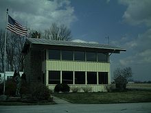
Darke County airport building. Building is used as a waiting area.
IATA: VESICAO: KVESFAA LID: VES
Summary
Airport type Public
Owner Darke County Commissioners
Location Versailles, Ohio
Elevation AMSL 1,007 ft / 307 m
Coordinates 40°12′16″N 84°31′55″W / 40.20444°N 84.53194°W / 40.20444; -84.53194Coordinates: 40°12′16″N 84°31′55″W / 40.20444°N 84.53194°W / 40.20444; -84.53194
Runways
Direction Length Surface
ft m
9/27 4,512 1,375 Asphalt
Source: FAA[1]

The Darke County Airport (IATA: VESICAO: KVESFAA LID: VES) is a general aviation public use airport located in Versailles, Ohio. It is along State Route 121 just south of Versailles. Midmark operates a private jet from this airport.

References

  1. ^ Airport information for KVES at World Aero Data. Data current as of October 2006.Source: FAA.. Retrieved on 2008-07-17.

External links


Wikimedia Foundation. 2010.

Игры ⚽ Поможем написать курсовую

Look at other dictionaries:

  • Darke — may refer to: Dark (alternate spelling) Darke County, Ohio Darke County Airport Darke Lake Provincial Park USS Darke (APA 159), US Navy Haskell class attack transport Darke (novel), the sixth book in the child fantasy Septimus Heap… …   Wikipedia

  • Ashland County (Ohio) — Ashland County Courthouse in Ashland, gelistet im NRHP mit der Nr. 79003786[1] Verwaltung …   Deutsch Wikipedia

  • Seneca County, Ohio — Coordinates: 41°08′N 83°08′W / 41.13°N 83.13°W / 41.13; 83.13 …   Wikipedia

  • Randolph County, Indiana — Infobox U.S. County county = Randolph Countystate = Indiana map size = 155 founded = 1818 seat = Winchester largest city = Winchester area total sq mi =453 area land sq mi =453 area water sq mi =0 area percentage = 0.09% census yr = 2000 pop =… …   Wikipedia

  • Ottawa County, Ohio — Location in the state of Ohio …   Wikipedia

  • Delaware County, Ohio — Location in the state of Ohio …   Wikipedia

  • Jackson County, Ohio — Location in the state of Ohio …   Wikipedia

  • Ohio State Route 242 — State Route 242 Route information Maintained by ODOT Length: 3.67 mi[1 …   Wikipedia

  • Greenville, Ohio — Infobox Settlement official name = Greenville, Ohio settlement type = City nickname = motto = image caption = Statue of Annie Oakley imagesize = 250px image mapsize = 250px map caption = Location of Greenville, Ohio mapsize1 = map caption1 =… …   Wikipedia

  • Greenville (Ohio) — Greenville …   Deutsch Wikipedia

Share the article and excerpts

Direct link
Do a right-click on the link above
and select “Copy Link”