- Pas de Peyrol
-
Pas de Peyrol 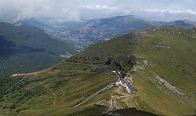
Pas de Peyrol looking north from Puy MaryElevation 1,589 m (5,213 ft) Traversed by D17/D680 Location Location of Pas de Peyrol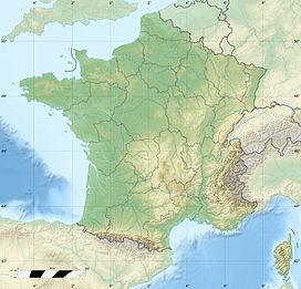
 Pas de Peyrol
Location Cantal,  France
Range Massif Central Coordinates 45°06′50″N 02°40′19″E / 45.11389°N 2.67194°ECoordinates: 45°06′50″N 02°40′19″E / 45.11389°N 2.67194°E Pas de Peyrol (el. 1,589 m) is a mountain pass located in Auvergne, France, and is the highest road pass in the Massif Central. The pass is on the slopes of Puy Mary (1,787 m) and is situated at the junction of three roads:
- D17 to the south-west towards Aurillac, via the Col de Redondet (1,531 m), then down the valley of the River Jordanne.
- D680 to the north-west towards Salers
- D680 to the east, towards Dienne, down the valley of the River Santoire
Contents
Tour de France
The pass is regularly used on the Tour de France, most recently on stage 9 of the 2011 tour. The pass was first used in the 1959 Tour de France, on the 231 km stage 14 from Aurillac to Clermont Ferrand, with Louis Bergaud first across the summit. In the 2004 tour, the pass was used on stage 10 from Limoges to Saint-Flour, approaching from the Salers direction which includes a final three kilometres at an average of 12% and a maximum gradient of 15%, with Richard Virenque first over the summit.
Appearances in the Tour de France
The Tour de France has crossed the summit 9 times since 1947, including on stage 9 of the 2011 tour. The 10th stage was selected for the 2004 L'Étape du Tour, in which amateur and club riders ride over a full stage of the tour.
Year Stage Category Start Finish Leader at the summit 2011 9 2 Issoire St Flour Thomas Voeckler 2008 7 2 Brioude Aurillac David de la Fuente 2004 10 1 Limoges St. Flour Richard Virenque 1985 15 2 Saint-Étienne Aurillac Eduardo Chozas 1983 14 2 Aurillac Issoire Lucien Van Impe 1975 14 3 Aurillac Puy-de-Dôme Lucien Van Impe 1968 17 3 Aurillac Saint-Étienne Aurelio Gonzalez 1963 14 3 Aurillac Saint-Étienne Federico Bahamontes 1959 14 2 Aurillac Clermont-Ferrand Louis Bergaud See also
- List of highest paved roads in Europe
- List of mountain passes
External links
Categories:- Mountain passes of France
- Cantal
- 2008 Tour de France
- Climbs in cycle racing


Wikimedia Foundation. 2010.