- Mellows Bridge
-
Mellows Bridge
Droichead Uí Mhaoilíosa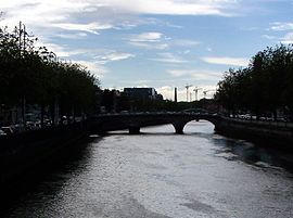
Other name(s) Mellowes Bridge Crosses River Liffey Locale Dublin Designer Charles Valency Design Elliptical arch stone bridge Total length 43m Width 10.2m Number of spans 3 Construction end 1764 Preceded by First built 1684 - Arran Bridge
Rebuilt 1764 - Queen's Bridge
Renamed 1923 - Queen Maev Br.
Renamed 1942 - Mellows BridgeCoordinates 53°20′47″N 6°16′50″W / 53.3464°N 6.2805°WCoordinates: 53°20′47″N 6°16′50″W / 53.3464°N 6.2805°W Mellows Bridge (Irish: Droichead Uí Mhaoilíosa[1]) is a road bridge spanning the River Liffey, in Dublin, Ireland and joining Queen Street and Arran Quay to the south quays.
In 1683,[2] a stone bridge called Arran Bridge or Arons Bridge was built in a location between the upstream Bloody Bridge (see Rory O'More Bridge) and the downstream Bridge of Dublin (see Fr. Mathew Bridge). Construction was funded by landowner William Ellis, and Dublin Corporation. It was named after Richard, Earl of Arran, second son of the Duke of Ormonde. From a drawing made by Francis Place in 1699, it appears to have been a four-span stone arched bridge.
It was also known as Bridewell Bridge[2] due to its proximity to the Smithfield Bridewell, and as Ellis's Bridge because of its association with Sir William and Sir John Ellis.
This structure stood for 80 years, but was swept away by a flood in 1763. The collapse was described by George Semple as being an unlucky accident when a raft of timber was swiftly carried downstream in a flood where it got lodged across the middle arch. The water flow increased under the raft at this point, and since the piers of the bridge were built on top of the river bed - This raft of timber obstructing the current of the surface, in like manner increased the power of it at the bottom and within the space of a few hours totally demolished the bridge.[3]
Designed by Charles Valency (a military engineer) a replacement bridge on the same site was built between 1764 and 1768[4] as a three elliptical arch stone bridge with a total span of 42 m, and named Queens Bridge after Charlotte of Mecklenburg, queen consort of George III.[2]
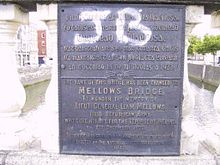
The bridge was renamed for the legendary Queen Maeve at a meeting of the Municipal Council on 2 January 1922. However, it was renamed again in 1942 to its current name, after Lieutenant General Liam Mellows Irish Republican army who was executed during the Irish Civil War.
At almost 250 years old, Mellow's Bridge remains the oldest of all Dublin city bridges still in use, although the parapets were replaced with cast iron balustrades and stone copings between 1816 and 1818.
Nomenclature
As with other bridges on the Liffey in Dublin, and largely because of the many name changes, Mellow's Bridge is known locally by several names, including: Queen's Bridge, Queen's Street Bridge, Queen Maeve Bridge, and Mellowes Bridge (with an "e").
References
- ^ Logainm.ie - Database of Placenames' Commission
- ^ a b c Archiseek - Queen Maeve/Mellows Bridge
- ^ The Liffey in Dublin, J.W. de Courcy, 1996, Gill and Macmillan, Dublin, ISBN 0 7171 2423 1
- ^ Mellows Bridge at Structurae
Bridges in Dublin over the Liffey (west to east) Lucan · West-Link · Farmleigh (Disused) · Anna Livia · Island · Liffey · Seán Heuston · Frank Sherwin · Rory O'More · James Joyce · Mellows · Father Mathew · O'Donovan Rossa · Grattan · Millennium · Ha'penny · O'Connell · Butt · Loopline · Talbot Memorial · Seán O'Casey · Samuel Beckett · East-Link
Categories:- Bridges in Dublin (city)
- Bridges completed in 1768


Wikimedia Foundation. 2010.