- Orestiada
-
For the eponymous lake, see Lake Orestiada.
Orestiada
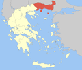
ΟρεστιάδαLocation Coordinates 41°30′N 26°32′E / 41.5°N 26.533°ECoordinates: 41°30′N 26°32′E / 41.5°N 26.533°E Government Country: Greece Region: East Macedonia and Thrace Regional unit: Evros Population statistics (as of 2001) Municipality - Population: 39,485 - Area: 967.5 km2 (374 sq mi) - Density: 41 /km2 (106 /sq mi) Municipal unit - Population: 21,730 Community - Population: 17,194 Other Time zone: EET/EEST (UTC+2/3) Elevation (center): 35 m (115 ft) Postal: 682 00 Telephone: 25520 Auto: OP Website www.orestiada.gr Orestiada (Greek: Ορεστιάδα, formerly Ὀρεστιάς, Orestiás) is the northeasternmost and northernmost city of Greece and the second largest city of the Evros peripheral unit of Thrace. The population is around 25,000. Orestiada is only 2 km west of the banks of the Evros, which forms a natural border between Greece and Turkey. Orestiada is located 23 km S of Edirne, about 64 km SE of the Greek-Turkish-Bulgarian border, 66 km SE of Svilengrad, about 110 km N of Alexandroupoli, N of Didymoteicho, ENE of Soufli, about 110 km ENE of Alexandroupoli and 460 km ENE of Thessaloniki.
GR-51/E85 once ran through Orestiada, which today is bypassed 1 km to the west.
It is a modern and contemporary city, only 75 years old. In ancient times, there was a small settlement on this site which legends claim was founded by Orestes, the son of Agamemnon and Clytemnestra. Ancient Orestiada was located in present day Turkey, across the river from the town of Kastanies. Nea Orestias or New Orestiada was founded in 1922 when the population exchange occurred between Turkey and Greece, in which the Evros River became the new border between the two countries. The site of the original Orestiada was founded around 3000 years ago and remains fairly undeveloped as it is near the much larger city of Edirne.
Orestiada has a train station, a Medical Centre, a Philharmonic and a Choir as well as a sugar factory, outside the city which processes locally grown sugar beets. Asparagus, potatoes, tobacco, watermelons and corn are also grown. As well, a cattle breeding fund gives commercial impetus to the city and the whole area which is in such an economically strategic location in Europe.
It is also the site of the Fylakio detention center for illegal immigrants. In November 2010, the European Union sent Frontex forces to Orestiada to help Greek police patrol the local section of the border with Turkey. Some 31,400 people crossed just that portion of the border in the first nine months of 2010.[1]
In 1999, Orestiada became the fourth city to host university departments (faculties) of the Democritus University of Thrace. The faculties based in Orestiada are the Department of Rural Development and the Department of Forestry, Environmental Management and Natural Resources. Both faculties have a five year curriculum. More than 800 students live in the city.
Contents
Municipality
The municipality Orestiada was formed at the 2011 local government reform by the merger of the following 4 former municipalities, that became municipal units:[2]
Communities
The municipal unit Orestiada is subdivided into the following communities (constituent settlements in brackets):
- Orestiada (Orestiada, Lepti, Neos Pyrgos, Palaia Sagini, Sakkos)
- Ampelakia
- Chandras
- Megali Doxipara
- Neo Cheimonio
- Neochori (Neochori, Patagi)
- Thourio
- Valtos
Population
Year Population town Population municipal district Population municipality 1981 14,727 - - 1991 12,691 - 19,669 2001 15,246 17,194 21,862 The population of the settlements within the municipal district Orestiada at the 2001 census was:
- Orestiada 15,246
- Lepti 793
- Neos Pyrgos 894
- Palaia Sagini 13
- Sakkos 248
See also
- Communities of the Evros prefecture
- Lefteris Hapsiadis Popular Song Orestiada
References
- ^ "Ailing Greece Struggles with a Flood of Illegal Immigrants". Yahoo News. 17 December 2010. http://news.yahoo.com/s/time/20101217/wl_time/08599203743300. Retrieved 17 December 2010.
- ^ Kallikratis law Greece Ministry of Interior (Greek)
Northwest: Kyprinos North: Vyssa West: Kyprinos and Metaxades Orestiada East: Turkey Southwest: Metaxades South: Didymoteicho Municipal unit of Orestiada Municipal unit of Trigono Municipal unit of Vyssa Administrative division of the East Macedonia and Thrace Region Regional unit of Drama Regional unit of EvrosRegional unit of KavalaRegional unit of RhodopeRegional unit of ThasosRegional unit of XanthiRegional governor: Aristeidis Giannakidis · Website: www.pamth.gov.grCategories:
- Populated places in Evros (peripheral unit)
- Municipalities of East Macedonia and Thrace
Wikimedia Foundation. 2010.


