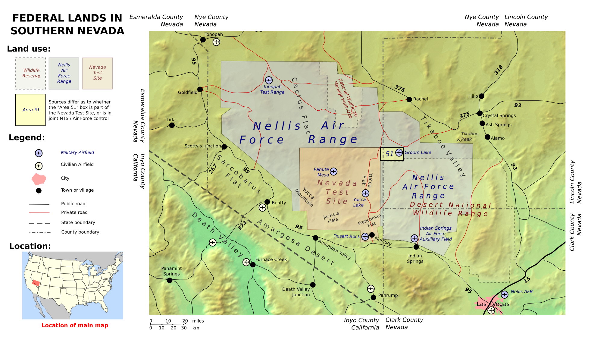
- Nevada State Route 375
-
State Route 375
Extraterrestrial Highway, Warm Springs Road 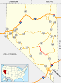
Route information Maintained by NDOT Length: 98.414 mi[1] (158.382 km) Existed: 1976 – present History: SR 25 by 1933; became SR 375 in 1976; highway named in 1996. Major junctions South end:  SR 318 at Crystal Springs
North end:  US 6 at Warm Springs
Highway system ←  SR 374
SR 376  →
→State Route 375 (SR 375) is a state highway in south-central Nevada in the United States. The highway stretches 98 miles (158 km) from State Route 318 at Crystal Springs northwest to U.S. Route 6 (US 6) at Warm Springs. The route travels through mostly unoccupied desert terrain, with much of its alignment paralleling the northern edges of the Nellis Air Force Range. The road originally traversed through what is now the northern reaches of the air force range in the 1930s, when it was previously designated State Route 25A and later part of State Route 25.
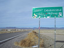
The top-secret Area 51 government base is near SR 375 and many travelers have reported UFO observations and other strange alien activity along this road. Such stories prompted the state to officially designate the route as the Extraterrestrial Highway in 1996. The small town of Rachel, located near the center of the highway, caters to tourists and UFO seekers with alien-themed businesses. Although the area receives some tourism due to alleged extraterrestrial activity, SR 375 remains a lightly traveled route.
Contents
Route description
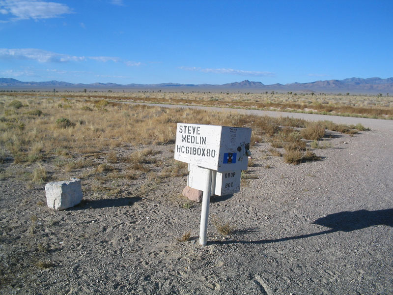
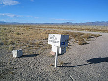 The so-called "black mailbox"
State Route 375 begins at a "Y" junction with State Route 318 at Crystal Springs, a ghost town in the northern end of the Pahranagat Valley in the center of Lincoln County. The site, which is little more than the junction and a few trees, functions as a rest area.[2] From Crystal Springs, the highway curves southwest to pass between the Pahrangat and Golden Gate Ranges to ascend 5,592-foot (1,704 m) Hancock Summit.[2]
Descending the summit, SR 375 nears the border of the Nellis Air Force Range. As the highway heads northwest through Tikaboo Valley, it meets Mail Box Road. Marked by a single postal drop known as the "black mailbox", the dirt access road leads to the restricted lands surrounding Area 51. The mailbox, which is no longer black, is commonly used as a gathering place for UFO seekers,[3] and two to three UFO sightings per week allegedly occur in the area.[4] SR 375 continues heading northwest from the mailbox, climbing in elevation again to reach the top of Coyote Summit at 5,591 feet (1,704 m).[2]
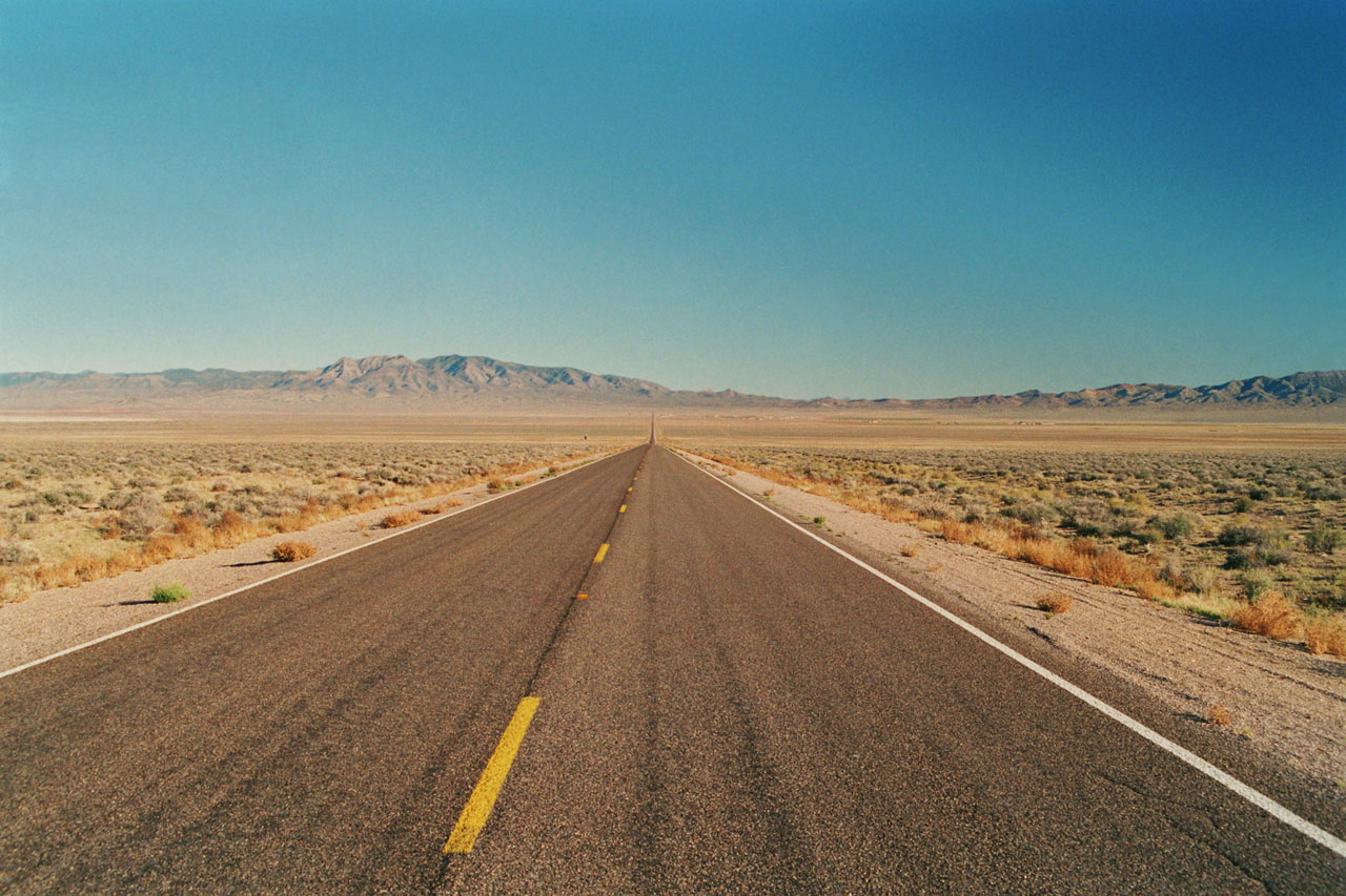
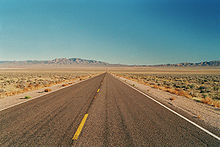 SR 375 passing through Sand Spring Valley
West of the summit, the Extraterrestrial Highway descends into the Sand Spring Valley and the community of Rachel becomes visible. The small town of about 100 residents is little more than homes and a few businesses. The Little A'Le'Inn (pronounced "alien") is the focal point of the town, providing a small motel, an alien-themed restaurant/bar, and extraterrestrial souvenirs.[4][5] The civilian-run Area 51 Research Center, based out of a yellow house trailer[6] and documenting paranormal activity in the area, closed in 2001.[4][7]
Leaving Rachel, SR 375 continues northwest to enter Nye County. The route climbs out of Sand Spring Valley and heads over the 5,935-foot (1,809 m) Queen City Summit, the highest point on the highway.[2] After passing the summit, the route descends into the southern end of Railroad Valley, curving nearly due north for several miles as it follows the base of Reveille Range. As the mountains subside, the road turns westward again to head to its northern terminus at the junction of US 6 at Warm Springs.[2]
History
Route development
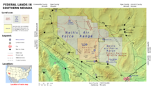 Map showing the location of Rachel, and State Route 375 as it passes north of Area 51.
 SR 375 originated as State Route 25A and later became the western segment of State Route 25.
An unimproved road approximating the present alignment of State Route 375 came into existence by 1932. This route, christened State Route 25A, connected Crystal Springs to State Route 4 (now US 6) just east of Tonopah.[8] By 1933, SR 25A had been renumbered to become a new western segment of State Route 25.[9] The route underwent periodic realignments over the next few years, but the highway's terminal junctions remained mostly unchanged.
In 1942, SR 25 appeared to have a significant gap in its route. State maps from the time show a large area within Nye and Lincoln Counties where all roads had been removed.[10] The route existed in one piece again by 1946, although it had been realigned northward and shortened to 111 miles (179 km).[11] A sizable portion of SR 25 passing through the Tonopah U.S. Army Air Force Bombing Range (now the Nellis Air Force Range and Nevada Test Site) was restricted from public travel by 1950, the restricted section being approximately the same area that was removed in 1942.[10][12] To avoid the restricted area of the testing range, the west end of SR 25 was realigned by 1957. The highway connected to US 6 at Warm Springs about 37 miles (60 km) east of the previous terminus, heading north around the Reveille Range instead of climbing the Kawich Range within the bombing area.[13]
With the 1957 realignment, the routing of SR 25 attained its final form. The entire highway was paved by the following year.[14] SR 25 remained unchanged until the 1976 renumbering of Nevada's state highways, through which the western section of SR 25 became the new State Route 375.[15] The new route number was first seen on the 1978 edition of the official state highway map.[16]
Naming the highway
In 1989, a man claiming to have worked on alien spaceships and have viewed saucer test flights in Tikaboo Valley told his story to a Las Vegas television station.[3] By the 1990s, stories of the top-secret U.S. government base at Area 51 had become mainstream, and many books and personal accounts had been published regarding extraterrestrial spacecraft and alien activity in the region surrounding Groom Lake. Rachel, being the closest settlement to the restricted facility, attracted people in search of UFOs and alien life.[17] To capitalize on the purported paranormal activity along the route, the Nevada Commission on Tourism sought to rename the highway. State officials drew inspiration from the alien legends and dubbed SR 375 the Extraterrestrial Highway in February 1996.[18] The tourism commission hoped that the renaming would "draw travelers to the austere and remote reaches of south-central Nevada, where old atomic bomb test sites, secret Defense Department airstrips and huge, sequestered tracts of military land create a marketable mystique."[5]
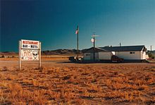 The Little A'Le'Inn in Rachel benefits from tourism brought by the renamed highway.
News of the highway's renaming reached Twentieth Century Fox. The studio used the opportunity to promote the release of its upcoming film Independence Day, whose plot involves an alien invasion of Earth and the secret facility at Area 51. A public dedication ceremony for the Extraterrestrial Highway was held in Rachel on April 18, 1996.[19] State dignitaries at the ceremony were joined by studio executives and Independence Day stars Jeff Goldblum, Robert Loggia, Bill Pullman, and Brent Spiner.[19][20] Nevada Governor Bob Miller presided over the ceremony, speaking with humorous space references and unveiling special "Extraterrestrial Highway 375" and "Speed Limit Warp 7" signs for the highway.[20] The event concluded with several guests placing items related to Nevada and the film into a time capsule commemorating the occasion.[19][20]
To promote the Extraterrestrial Highway after its renaming, the tourism commission launched "The ET Experience" in July of 1996. Tourists could contact the Nevada Commission on Tourism to receive a traveler's kit containing information about the highway, nearby cultural attractions, and area services. Visitors that patronized businesses in Rachel and central Nevada and submitted an account of their journey received Extraterrestrial Highway memorabilia. Stories from travelers were also published in a newsletter available to those that had completed the experience.[18] Despite tourism generated by people searching for signs of alien life, only "an average of about 200 cars drive some portion of the Extraterrestrial Highway every day, making it one of the state’s least traveled routes."[5]
Major intersections
 Looking northwest near Rachel, visitors have left their marks on the Extraterrestrial Highway.
- Note: Mileposts in Nevada reset at county lines; the start and end mileposts for each county are given in the county column. This table presents junctions south to north as SR 375 is signed, although the highway's mileposts are assigned west to east.
County Location Mile[1] Destinations Notes Lincoln
49.05–0.00Crystal Springs 49.05  SR 318 to US 93
Southern terminus Nye
49.36–0.00Warm Springs 0.00 US 6 – Tonopah, ElyNorthern terminus 1.000 mi = 1.609 km; 1.000 km = 0.621 mi See also
- State Route 319, the eastern segment of former State Route 25
References
- ^ a b "State Maintained Highways of Nevada: Descriptions and Maps - Quarter 2 Update". Nevada Department of Transportation. July 2011. http://www.nevadadot.com/Documents/State_Maintained_Highways,_Descriptions,_Index___Maps.aspx. Retrieved 20 July 2011.
- ^ a b c d e Nevada Department of Transportation (2007). Official Highway Map of Nevada (Map) (2007–08 ed.). Section D4,E4,E5.
- ^ a b Powers, Ashley (August 21, 2008). "In the Nevada desert, there's something out there -- the Black Mailbox". Los Angeles Times. http://articles.latimes.com/2008/aug/21/nation/na-mailbox21. Retrieved 2009-08-21.
- ^ a b c Zekan, Karen (April 30, 1999). "The ‘X’ Miles". Las Vegas Sun. http://www.lasvegassun.com/news/1999/apr/30/the-x-miles/. Retrieved 2009-01-13.
- ^ a b c Regenold, Stephen (April 13, 2007). "Lonesome Highway to Another World?". The New York Times. http://travel.nytimes.com/2007/04/13/travel/escapes/13extraterrestrial.html?ex=1334116800&en=166686097a86d459&ei=5090&partner=rssuserland&emc=rss. Retrieved 2009-01-13.
- ^ "Area 51 Research Center". The Center for Land Use Interpretation. http://ludb.clui.org/ex/i/NV3167/. Retrieved 2009-04-25.
- ^ "Rachel, Nevada". Official Homepage of Rachel, Nevada. March 12, 2007. http://www.rachel-nevada.com/rachel.html. Retrieved 2009-04-25.
- ^ Nevada Department of Highways (1932). Road Map (Map). 1" = 20 mi. http://contentdm.library.unr.edu/u?/hmaps,459. Retrieved 2009-04-10.
- ^ Nevada State Highway Department (1933). Official Road Map of Nevada (Map). http://contentdm.library.unr.edu/u?/hmaps,461. Retrieved 2009-04-10.
- ^ a b Nevada Department of Highways (1942). Official Road Map of the State of Nevada (Map). http://contentdm.library.unr.edu/u?/hmaps,477. Retrieved 2009-04-10.
- ^ Nevada Department of Highways (1946). Official Road Map of the State of Nevada (Map). http://contentdm.library.unr.edu/u?/hmaps,479. Retrieved 2009-04-10.
- ^ Nevada Department of Highways (1950). Official Highway Map of Nevada (Map). Section F4-G6. http://contentdm.library.unr.edu/u?/hmaps,487. Retrieved 2009-04-11.
- ^ Nevada Department of Highways (1957). Official Highway Map of Nevada (Map). Section F4-G6. http://contentdm.library.unr.edu/u?/hmaps,3056. Retrieved 2009-04-11.
- ^ Nevada Department of Highways (1958). Official Highway Map of Nevada (Map). Section F4-G6. http://contentdm.library.unr.edu/u?/hmaps,505. Retrieved 2009-04-11.
- ^ Nevada State Maintained Highways: Descriptions, Index and Maps. Nevada Department of Transportation. January 2001. p. 112.
- ^ Nevada State Highway Department (1978). Official Highway Map of Nevada (Map) (1978-79 ed.). Section D4,E4,E5. http://contentdm.library.unr.edu/u?/hmaps,535. Retrieved 2009-04-11.
- ^ Moreno, Richard (2000). Roadside History of Nevada. Missoula: Mountain Press Publishing Company. pp. 91–92. ISBN 0-87842-410-5.
- ^ a b "Tourism Commission has really gone far out there". Las Vegas Sun. July 5, 1996. http://www.lasvegassun.com/news/1996/jul/05/tourism-commission-has-really-gone-far-out-there/. Retrieved 2009-01-13.
- ^ a b c "Nevada Dedicates Extraterrestrial Highway". Las Vegas Leisure Guide. January 9, 1997. http://www.pcap.com/extrater.htm. Retrieved 2009-01-13.
- ^ a b c Manning, Mary (April 19, 1999). "Rural highway out of this world". Las Vegas Sun. http://www.lasvegassun.com/news/1996/apr/19/rural-highway-out-of-this-world/. Retrieved 2009-01-13.
External links
- Extraterrestrial Highway Home Page, includes photos and many useful links
- Extraterrestrial Highway @ National Scenic Byways Program
- Extraterrestrial Highway @ Vegas.com, includes short video preview
- The Extraterrestrial Highway @ Roadtrip America
Categories:- State highways in Nevada
- Transportation in Nye County, Nevada
- Transportation in Lincoln County, Nevada


Wikimedia Foundation. 2010.