Ollerton (disambiguation) — Ollerton is a town in the English county of Nottinghamshire. New Ollerton is nearby Additionally Ollerton can refer to the settlements of: Ollerton, Cheshire Ollerton, Shropshire Ollerton Fold, Lancashire This disambiguation page lists articles… … Wikipedia
Ollerton — Recorded in the spellings of Allerton, and occasionally Ollerton, this is an English surname. It is locational from any of the various places so called including Allerton in Lancashire, Chapel Allerton in the West Riding of Yorkshire, and… … Surnames reference
List of places in Shropshire — This is a list of towns and villages in the ceremonial county of Shropshire, England. This list includes those places in Telford and Wrekin. See the list of places in England for places in other counties.The five major towns in the county… … Wikipedia
List of air stations of the Royal Navy — This is a list of Naval Air Stations of the Royal Navy. Naval Air Stations are military airbases, and consist of permanent land based operations locations for the military aviation division of the Royal Navy, namely the Fleet Air Arm.=Current… … Wikipedia
Child's Ercall — St Michael s Church, Child s Ercall Coordinates … Wikipedia
Minshull Vernon — Coordinates: 53°08′24″N 2°28′23″W / 53.14°N 2.473°W / 53.14; 2.473 … Wikipedia
Cholmondeston — Coordinates: 53°08′N 2°34′W / 53.13°N 2.56°W / 53.13; 2.56 … Wikipedia
Nottinghamshire County Council election, 2009 — Conservative … Wikipedia
Coole Pilate — Typical flat farmland in Coole Pilate Coole Pilate is a civil parish in the unitary authority of Cheshire East and the ceremonial county of Cheshire, England, which lies to the north of Audlem and to the south of Nantwich. The area is… … Wikipedia
Civil parishes in Cheshire — A map of Cheshire, showing the Boroughs : (1) Cheshire West and Chester; (2) Cheshire East; (3) Warrington; and (4) Halton. A civil parish is a subnational entity, forming the lowest unit of local government in England. There are 332 civil… … Wikipedia
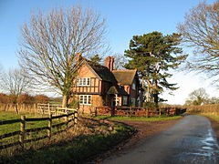 Lodge house for Peplow Hall, Ollerton.
