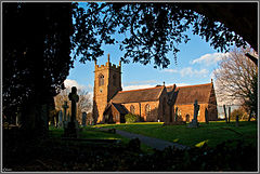
- Child's Ercall
-
Coordinates: 52°49′19″N 2°29′42″W / 52.822°N 2.495°W Child's Ercall is a village and civil parish in Shropshire, England. It is located in a rather remote rural area between the small towns of Market Drayton and Newport: the civil parish had a total population of 599 at the 2001 census.[1] The closest neighbouring village is Ollerton, around 1 mile to the west.
Its name is thought to derive from a Celtic word, perhaps the old Welsh name Ercal,[2] along with "child" in its mediaeval sense, meaning "knight".[3] The parish is sometimes referred to as Ercall Parva, which turned into "Little Ercall". This name saved it from confusion with the other Ercall in Shropshire - Ercall Magna, now called "High Ercall". The change from use of the names Ercall Magna and Ercall Parva to High Ercall and Little and later Child's Ercall, pbetter suggests that the use of the term "Child's" merely alludes to it being 'Little' like a child, compared to the 'adult' High(er) Ercall, rather than any link to a term for a young knight.
The village church has a 12th century doorway, a 13th century arcade and 14th century aisle, as well as stained glass by Charles Eamer Kempe.[3]
References
- ^ Child's Ercall CP, Office of National Statistics
- ^ Gelling, M. The place-names of Shropshire, pt.1, English Place-Name Society, 1990, pp.125-6
- ^ a b Raven, M. A Guide to Shropshire, 2005, p.50
External links
 Media related to Child's Ercall at Wikimedia Commons
Ceremonial county of Shropshire Boroughs or districts Major settlements Bishop's Castle • Bridgnorth • Broseley • Church Stretton • Cleobury Mortimer • Clun • Craven Arms • Ellesmere • Ludlow • Market Drayton • Much Wenlock • Newport • Oswestry • Shifnal • Shrewsbury • Telford (Dawley • Madeley • Oakengates • Wellington) • Wem • Whitchurch
See also: List of civil parishes in ShropshireRivers Topics Categories:- Civil parishes in Shropshire
- Villages in Shropshire
- Shropshire geography stubs
Wikimedia Foundation. 2010.

