Hurlstone Park railway station, Sydney
- Hurlstone Park railway station, Sydney
Cityrail Station alt|station_name=Hurlstone Park|
servicearea=Bankstown Line|servicearea_color=#Bankstown line colour|servicearea_textcolor=black
code=HPK|suburb=Hurlstone Park|street=Floss St|distance=8.80|altitude=?|traintype=Suburban all stops|platforms=2|tracks=4|platform_arr=2 Side|stationtype=Ground|gates=?|connect=Bus|disabled=No
facilities= [http://www.cityrail.info/facilities/facilities.jsp?n=131&giveOutput=true&facility= Link]
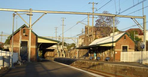
Hurlstone Park is a CityRail railway station on Sydney's Bankstown line. Located in the suburb of Hurlstone Park, it serves a residential area. It has two side platforms. There are also 2 tracks for goods trains.
Platforms/Service
The station is served by 4 trains per hour in both directions. There are additional trains in peak hours, and trains every half hour late in the evenings, and on the weekends.
Platform 1:
*Bankstown line alt - all stations services to the City Circle.
Platform 2:
*Bankstown line alt - all stations services to Lidcombe or Liverpool via Bankstown.
Accessibility
The station has street access to both platforms via stairs. This does not allow for Easy Access for wheelchairs.
Gallery
ee also
*Railways in Sydney
*CityRail
*Metropolitan Goods Line
Neighbouring stations
Wikimedia Foundation.
2010.
Look at other dictionaries:
Dulwich Hill railway station, Sydney — Cityrail Station alt station name=Dulwich Hill servicearea=Bankstown Line servicearea color=#Bankstown line colour servicearea textcolor=black code=DHM|suburb=Dulwich Hill street=Wardell Rd|distance=7.87|altitude=? traintype=Suburban all stops… … Wikipedia
Summer Hill railway station, Sydney — Cityrail Station alt|station name=Summer Hill| servicearea=Inner West Line|servicearea color=#Inner West line colour|servicearea textcolor=white code=SMH|suburb=Summer Hill|street=Carlton Cres Grosvenor… … Wikipedia
Hurlstone Park, New South Wales — Infobox Australian Place | type = suburb name = Hurlstone Park city = Sydney state = nsw caption = Crinan Street, Hurlstone Park lga = City of Canterbury lga2 = Municipality of Ashfield postcode = 2193 pop = 5,013 (2001 census) stategov =… … Wikipedia
Ashfield railway station, Sydney — Ashfield railway station is a station located on the Inner West line of the CityRail network. It is located in the Sydney suburb of Ashfield and was opened in 1855 as part of the original Sydney to Parramatta railway line. It features five… … Wikipedia
Dulwich Hill railway station — Dulwich Hill … Wikipedia
Hurlstone Agricultural High School — Infobox School name = Hurlstone Agricultural High School imagesize = caption = location = streetaddress = region = city = Glenfield state = NSW district = province = county = postcode = postalcode = zipcode = country = Australia coordinates =… … Wikipedia
Trams in Sydney — This is a historical article about the now closed tramways of Sydney. For the current light rail line, see Metro Light Rail. Sydney, the largest city in Australia, once had the largest tram system in Australia, the second largest in the… … Wikipedia
Bus routes in Sydney — Bus routes in Sydney, Australia are numbered with three digits, the first digit referring to the region in which the bus route primarily operates.Northern BeachesBus services between the Northern Beaches region of Sydney and the central business… … Wikipedia
Croydon Park, New South Wales — Croydon Park Sydney, New South Wales Croydon Park Hotel Population … Wikipedia
Earlwood, New South Wales — Infobox Australian Place | type = suburb name = Earlwood city = Sydney state = nsw caption = Earlwood Hotel, Homer Street lga = City of Canterbury postcode = 2206 pop = area = propval = est = stategov = Canterbury fedgov = Watson near nw =… … Wikipedia