- San Esteban, Nabua, Camarines Sur
-
This article is about the barangay of Nabua, Camarines Sur. For other uses, see San Esteban.
San Esteban, Nabua, Camarines Sur — Barangay — 
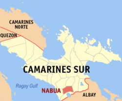
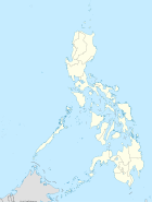
FlagMap of Camarines Sur showing the location of Nabua Location in the Philippines Coordinates: 13°24′05″N 123°22′35″E / 13.40139°N 123.37639°ECoordinates: 13°24′05″N 123°22′35″E / 13.40139°N 123.37639°E Country Philippines Region Bicol Region
(Region V)Province Camarines Sur Municipality Nabua Zones 8 Established (as settlement) July 28, 1569 Government – Barangay Chairman Romeo J. Quidep Population (2000) – Total 1,818 Time zone PST (UTC+8) Symbols of San Esteban Name San Esteban Flag 
Dance Jota Rojana Bird Kusta Fish Pampano Flower Euphorbia Tree Noyog Plant Katnga Fruit Mango Hero Datu Ogbon San Esteban is a barangay in Antacudos district of Nabua, Camarines Sur in the Philippines.[1] In 1569, when the Philippines was still a colony of Spain, San Esteban was a part of Rancheria Antacudos of Bua, which was the name of Nabua at that time.[citation needed] The other rancherias were Caobnan, Sabang, Lupa and Binoyoan.
Before the Spaniards came, Nabua was ruled by a Muslim Chieftain named Datu Ogbon.[citation needed] Several barangays of Nabua carry his name, such as San Vicente Ogbon and San Antonio Ogbon, among others.
Contents
Government
The seat of government is located in Likod North.[citation needed] The government center, main police outpost, day care center, youth center and parish chapel are all located here. The health center, however, is located in Likod South. The plaza is situated in Centro Uno. Police outposts are also located in Cabuntaran and Magol West. The current barangay chairman is Romeo Julia Quidep of Magol East.[citation needed]
Flag
The flag of San Esteban, called the "The Steven's Flag", features eight yellow stars on a blue field. At its center are white Star and crescent on a black background. On the upper left part is an orange Greek cross.
The eight yellow stars refers to the eight zones of San Esteban: Centro North, Centro South, Likod North, Likod South, Cabuntaran, Magol East, Magol West and Folklands. The star and crescent and orange Greek cross represent the Muslim and Christian citizens of the community. The blue background symbolizes the peaceful co-existence among the people of San Esteban.
The Steven's Flag was the second community flag used in Nabua after the Blue flag was replaced by the former.[citation needed]
People
Nabueño is the official language of San Esteban.[citation needed] Other languages spoken are English, Tagalog and Bikol. As of August 2007, San Esteban had 1,818 inhabitants. The majority of the population is concentrated in the capital, Likod North. The barangay has an electorate of 996 voters.
Economy
Many of the barangay's business establishments such as the fish bagsakan, barber shop, jewelry pawnshop and videoke stalls are located in Centro Uno.
Religion
Many of the inhabitants are Roman Catholics. Other religions include Protestantism (Iglesia ni Cristo, Born Again, Mormons, Jehovah's Witnesses) and Islam.
The Nabua Parish Church is located in Centro North. Catholic Chapels are also situated in Likod North and Cabuntaran zones.
Organizations
San Esteban Young Achievers Council (SEYAC) is the leading and most active youth organization in San Esteban and in Nabua as a whole.
Other organizations include:
- San Esteban Youth Organization (SEYO)
- Ang Maogmang Grupo
- Holy Rosary Group
- San Esteban Rabus Organization
- Pastoral Council Organization
- Married Set Organization
Zones
- Centro North (Zone 1)
- Centro South (Zone 2)
- Likod North (Zone 3)
- Likod South (Zone 4)
- Cabuntaran (Zone 5)
- Magol East (Zone 6)
- Folklands (Zone 7)
- Magol West (Zone 8)
References
- ^ "Town of Nabua - Barangays". http://www.townofnabua.net/barangays.html. Retrieved 2008-04-30.
Categories:- Barangays of the Philippines
Wikimedia Foundation. 2010.


