- Campos Novos
Infobox City
official_name = Campos Novos, SC
nickname = "Granary of Santa Catarina"
motto =
imagesize = 250px
image_caption =
image_
mapsize = 250px
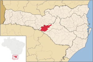
map_caption = Location of Campos Novos
subdivision_type = Country
subdivision_type1 = Region
subdivision_type2 = State
subdivision_name = flagicon|BRABrazil
subdivision_name1 = South
subdivision_name2 = flagicon|Santa Catarina Santa Catarina
leader_title = Mayor
leader_name = Nelson Cruz
leader_party = PMDB
leader_title1 = Vice Mayor
leader_name1 = Cirilo Rupp (PMDB)
leader_title2 =
leader_name2 =
leader_title3 =
leader_name3 =
established_title = Founded
established_date =March 30 ,1881
established_title2 =
established_date2 =
established_title3 =
established_date3 =
area_magnitude =
area_total_km2 = 1659.625
area_total_sq_mi =
area_land_km2 =
area_land_sq_mi =
area_water_km2 =
area_water_sq_mi =
area_water_percent =
area_urban_km2 =
area_urban_sq_mi =
area_metro_km2 =
area_metro_sq_mi =
pushpin_
population_as_of = 2008
population_note =
population_total = 28447
population_density_km2 = 17.14
population_density_sq_mi =
population_metro =
population_footnotes =
population_density_metro_km2 =
population_density_metro_sq_mi =
population_urban =
timezone =UTC-3
utc_offset = -3
timezone_DST =UTC-2
utc_offset_DST = -2
latd=27 |latm=24 |lats=07 |latNS=S
longd=51 |longm=13 |longs=30 |longEW=W
elevation_m = 946.7
elevation_ft =
postal_code_type =
postal_code =
blank_name = HDI (2000)
blank_info = 0.794 – high
website = [http://www.camposnovos.sc.gov.br www.camposnovos.sc.gov.br]Campos Novos is a
city in Santa Catarina, in the Southern Region ofBrazil . Campos Novos is a pioneer in production of pollen and the biggest grain and oat producer of Santa Catarina.The municipality invests also into fatstock and poultry farming.Main ethnic origins are Italian, German, Portuguese, Japanese, African.
History
The
Kaingang , an Indigenous people of southern Brazil, were the first habitants of the region.The construction of the railway
São Paulo -Rio Grande do Sul and the passages of the cattle drovers in the region mobilized many immigrants. Those migrations caused the creation of many villages at theRio de Peixe river, likeBom Retiro ,Capinzal andVideira . The arrival of the Italian and German settlers induced commercial and industrial activities in the XIX and XX century.Therefore the city has a rich cultural diversity. It has even a comunity of descendents of African slaves.
XIX century
As many of the municipalities in the region, Campos Novos populated from the first attempts of colonialisation in southern Brazil, which began between 1825 and 1830, as the farmer João Gonçalves de Araújo coming from
Curitibanos settled down in the region. Shortly afterwards came the gaúchos evaiding theWar of the Farrapos . Many farmers originating fromLages settled down as well, attracted by the huge quantity of terra and grassland. Then, the locality welcomed habitants coming from the states São Paulo and Paraná on the search of territory for cattle breeding.In 1854, Campos Novos became a district of the municipality of "Nossa Senhora dos prazeres de Lages", today
Lages , with a total area of more than 5 000 km², according to provincial law nº 377, ofJune 16 , 1854. Despite the many partitionings, Campos Novos is still one of the biggest municipality of Santa Catarina regarding the surface area.From 1869 until 1881, Campos Novos was under control of
Curitibanos . Then it became an independent municipality, according to provincial law nº 923, ofMarch 30 , 1881. Between 1850 and 1895, the province of Santa Catarina had only 11 municipalities.XX century
In the beginning of the XX century, Campos Novos was embossed by the construction of the railway
São Paulo -Rio Grande do Sul and by theContestado War . From 1908 until 1910 many immigrants of various nationions arrived in Campos Novos: Poland, Russia, Lebanon as well as other settlers from other Brazilian states, especially descendants from Germany and Italyafter theContestado War (1912-1916).Geography
Campos Novos is 370 km east of
Florianópolis , the capital of Santa Catarina.It is at the crosspoint of the federal highways BR-470 and BR-282 and the state highways SC-455 and SC-458.
Campos Novos has a central bus station with connections to
Curitiba ,Joinville ,Chapecó and many other cities.The next airports are in
Chapecó (XAP) 155 km,Lages (LAJ) 145 km,Concórdia (SSCK) 95 km,Videira (SSVI) 55 km,Joaçaba (SSJA) 40 km. [ [http://www.sol.sc.gov.br/santur/LocalAero.asp Airports in Santa Catarina] ]The municipality is divided into following 7 districts since 2007:
* Campos Novos
* Bela Vista
* Dal`Pai
* Espinilho
* Ibicuí
* Leão
* TupitingaEconomy / Industry
Campos Novos is the biggest grain producer of Santa Catarina. Many farmers are joined in cooperatives. There are also livestock and poultry farming
30 km from the city center, there is the occident's highest dam of that type with a height of 202 m. It was built from Aug 2001 to July 2006 by Enercan [ [http://www.enercan.com.br Enercan] ] . The 3 installed
Francis Turbine s have a power of 880 MWatts. TheCampos Novos Dam produces 3.310.404 MWh per year.Tourism
The museum Fundação Cultural Camponovense (Campos Novos cultural foundation) better known as Casa da Cultura (house of the culture) exposes the historic archive of Dr. Waldemar Rupp and the Testament from 1877, related to the history of the community in the XIX century.
The church São João Batista on the Lauro Müller square is decorated by wooden sculptures and beautiful stained glass.
22 km from the city center is the Ibicui district, better known as Corredeira, where descendents of African slaves live. There is also the cemetery Invernada dos Negros.
External links
[http://www.sc.gov.br/portalturismo/Default.asp?CodMunicipio=245&Pag=1 Municipalities of Santa Catarina] - in portuguese [http://www.fecam.org.br/municipios/index.php?cod_municipio=177 information from FECAM] - in portuguese

Wikimedia Foundation. 2010.