- Jutland Peninsula
-
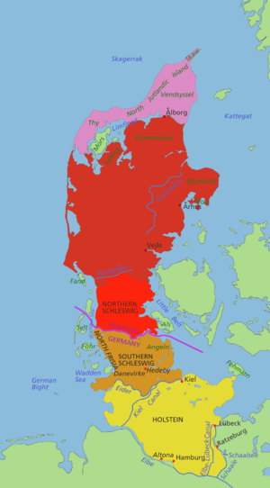
Red: The Danish part of Jutland. Brown: Southern Schleswig, historically a part of Jutland Region, although now in Germany. Yellow: Holstein, not part of Jutland Region, also Germany.

The Jutland Peninsula (Danish: Den Jyske Halvø German: Die Jütische Halbinsel) or more historically the Cimbrian Peninsula (Danish: Den Kimbriske Halvø German: Die Kimbrische Halbinsel) is a peninsula in Europe, divided between Denmark and Germany. The names are derived from the Jutes and the Cimbri.
The historic region of Jutland, the area that was covered by Codex Holmiensis (Jyske Lov) covered the Jutland Peninsula area north of Eider River and included Funen, the North Jutlandic Island and other smaller islands. Much of the varying definitions of what Jutland consists of are due to differences between the Jutland peninsula considered as a geographic feature and Jutland considered as a historical political territory.
Its terrain is relatively flat, with heaths, plains and peat bogs in the west and a more elevated and slightly hilly terrain in the east.
Subregions
North Jutlandic Island; part of Jutland Region, it was separated from the rest of the Jutland Peninsula in a flood in 1825.Northern Schleswig (Amt Sønderjylland, South Jutland County (until 2006), Nordslesvig; Danish since 1920; German from 1864 until 1920; Southern Jutland in a narrow sense.)Historical area of Holstein, sometimes considered part of Jutland Peninsula - north of the rivers Elbe, Bille and Trave.Northern Schleswig and Southern Schleswig form the historic region Southern Jutland (Sønderjylland). The Duchy of Schleswig covered almost the same area.
Northern Schleswig until 2006 was South Jutland County.
Geography
Its terrain is relatively flat, with heaths, plains and peat bogs in the west and a more elevated, fertile and slightly hilly terrain in the east. The Danish portion has an area of 29,775 km2 (11,496 sq mi) and a population of 2,513,601 (2007). Population density is 84 per km² (218 per sq.mi.).
The northernmost part of Jutland is separated by the Limfjord from the mainland, but is still commonly reckoned as part of the peninsula. It only became an island following a flood in 1825. The area is called the North Jutlandic Island, Vendsyssel-Thy (after its districts) or simply Jutland north of the Limfjord; it is only partly coterminous with the region called North Jutland.
The islands Læsø, Anholt and Samsø in Kattegat and Als at the rim of the Baltic Sea South are administratively and historically tied to Jutland, although especially the latter two are also regarded traditional districts of their own. Inhabitants of Als would agree to be South Jutlanders, but not necessarily Jutlanders.
The Danish Wadden Sea Islands and the German North Frisian Islands stretch along the southwest coast of Jutland in the German Bight.
Coordinates: 55°37′46.38″N 9°12′03.78″E / 55.62955°N 9.20105°E
Categories:- Peninsulas of Denmark
- Peninsulas of Germany
- Peninsulas of Europe
Wikimedia Foundation. 2010.


