- Coolidge Municipal Airport
-
Coolidge Municipal Airport 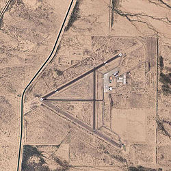
2006 USGS photo IATA: none – ICAO: none – FAA LID: P08 Summary Airport type Public Owner City of Coolidge Location Pinal County, Arizona Elevation AMSL 1,574 ft / 480 m Coordinates 32°56′09″N 111°25′36″W / 32.93583°N 111.42667°W Runways Direction Length Surface ft m 5/23 5,528 1,685 Asphalt 17/35 3,861 1,177 Asphalt Statistics (2005) Aircraft operations 6,490 Based aircraft 41 Source: Federal Aviation Administration[1] 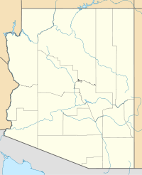
 Coolidge MAPLocation of Coolidge Municipal Airport, Arizona
Coolidge Municipal Airport (FAA LID: P08) is a city-owned, public-use airport located five miles (8 km) southeast of the central business district of Coolidge, a city in Pinal County, Arizona, United States.[1]
Contents
History
The airport was opened about 1943 as Coolidge Army Airfield and was used by the United States Army Air Forces during World War II. The original airfield was constructed with three runways in a triangular configuration. Of these three runways, two remain: Runway 17-35 and Runway 5-23. Numerous support facilities were constructed, of which a 120-foot (37 m) by 80-foot (24 m) hangar still remains. Originally constructed as an Air Transport Command base, Coolidge Army Airfield served as an auxiliary operating base for Williams Field during World War II, and conducted advanced two-engine flying training. Transferred fully to Air Transport Command on 15 May 1944, however AAF Training Command continued to use the field until 28 August 1946 when the facility was inactivated and put into standby status.
On January 19, 1950 the airfield was transferred to Pinal County since the airfield was no longer needed by the United States Air Force. Pinal County owned and operated the airport until 1959 when the City of Coolidge obtained ownership of the airport. On March 2, 1959 the airport was officially transferred from Pinal County ownership to the City of Coolidge.
From 1962 until July 1992, operations at the airport were dominated by training activities of Cessna T-37 jet training aircraft based at Williams Air Force Base. The Air Force had a lease agreement with the City of Coolidge for four parcels of land and joint use of the main runways and taxiways in return for the continued maintenance and upkeep of the main runway and taxiway. In addition, they constructed several facilities along the runway and apron to support their operations.
The Air Force lease was terminated in July 1992 and training operations at the airport ceased in June 1992.[2]
Facilities and aircraft
Coolidge Municipal Airport covers an area of 1,268 acres (513 ha) which contains two asphalt paved runways: 5/23 measuring 5,528 x 150 ft (1,685 x 46 m) and 17/35 measuring 3,861 x 75 ft (1,177 x 23 m).[1]
For the 12-month period ending July 31, 2005, the airport had 6,490 aircraft operations, an average of 17 per day: 99% general aviation and 1% military. At that time there were 41 aircraft based at this airport: 61% single-engine, 24% multi-engine, 7% jet, 5% helicopter and 2% glider.[1]
See also
References
 This article incorporates public domain material from websites or documents of the Air Force Historical Research Agency.
- Shaw, Frederick J. (2004), Locating Air Force Base Sites History’s Legacy, Air Force History and Museums Program, United States Air Force, Washington DC, 2004.
- Manning, Thomas A. (2005), History of Air Education and Training Command, 1942–2002. Office of History and Research, Headquarters, AETC, Randolph AFB, Texas ASIN: B000NYX3PC
- ^ a b c d FAA Airport Master Record for P08 (Form 5010 PDF), effective 2008-04-10
- ^ Thole, Lou (1999), Forgotten Fields of America : World War II Bases and Training, Then and Now - Vol. 2. Publisher: Pictorial Histories Pub, ISBN 1575100517
External links
- Coolidge Municipal Airport (P08) at Arizona DOT airport directory
- Resources for this airport:
- AirNav airport information for P08
- FlightAware airport information and live flight tracker
- SkyVector aeronautical chart for P08
 Army Air Forces Training Command
Flying Training Flying Schools Eastern Flying Training Command · Central Flying Training Command · Western Flying Training CommandSpecialized Schools Bombardier · Contract Flying · Glider Training · Gunnery · Navigator
Technical Training Eastern Technical Training Command · Central Technical Training Command · Western Technical Training CommandCategories:- 1941 establishments
- Airfields of the United States Army Air Forces in Arizona
- USAAF West Coast Training Center
- World War II Desert Airfields
- Airports in Pinal County, Arizona
- USAAF Air Transport Command Airfields - North America


Wikimedia Foundation. 2010.