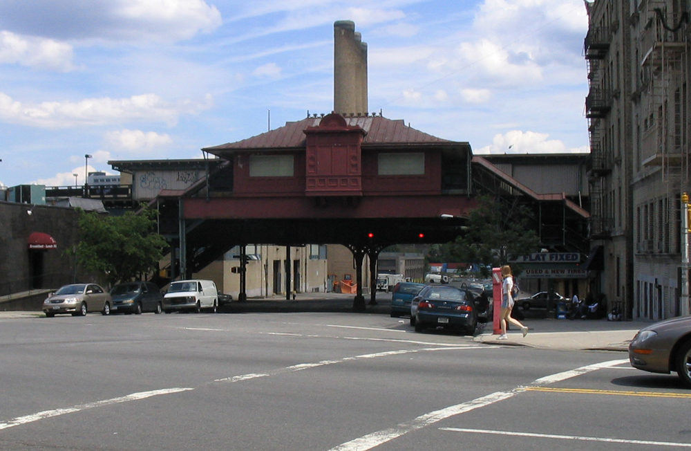
215th Street (IRT Broadway–Seventh Avenue Line)
- 215th Street (IRT Broadway–Seventh Avenue Line)
Infobox NYCS
name = 215th Street

bg_color = #E20F00
line = IRT Broadway–Seventh Avenue Line
service = Broadway-Seventh north local
platforms = 2 side platforms
tracks = 3
borough = Manhattan
open_date = March 12, 1906
north_station = Marble Hill–225th Street
north_line = IRT Broadway–Seventh Avenue Line
north_service = Broadway-Seventh north local
south_station = 207th Street
south_line = IRT Broadway–Seventh Avenue Line
south_service = Broadway-Seventh north local
215th Street is a local station on the IRT Broadway–Seventh Avenue Line of the New York City Subway. Located at the intersection of 215th Street and Tenth Avenue in the Manhattan neighborhood of Inwood, it is served by the NYCS|1 train at all times.
The station is near the northern end of the 207th Street Yard. It is also a short block from Inwood Hill Park and provides access to Columbia University's Baker Field athletic complex. North of the station, the tracks cross the Broadway Bridge over Spuyten Duyvil Creek, and onto the mainland. The express track that passes through the station is currently unused in revenue service.
The 1991 artwork here is called "Elevated Nature I-IV" by Wopo Holup. It is also located at four other stations on this line.
Bus connection
*M100
External links
*NYCS ref|http://www.nycsubway.org/perl/stations?6:148|IRT West Side Line|215th Street
*Station Reporter — [http://www.stationreporter.net/1train.htm 1 Train]
Wikimedia Foundation.
2010.
Look at other dictionaries:
207th Street (IRT Broadway–Seventh Avenue Line) — Infobox NYCS name = 207th Street bg color = #E20F00 line = IRT Broadway–Seventh Avenue Line service = Broadway Seventh north local platforms = 2 side platforms tracks = 3 borough = Manhattan open date = March 16, 1906 north station = 215th Street … Wikipedia
Marble Hill–225th Street (IRT Broadway–Seventh Avenue Line) — Infobox NYCS name = Marble Hill–225th Street bg color = #E20F00 line = IRT Broadway–Seventh Avenue Line service = Broadway Seventh north local platforms = 2 side platforms tracks = 3 borough = Manhattan connection = Metro North Railroad at Marble … Wikipedia
IRT Broadway–Seventh Avenue Line — Infobox rail line name = IRT Broadway–Seventh Avenue Line image width = 150 px caption = type = Rapid transit system = New York City Subway status = locale = start = Van Cortlandt Park–242nd Street end = South Ferry Borough Hall stations = 44… … Wikipedia
IRT Broadway–Seventh Avenue Line — Broadway–Seventh Avenue Line Метрополитен Нью Йорка Станция South Ferry ныне закрытая станция, расположенная на разворотном круге … Википедия
Broadway (New York City) — Broadway South end: Stone Street / Whitehall Street, Lower Manhattan, in New York City Major junctions … Wikipedia
Chambers Street (Manhattan) — For other uses, see Chambers Street (disambiguation). Eastern end towards the Manhattan Municipal Building Chambers Street is a bi directional (two way) street in the New York City borough of Manhattan. It runs from River Terrace, Battery Park… … Wikipedia
History of the IRT subway before 1918 — Main article: History of the New York City Subway The first regularly operated subway in New York City was built by the city and leased to the Interborough Rapid Transit Company for operation under Contracts 1 and 2. Until 1918, when the new H… … Wikipedia
National Register of Historic Places listings in Manhattan above 110th Street — Main article: National Register of Historic Places listings in New York County, New York List of the National Register of Historic Places listings in Manhattan above 110th Street Map of all coordinates from Google … Wikipedia
125th Street (Manhattan) — Coordinates: 40°48′39″N 73°57′09″W / 40.8108°N 73.9526°W / 40.8108; 73.9526 … Wikipedia
Dyckman Street — North end Dyckman Street is a street in the Inwood neighborhood of Manhattan, New York City. It is commonly considered to be a crosstown street because it runs from the Hudson River to the Harlem River and intersects Broadway. However, in its… … Wikipedia

