- Bass Lake (California)
-
Bass Lake 
Location Sierra National Forest
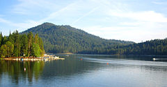
Madera County, CaliforniaCoordinates 37°17′27″N 119°31′30″W / 37.29077°N 119.52513°WCoordinates: 37°17′27″N 119°31′30″W / 37.29077°N 119.52513°W Lake type Reservoir Primary inflows Willow Creek Primary outflows Willow Creek Basin countries United States Max. length 6.7 km (4.2 mi) Max. width 0.64 km (0.40 mi) Surface area 472 ha (1,170 acres) Max. depth 30 m (98 ft) Water volume 56,100,000 m3 (45,500 acre·ft) Surface elevation 1,027 m (3,369 ft) Settlements Bass Lake, California References [1][2] Bass Lake is a freshwater artificial lake in the Sierra National Forest, of Madera County, California, approximately 14 mi (23 km) south of the entrance to Yosemite National Park. The lake is formed by the construction of the Crane Valley Dam across Willow Creek, a tributary to the San Joaquin River, and is referenced as Crane Valley Lake.[3] Releases from the dam drive the hydro-electric powerplant operated by Pacific Gas and Electric Company.[4]
Most of the land around the lake is part of the Sierra National Forest. The U.S. Forest Service designated the lake an official Recreation Area and has developed campgrounds and picnic areas on the south shore of the lake. The north shore of the lake is primarily made up of private cabins and homes of the unincorporated community, Bass Lake, California, with a year-round population of 2,195.[5]
Contents
Tourism
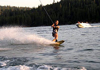
Much of the area surrounding Bass Lake is devoted to the tourism industry. With daytime temperatures regularly topping 100 °F (38 °C) in summer, the lake water typically reaches 80 °F (27 °C) during those months. Fishing, swimming, water skiing, and personal watercrafting are popular.[6]
Hells Angels
In 1963, Bass Lake became a yearly destination for the Hells Angels Motorcycle Club (HAMC), attracting hundreds of bikers from across the state. A first-hand report of the 1965 Bass Lake Run was reported by Hunter S. Thompson in his first book, Madera County and its surrounding areas in an effort to block, or at least control, the Hells Angels activity.
The run peaked in the 1970s before slowly fading away altogether by the late 1980s.
See also
References
- ^ "Bass Lake Dam". BassLakeCA.com. 2009. http://basslakeca.com/dam.html. Retrieved 2009-03-13.
- ^ U.S. Geological Survey (2009). "Feature Detail Report: Bass Lake". Geographic Names Information System (GNIS). U.S. Department of the Interior. http://geonames.usgs.gov/pls/gnispublic/f?p=116:3:339445792520671::NO::P3_FID,P3_TITLE:266417%2CBass%20Lake. Retrieved 2009-03-13.
- ^ Department of Water Resources Division of Safety of Dams (2009). "Listing of Dams". California Data Exchange Center. State of California. http://www.water.ca.gov/damsafety/damlisting/index.cfm. Retrieved 2009-04-01.
- ^ "Bass Lake History". BassLakeCA.com. 2009. http://basslakeca.com/history.html. Retrieved 2009-03-13.
- ^ "History, Then and Now...". Oakhurst Chamber of Commerce. 2009. http://www.oakhurstchamber.com/index.php?src=gendocs&ref=History&category=Main. Retrieved 2009-03-13.
- ^ "Bass Lake (Crane Valley)". Madera County, California GenWeb. 21 December 2008. http://www.cagenweb.com/madera/BassLake.html. Retrieved 2009-03-13.
External links
Categories:- Reservoirs in California
- Sierra National Forest
- Lakes of Madera County, California
- Hells Angels
- Sierra Nevada (U.S.)
- Buildings and structures in Madera County, California
Wikimedia Foundation. 2010.

