- Laurencekirk railway station
Infobox UK disused station
name = Laurencekirk
other_name =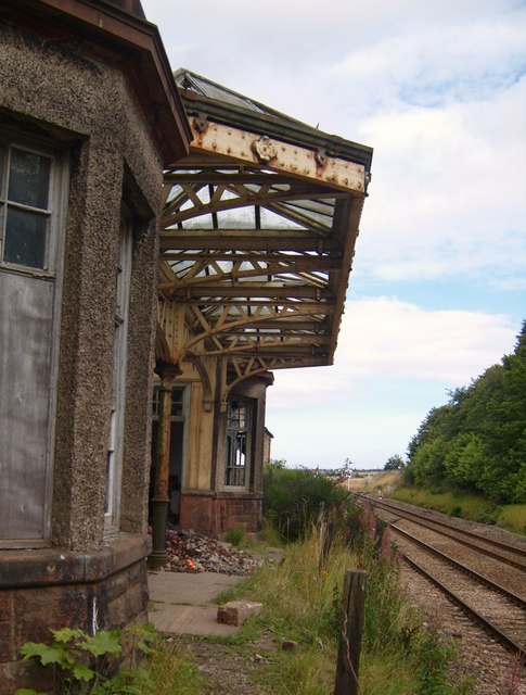
caption =
code =
locale =Laurencekirk
borough =Aberdeenshire
latitude =
longitude =
platforms = 2
original =Aberdeen Railway
pregroup =Caledonian Railway
postgroup = LMS
years = 1 November 1849
events = OpenedButt (1995), page 139]
years1 = 4 September 1967
events1 = Closed
years2 = Spring 2009
events2 = Proposed re-openingcite web | url = http://www.transportscotland.gov.uk/news/Minister-25-years-ScotRail-network-major-boost-east-coast-services | title = Minister celebrates 25 years of ScotRail network by announcing major boost to east coast services | accessdate = 2008-10-07 ]Laurencekirk railway station is a
mothballed railway station that is due to reopen. The reopened station will serve the communities ofLaurencekirk and The Mearns from December 2008.History
The station was built by the
Aberdeen Railway , which ran from Aberdeen in the north to Guthrie (just outsideArbroath ) to the south. The line joined theNorth British, Arbroath and Montrose Railway north of Montrose at Kinnaber Junction andArbroath and Forfar Railway at the triangular junctions at Friockheim and Guthrie.Awdry (1990)] [Jowett (1989)] RAILSCOT]Closure
The station was closed in September 1967 by
British Railways , at a time when they were looking to cut costs across their network, this despite the line on which the station stands being a busy main-line with frequent, direct services toLondon ,Edinburgh ,Glasgow and a number of major destinations in England.rail line
previous = Montrose
next = Stonehaven
route =First ScotRail Edinburgh to Aberdeen Line
col = ff80c0rail line
previous = Marykirk
"Line open; station closed
next = Fordoun
"Line open; station closed
route =Caledonian Railway Aberdeen Railway
col = Caledonian colour
###@@@KEYEND@@@###Proposal to reopen and refurbishment
The residents of Laurencekirk, many of whom now commute to
Aberdeen andDyce had successfully campaigned for the station to be re-opened - the official announcement being made during December 2006 that the station would open in December 2007. cite web|url=http://www.scottish.parliament.uk/business/committees/historic/petitions/or-03/pu03-0302a.htm |title=Rail Network (Local Railway Stations) (PE629) |accessdate=2008-04-06 |date=2003-09-03 |work=Public Petitions Committee |publisher=Scottish Parliament ] The announcement of December 2007 for the re-commencement of services to and from Laurencekirk was ultimately overly ambitious and it was announced in early 2008 that the station would be finished and ready for the December 2008 timetable change.cite news | first=Charles | last=Wallace | coauthors= | title=Station plans on course | date=2008-03-20 | publisher=Johnston Press | url =http://www.kincardineshireobserver.co.uk/news/Station-plans-on-course.3899855.jp | work =Kincardineshire Observor | pages = | accessdate = 2008-04-06 | language = ] However, in a New Release from Transport Scotland, the opening date was given at Spring 2009.The station building, which is presently is rather poor overall condition will be refurbished during Spring 2008, and a new
car park with 70 parking spaces will be built across the railway line from the station building, together with a small number of disabled parking spaces next to the station building.First ScotRail have announced they have made provisional plans for 19 trains to serve the station each day, made up of 10 northbound services and 9 southbound services, with southbound services serving both Edinburgh and Glasgow.Fact|date=October 2008 First ScotRail will also be responsible for gritting and snowclearing at the station.National Express East Coast services to/fromLondon andCrossCountry services to the south will not initially stop at Laurencekirk, but the platforms will be of sufficient length to permit these services to stop in future and to permit First ScotRail to operate longer trains in the future. A new football will also be installed at the station.Fact|date=October 2008 The total cost of these works will total aroundGBP 3.24 million.cite news | first= | last= | coauthors= | title=RAILWAY STATION PLANS BACK ON TRACK | date=2007-09-28 | publisher=Johnston Press | url =http://www.mearnsleader.co.uk/news/RAILWAY-STATION-PLANS-BACK-ON.3241998.jp | work =Mearns Leader | pages = | accessdate = 2008-04-06 | language = ] cite news | first= | last= | coauthors= | title=RAILWAY STATION PLANS BACK ON TRACK | date=2007-09-28 | publisher=Johnston Press | url =http://www.mearnsleader.co.uk/news/RAILWAY-STATION-PLANS-BACK-ON.3241998.jp | work =Mearns Leader | pages = | accessdate = 2008-04-06 | language = ]References
Notes
ources
*
*
*
*
Wikimedia Foundation. 2010.