- Montrose railway station
-
This article is about the railway station in Scotland. For the station in New York, see Montrose (Metro-North station).
Montrose 
Scottish Gaelic: Mon Rois 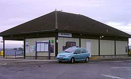
Montrose railway station Location Place Montrose Local authority Angus Coordinates 56°42′47″N 2°28′19″W / 56.713°N 2.472°WCoordinates: 56°42′47″N 2°28′19″W / 56.713°N 2.472°W Operations Station code MTS Managed by First ScotRail Number of platforms 2 Live arrivals/departures and station information
from National Rail EnquiriesAnnual rail passenger usage 2004/05 * 0.319 million 2005/06 *  0.346 million
2006/07 * 0.348 million2007/08 * 0.369 million2008/09 *  0.366 million
2009/10 * 0.356 millionNational Rail - UK railway stations A B C D E F G H I J K L M N O P Q R S T U V W X Y Z * Annual passenger usage based on sales of tickets in stated financial year(s) which end or originate at Montrose from Office of Rail Regulation statistics. Please note: methodology may vary year on year. Montrose railway station serves the town of Montrose in Angus, Scotland. The station overlooks the Montrose Basin.
Preceding station  National Rail
Following station Arbroath CrossCountry
Cross Country NetworkStonehaven Arbroath First ScotRail
Glasgow to Aberdeen Line
Edinburgh to Aberdeen LineLaurencekirk Arbroath First ScotRail
Highland Caledonian SleeperStonehaven Arbroath East Coast
East Coast Main LineStonehaven Historical railways Lunan Bay
Line open; Station closedNorth British, Arbroath and Montrose Railway Hillside
Line open; Station closedReferences
Notes
Sources
- Butt, R. V. J. (1995). The Directory of Railway Stations: details every public and private passenger station, halt, platform and stopping place, past and present (1st ed.). Sparkford: Patrick Stephens Ltd. ISBN 1-8526-0508-1. OCLC 60251199.
- Jowett, Alan (March 1989). Jowett's Railway Atlas of Great Britain and Ireland: From Pre-Grouping to the Present Day (1st ed.). Sparkford: Patrick Stephens Ltd. ISBN 1-8526-0086-1. OCLC 22311137.
Categories:- Railway stations in Angus
- Former North British Railway stations
- Railway stations opened in 1883
- Railway stations served by CrossCountry
- Railway stations served by First ScotRail
- Railway stations served by East Coast
- Scotland railway station stubs

Wikimedia Foundation. 2010.