- Marblemount, Washington
-
Marblemount, Washington — CDP — Location of Marblemount, Washington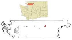
Coordinates: 48°32′17″N 121°26′16″W / 48.53806°N 121.43778°WCoordinates: 48°32′17″N 121°26′16″W / 48.53806°N 121.43778°W Country United States State Washington County Skagit Area – Total 2.5 sq mi (6.4 km2) – Land 2.4 sq mi (6.1 km2) – Water 0.1 sq mi (0.3 km2) Elevation 315 ft (96 m) Population (2010) – Total 203 – Density 106.1/sq mi (41.0/km2) Time zone Pacific (PST) (UTC-8) – Summer (DST) PDT (UTC-7) ZIP code 98267 Area code 360 FIPS code 53-43325[1] GNIS feature ID 1522717[2] Marblemount is a census-designated place (CDP) in Skagit County, Washington, United States. The population was 203 at the 2010 census. It is included in the Mount Vernon–Anacortes, Washington Metropolitan Statistical Area. Original location for the Summer Rock the Art Fest (formerly known as Beaver Fest)
Geography
Marblemount is located at 48°32′17″N 121°26′16″W / 48.53806°N 121.43778°W (48.538154, -121.437844).[3]
According to the United States Census Bureau, the CDP has a total area of 2.5 square miles (6.4 km²), of which, 2.4 square miles (6.1 km²) of it is land and 0.1 square miles (0.3 km²) of it (4.44%) is water.
Demographics
As of the census[1] of 2000, there were 251 people, 93 households, and 59 families residing in the CDP. The population density was 106.1 people per square mile (40.9/km²). There were 124 housing units at an average density of 52.4/sq mi (20.2/km²). The racial makeup of the CDP was 94.02% White, 0.40% African American, 1.99% Native American, 0.80% from other races, and 2.79% from two or more races. Hispanic or Latino of any race were 0.80% of the population.
There were 93 households out of which 32.3% had children under the age of 18 living with them, 46.2% were married couples living together, 11.8% had a female householder with no husband present, and 35.5% were non-families. 31.2% of all households were made up of individuals and 7.5% had someone living alone who was 65 years of age or older. The average household size was 2.70 and the average family size was 3.28.
In the CDP the age distribution of the population shows 31.1% under the age of 18, 5.6% from 18 to 24, 25.5% from 25 to 44, 27.9% from 45 to 64, and 10.0% who were 65 years of age or older. The median age was 37 years. For every 100 females there were 116.4 males. For every 100 females age 18 and over, there were 124.7 males.
The median income for a household in the CDP was $25,156, and the median income for a family was $26,250. Males had a median income of $37,232 versus $15,278 for females. The per capita income for the CDP was $15,353. About 14.3% of families and 16.5% of the population were below the poverty line, including 10.8% of those under the age of eighteen and 26.7% of those sixty five or over.
References
- ^ a b "American FactFinder". United States Census Bureau. http://factfinder.census.gov. Retrieved 2008-01-31.
- ^ "US Board on Geographic Names". United States Geological Survey. 2007-10-25. http://geonames.usgs.gov. Retrieved 2008-01-31.
- ^ "US Gazetteer files: 2010, 2000, and 1990". United States Census Bureau. 2011-02-12. http://www.census.gov/geo/www/gazetteer/gazette.html. Retrieved 2011-04-23.
Municipalities and communities of Skagit County, Washington Cities 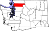
Towns CDPs Alger | Bay View | Big Lake | Clear Lake | Conway | Edison | Lake Cavanaugh | Lake McMurray | Marblemount | Rockport
Unincorporated
communitiesAvon | Bow | Samish Island
Indian reservations Categories:- Populated places in Skagit County, Washington
- Census-designated places in Washington (state)


Wikimedia Foundation. 2010.