- Colony Township, Greeley County, Kansas
-
Colony Township — Township — Location in Greeley County
Coordinates: 38°31′25″N 101°56′17″W / 38.52361°N 101.93806°WCoordinates: 38°31′25″N 101°56′17″W / 38.52361°N 101.93806°W Country United States State Kansas County Greeley Area - Total 354.77 sq mi (918.86 km2) - Land 354.77 sq mi (918.86 km2) - Water 0 sq mi (0 km2) 0% Elevation 3,812 ft (1,162 m) Population (2000) - Total 172 - Density 0.5/sq mi (0.2/km2) GNIS feature ID 0485231 Colony Township is a township in Greeley County, Kansas, USA. As of the 2000 census, its population was 172.
Contents
Geography
Colony Township covers an area of 354.77 square miles (918.9 km2) and contains no incorporated settlements. According to the USGS, it contains two cemeteries: Mathews and Rogers.
The stream of South Fork White Woman Creek runs through this township.
Transportation
Colony Township contains two airports or landing strips: Tuttle Landing Field and Walter Airport.
References
External links
Municipalities and communities of Greeley County, Kansas County seat: Tribune Cities 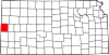
Townships Categories:- Townships in Greeley County, Kansas
- Kansas geography stubs


Wikimedia Foundation. 2010.