- San Benito, Texas
Infobox Settlement
official_name = San Benito, Texas
settlement_type =City
nickname = The Resaca City, San Bene
motto =
imagesize =
image_caption =
image_
mapsize = 250x200px
map_caption = Location of San Benito, Texas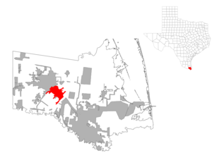
mapsize1 = 250px
map_caption1 =subdivision_type = Country
subdivision_name =United States
subdivision_type1 = State
subdivision_name1 =Texas
subdivision_type2 = County
subdivision_name2 = Camerongovernment_footnotes =
government_type =
leader_title =
leader_name =
leader_title1 =
leader_name1 =
established_title =
established_date =unit_pref = Imperial
area_footnotes =area_magnitude =
area_total_km2 = 29.0
area_land_km2 = 28.5
area_water_km2 = 0.5
area_total_sq_mi = 11.2
area_land_sq_mi = 11.0
area_water_sq_mi = 0.2population_as_of = 2000
population_footnotes =
population_total = 23444
population_density_km2 = 822.5
population_density_sq_mi = 2130.2timezone = Central (CST)
utc_offset = -6
timezone_DST = CDT
utc_offset_DST = -5
elevation_footnotes =
elevation_m = 11
elevation_ft = 36
latd = 26 |latm = 8 |lats = 12 |latNS = N
longd = 97 |longm = 38 |longs = 9 |longEW = Wpostal_code_type =
ZIP code
postal_code = 78586
area_code = 956
blank_name = FIPS code
blank_info = 48-65036GR|2
blank1_name = GNIS feature ID
blank1_info = 1375956GR|3
website =
footnotes =San Benito is a city in Cameron County,
Texas , U.S., The population was 25,005 at the 2006 census. It is the birthplace of Country and Tex-Mex music iconFreddy Fender . San Benito celebrated the 100th anniversary of the naming of the city April 3, 2007. The post office was named Diaz from April to May 1907. The San Benito Museum, Freddy Fender Museum and Conjunto Music Museum opened in the same building Nov. 17, 2007.San Benito is part of the Brownsville–Harlingen Metropolitan Statistical Area.
Geography
San Benito is located at coor dms|26|8|12|N|97|38|9|W|city (26.136603, -97.635878)GR|1.
According to the
United States Census Bureau , the city has a total area of 11.2square mile s (29.0km² ), of which, 11.0 square miles (28.5 km²) of it is land and 0.2 square miles (0.5 km²) of it (1.87%) is water.It should be noted that San Benito is also known as "The Resaca City", due to its resaca (a former tributary of the Rio Grande, which has been cut off for irrigation purposes).San Benito was first a village named Diaz, after
Porfirio Díaz , president of Mexico. Following the arrival of the railroad in 1904 and irrigation in 1906, Anglo settlers began moving to San Benito and the rest of the Rio Grande Valley. The Diaz post office (Sam Robertson, Postmaster) operated April 2, 1907 until May 11, 1907 when it became San Benito. A September 1898 postcard from Diaz with only a Houston train postmark exists prompting speculation that Diaz existed as a village ten + years prior to Diaz/San Benito founding in 1907. Another Diaz Post Office inHardeman County, Texas (SE corner TX panhandle @ Oklahoma border) was proposed 25 Oct 1904 but never opened. The order was rescinded 31 Dec 1904.Demographics
As of the
census GR|2 of 2006, there were 25,005 people, 7,065 households, and 5,715 families residing in the city. Thepopulation density was 2,130.2 people per square mile (822.1/km²). There were 9,120 housing units at an average density of 828.7/sq mi (319.8/km²). The racial makeup of the city was 76. 2% White, 0.3% African American, 0.4% Native American, 0.2% Asian, 20.5% from other races, and 2.4% from two or more races. Hispanic or Latino of any race were 86.9% of the population. San Benito has been a model of integration of Hispanic and Anglo cultures, similar to the way Galveston TX has done the same with African American and Anglo cultures.There were 7,065 households out of which 41.4% had children under the age of 18 living with them, 56.6% were married couples living together, 19.5% had a female householder with no husband present, and 19.1% were non-families. 16.8% of all households were made up of individuals and 10.7% had someone living alone who was 65 years of age or older. The average household size was 3.30 and the average family size was 3.72.
In the city the population was spread out with 33.3% under the age of 18, 10.5% from 18 to 24, 24.8% from 25 to 44, 17.8% from 45 to 64, and 13.6% who were 65 years of age or older. The median age was 30 years. For every 100 females there were 90.2 males. For every 100 females age 18 and over, there were 84.1 males.
The median income for a household in the city was $24,027, and the median income for a family was $26,415. Males had a median income of $22,097 versus $18,512 for females. The
per capita income for the city was $10,317. About 28.7% of families and 32.7% of the population were below thepoverty line , including 42.1% of those under age 18 and 22.8% of those age 65 or over.History
San Benito, Texas, is known as the "Resaca City." A resaca, four hundred feet wide, flows through the city. As indicated by its Spanish name, the resaca was a dry river bed. It is now the main canal of a large irrigation system.
San Benito was at first named "Diaz" in honor of Porfirio Diaz, president of México at that time. The people in the San Benito area were predominantly of Mexican ancestry. The Anglo settlers came after the completion of the first irrigation system in 1906. Prior to that time, this region was an arid, mesquite-cactus-brush covered wilderness. Irrigation water touched off the crop production magic in the railroad.
On July 4, 1904, the first passenger train arrived at Diaz. To celebrate the coming of the new railroad, the community leaders renamed the railroad station "Bessie," in honor of Bessie Yoakum. Her father, B.F. Yoakum, was instrumental in the construction of the railroad.
Some time later, when the townsite was surveyed, the name was changed to "San Benito" in honor of Benjamin Hicks. He was a pioneer ranchman whose charitable attitude endeared him to the population. The name was suggested by Rafael Moreno, the popular 90 year old camp cook of the surveying party. Moreno suggested the name "San Benito" for his beloved "Saint Benjamin" Hicks.
San Benito was a village with a moderate number of homes, businesses, churches, and public schools several years before they were incorporated in 1911. The original map of the townsite was recorded April 28, 1907. The first school was established in 1907 with 48 pupils and Miss Kate Purvis as the teacher. The Post Office was also opened in 1907. In 1927 the city adopted a Commission form of government operating under a Home Rule Charter.
In 1920, when the city was included in the U.S. Census count for the first time, San Benito had become a city of 4,070 people. By 1950 the census count was 13,271. In 1960 the population had grown to 16,422. The present population is estimated at 26,350.
The irrigation district was organized in 1906. As a result of the availability of irrigation water, San Benito and all of the Lower Rio Grande Valley cities came to serve a newly developing agricultural territory.
The original townsite, created in 1911, contained 1,280 acres. Since then a series of annexations have increased the incorporated area to 4,092.17 acres.
The mild winter climate in southmost section of the United States has played a dominant role in the growth of San Benito and the other cities of the Lower Rio Grande Valley. Crops grow and flowers bloom year-round. The city has become a hotspot for winter tourists and retired people, providing a substantial percentage of the buying power of this community.
Barrios
San Benito is cultivated with Latino barrios that are profound in
Chicano culture.
* El Jardin
* La Calle Stenger
* La Gallina
* La Palma
* El Ranchito
* La PalomaFamous citizens
A list of San Benito's most notable people includes:
* Lt. Wilma Roland (Dolly) Vinsant Shea,World War II flight nurse [ [http://www.tsha.utexas.edu/handbook/online/articles/SS/hes1.html TSHA Online - Texas State Historical Association ] ] [ [http://www.commemorativeairforce.org/news/news_details.php?newsid=95 Official Home Page of the Commemorative Air Force ] ]
*General Tom Marchbanks ,United States Air Force [ [http://www.af.mil/bios/bio.asp?bioID=6297 Biographies : Major General Tom E. Marchbanks Jr ] ]
*King Cruse , aviation pioneer [ [http://www.texasescapes.com/Aviation/Patrolling-the-Mexican-Border-by-Air-1950s-Cruse-Aviation.htm Patrolling the Mexican Border by Air, Government and Private Enterprise Working Together ] ]
*Bobby Joe Morrow ,1956 Olympics 100 meter dash gold medalist
* Baldemar Huerta (Freddy Fender ), musician
*Charles Pugsley Fincher , cartoonist [ [http://www.theallisonlawfirm.com/HTMLpages/Charles.html Charles Pugsley Fincher ] ]
*T. R. Fehrenbach , author [ [http://www.randomhouse.com/author/results.pperl?authorid=8483 T.R. Fehrenbach - Authors - Random House ] ]
*Narciso Martinez , Conjunto musician [ [http://www.lib.utexas.edu/benson/border/arhoolie2/narciso.html Narciso Martínez "Father of the Texas-Mexican Conjunto" ] ]
*Alba Stimson Heywood , Founder of city [ [http://www.cameroncountyhistoricalcommission.org/ValleyHistory.htm#Colonel%20Heywood%20San%20Benito Valley History by Norman Rozeff ] ]
*Samuel A. Robertson , Founder of city [ [http://www.lone-star.net/mall/txtrails/SanBenito.htm San Benito, Texas ] ]
* Steven Ray Hernandez (C.H.A.R.M.), rapperEducation
The
San Benito Consolidated Independent School District serves San Benito.In addition,
South Texas Independent School District serves San Benito and many nearby communities by providing several magnet schools.South Texas Academy of Medical Technology (Med Tech) is located in San Benito.Television
The San Benito area is served by numerous local television affiliates.
*KVEO-TV (NBC 23) - Brownsville
*KGBT-TV (CBS 4) - Harlingen
*KRGV-TV (ABC 5) - Weslaco
* KNVO (Univision 48) - McAllen
*XHRIO-TV (FOX 2) -Matamoros, Tamaulipas
*KTLM (Telemundo 40) - McAllen
*KMBH-TV (PBS 60) - Harlingen
*KVTF-CA (Telefutura 20) - Brownsville
*KLUJ-TV (TBN 44) - Harlingen
*KBDF-LP (Azteca America 64) - BrownsvilleRadio Stations
*
KBFM Wild 104 (Hip Hop/Top 40) - [http://www.wild104.net/main.html Official Site]
*KFRQ Q94.5 The Rock Station (Classic/Modern/Hard Rock) - [http://www.q945rocks.com Official Site]
*KKPS Que Pasa 99.5 (Tejano) - [http://www.995quepasa.com Official Site]
*KNVO-FM Super Estrella (Super Star) 101.1 - [http://www.superstar101.com Official Site]
* KVLY Mix 107.9 KVLY (Adult Contemporary) - [http://www.mix1079.net Official Site]External links
References

Wikimedia Foundation. 2010.