- Everett Street Depot
-
Everett Street Depot 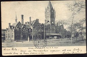
Everett Street Depot on an old postcardStation statistics Address West Everett Street
between N. 2nd and N. 4th Streets
Milwaukee, WisconsinOther information Opened 1886 Closed 1965 Everett Street Station, also called Milwaukee Union Station, was a railway station located in downtown Milwaukee, Wisconsin, built by the Chicago, Milwaukee, St. Paul and Pacific Railroad (CMStP&P RR), commonly known as "the Milwaukee Road." The station was located on West Everett Street between North 2nd Street and North 4th Street, and it featured a 140-foot-high clock tower—the largest in America at the time of construction. Designed by E. Townsend Mix in a "modern," functional style, the station combined the Gothic Revival style with elements drawing on Queen Anne and Romanesque Revival styles (such as stone archways) in an eclectic blend. Walter G. Berg gave a detailed description of the building in Buildings and Structures of American Railroads (1893).[1]
The station faced the Fourth Ward Park (since renamed Zeidler Park), which afforded both a vantage point for viewing the station and a bucolic respite from the mechanized industrial culture of the railroad. The station served passengers from its opening in 1886 until it was replaced by the Milwaukee Intermodal Station on August 4, 1965. The station was damaged by fire a week after closing and razed the following year.[2]
Services
The Everett Street Station served as the home station of the Milwaukee Road, also serving the Wisconsin Central and Milwaukee Northern Railroads. The station was also home to the Milwaukee Road's Hiawatha passenger trains.[2]
Clock Tower
After the clock tower had been lowered in the 1950s, the clock from the removed upper portion was installed to just above the roofline. Before demolition, one of the clock faces was removed and put into storage. It is now part of the Betty Brinn Children's Museum building, located at 929 E. Wisconsin Avenue in Milwaukee, which is very close to the site of the Chicago and North Western's razed Lakefront Depot.
References
- ^ Berg, Walter Gilman (1893). Buildings and Structures of American Railroads. A Reference Book for Railroad Managers, Superintendents, Master Mechanics, Engineers, Architects, and Students. J. Wiley. pp. 371. http://books.google.com/books?id=gIs5AAAAMAAJ&output=text.
- ^ a b Rutherford, Scott; Kevin J. Holland (2001). Classic American Railroad Terminals. MBI Publishing. pp. 58. ISBN 9780760308325. http://books.google.com/books?id=WI2XXKt_zncC&pg=PA58&lpg=PA58&dq=%22Everett+Street+Depot%22.
Categories:- Buildings and structures in Milwaukee, Wisconsin
- Demolished railway stations in the United States
- Stations along Milwaukee Road lines
- Railway stations opened in 1886
- Railway stations closed in 1965
- Railway stations in Wisconsin

Wikimedia Foundation. 2010.