- Chong-Alay District
-
Chong-Alay — Raion — 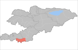
Country Kyrgyzstan Province Osh Province Area - Total 1,875.3 sq mi (4,857 km2) Population (2009)[1] - Total 23,598 - Urban density 13.5/sq mi (5.2/km2) enumerated de facto population Time zone GMT +5 (UTC+5) Chong-Alay District (big Alay) (Kyrgyz: Чоң Алай району; Russian: Чон-Алайский район) is a raion (district) of Osh Province in far south-western Kyrgyzstan. The capital lies at Daroot-Korgon.[2] The Chong-Alay District include 3 rural communities (ayıl ökmötü): Chong-Alay, Kashka-Suu, and Jekendi.[3]
Contents
Geography
Chong-Alay District occupies the western part of Alay Valley. The northern boundary of the district is located at Alay Mountains, and southern - at Trans-Alay Range. The valley is inclined from east to west, with the lowest point at 1560 meters above sea level.[4]
Climate is sharply continental with cold winters. Annual precipitation is 500–650 mm. Average temperature in July is +19-22C, and December -10-15C.[5]
The hydrology is dominated by Kyzyl-Suu (west) and its tributaries.
Demographics
As of 2009, Chong-Alay District comprised 1 town, and 99 villages. Its population, according to the Population and Housing Census of 2009, was 23,598. All people live in rural areas.
Historical populations in Chong-Alay District Year Pop. ±% 1970 7,892 — 1979 10,018 +26.9% 1989 14,689 +46.6% 1999 21,655 +47.4% 2009 23,598 +9.0% Note: enumerated de facto population; Source: [1] Ethnic composition
According to the 2009 Census, the ethnic composition of the Chong-Alay Distruct (de jure population) was:[1]
Ethnic group Population Proportion of Chong-Alay District population Kyrgyzs 25,039 99.9% other groups 11 0.1% Towns and villages
- Daroot-Korgon
- Kyzyl-Tuu
- Kyzyl-Eshme
- Chak
- Jashtilek
- Jarbashi
- Kulchu
- Sary-Bulak
- Karashibak
- Kashka-Suu
- Achysuu
- Kabyk
- Jayilma
- Karakabak
- Burgansuu
- Karamyk
- Jekendi
- Karateyit
- Shibe
- Chuluk
References
- ^ a b c Population and Housing Census 2009. Book 3 (in tables). Provinces of Kyrgyzstan: Chuy Province (Перепись населения и жилищного фонда Кыргызской Республики 2009. Книга 3 (в таблицах). Регионы Кыргызстана: Ошская область, Bishkek: National Committee on Statistics, 2010, http://212.42.101.100:8088/nacstat/sites/default/files/%D0%9E%D1%88%D1%81%D0%BA%D0%B0%D1%8F%20%D0%BE%D0%B1%D0%BB%D0%B0%D1%81%D1%82%D1%8C.pdf
- ^ "Administrative sub-division of Kyrgyzstan (map)". Enrin.grida.no. http://enrin.grida.no/htmls/kyrghiz/soe2/english/map/map3.htm. Retrieved 2010-03-14.
- ^ "List of rural communities of Kyrgyzstan". http://www.citykr.kg/en/ailnie_okruga.php. Retrieved 2010-03-14.
- ^ (in Russian) Ошская область:Энциклопедия [Encyclopedia of Osh Oblast]. Bishkek: Chief Editorial Board of Kyrgyz Soviet Encyclopedia. 1987. pp. 446.
- ^ "State Administration of Osh Oblast (in Russian)". http://www.osh.gov.kg/rayons/chonalai.htm. Retrieved 2010-03-14.
 Districts (Raions) of Kyrgyzstan
Capital: Bishkek (also four raions: Lenin, Oktyabr, Pervomay, Sverdlovsk) Batken Province 
Chuy Province Issyk Kul Province Jalal-Abad Province Naryn Province Osh Province Talas Province Categories:- Districts of Osh Province
- Osh geography stubs

Wikimedia Foundation. 2010.