- Nookat District
-
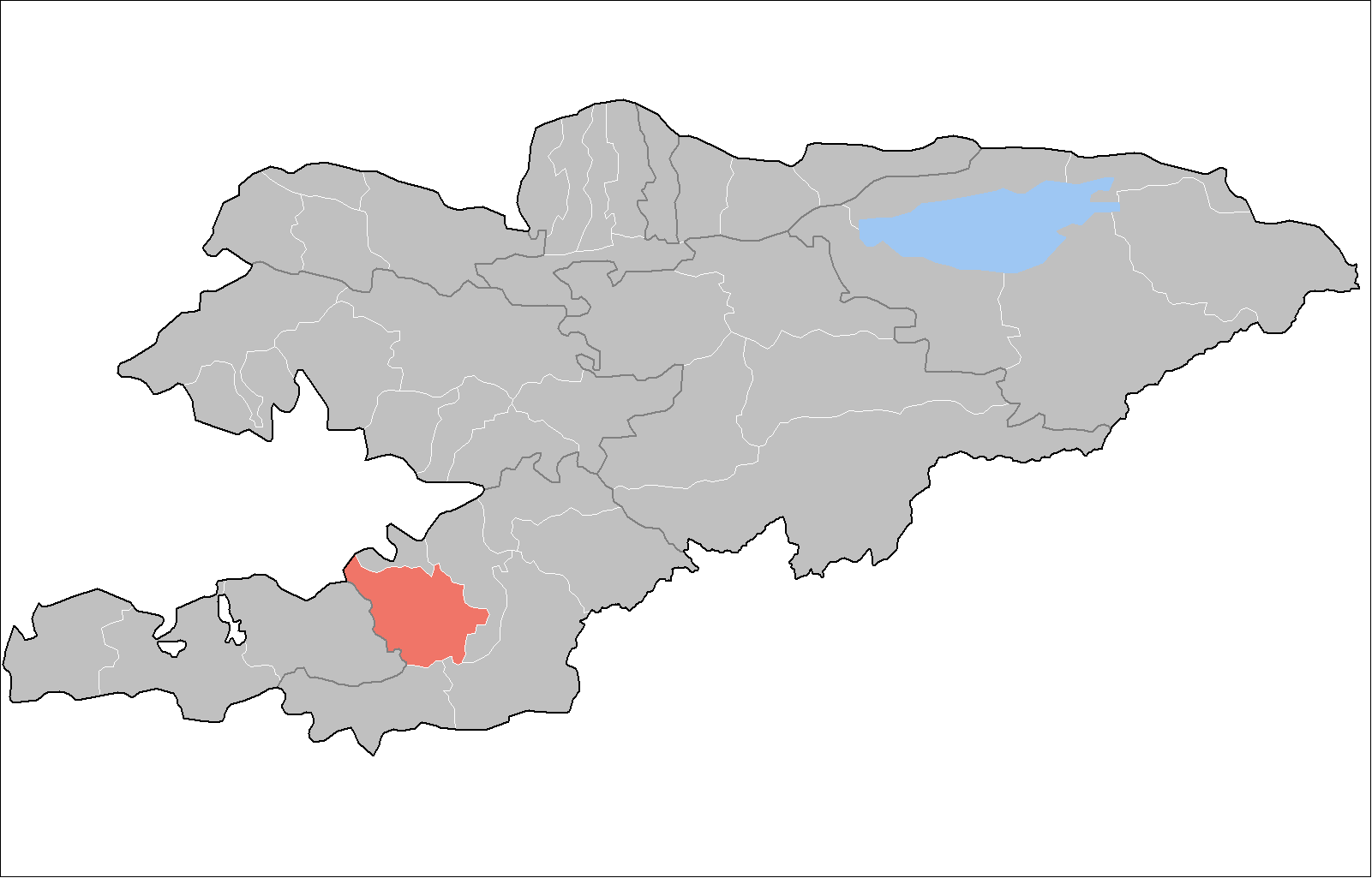
Nookat — Raion — 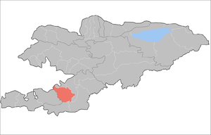
Country Kyrgyzstan Province Osh Province Population (2009)[1] – Total 236,455 Time zone GMT +5 (UTC+5) Nookat (also: Naukat) is a raion (district) of Osh Province in south-western Kyrgyzstan. The capital lies at Nookat.[2]:
Contents
Demographics
As of 2009, Nookat District included 1 town, 1 urban-type settlements, and 74 villages. Its population, according to the Population and Housing Census of 2009, was 214,995. Some 15,229 people live in urban areas, and 199,766 in rural ones.
Historical populations in Nookat District Year Pop. ±% 1970 76,970 — 1979 108,261 +40.7% 1989 144,225 +33.2% 1999 196,544 +36.3% 2009 214,995 +9.4% Note: enumerated de facto population; Source: [1] Ethnic composition
According to the 2009 Census, the ethnic composition of the Nookat Distruct (de jure population) was:[1]
Ethnic group Population Proportion of Kemin District population Kyrgyzs 173,920 73.6% Uzbeks 61,299 25.9% Khemshils 276 0.1% Turks 267 0.1% Russians 241 0.1% Tatars 123 0.1% other groups 329 0.1% Towns, rural communities, and villages
In total, Nookat District include 1 town, 1 urban-type settlement and 15 rural communities (aiyl okmotus). Each rural community can consist of one or several villages. The rural communities and settlements in the Nookat District are[3]:
- town Nookat
- urban-type settlement Nayman
- Bel' aiyl okmotu (center - village Bel', and also village Borbash)
- Gulstan aiyl okmotu (center - village Imeni Frunze, and also village Gulstan)
- Isanov aiyl okmotu (center - village Jany-Bazar, and also villages Jar-Korgon, Fedorovo, Chech-Debe, Kojoke, and Kichi-Alay)
- Karatash aiyl okmotu (center - village Karatash, and also village Noygut)
- Kulatov aiyl okmotu (center - village Kojo-Aryk and also villages Akchal, Baglan, Kosh Debe and Kyzyk Bulak)
- Jany Nookat aiyl okmotu (center - village Jany Nookat, and also villages Kyzyl Teyit, and Temir Koruk)
- Kenesh aiyl okmotu (center - village Kuu Maydan, and also villages Ak-Terek, Arbyn, Chegeden, and Shankol)
- Kyrgyz-Ata aiyl okmotu (center - village Keterme, and also villages Borko, Kara-Oy, Kara-Tash, Kyrgyz-Ata, Tash-Bulak, and Ak-Bulak)
- Imeni Toktomata Zulpueva aiyl okmotu (center - village Uchbay, and also villages Aybek, Ak-Chabuu, International, Karake, Kommunizm, Osor, Tashtak, Chuchuk, and Yatan)
- Kok-Bel aiyl okmotu (center - village Kok-Bel and also village Kaiyndy)
- Kyzyl Oktyabr aiyl okmotu (center - village Kek-Jar, and also villages Alashan, Borbash, Jiyde, Karanay, and Sarykandy)
- On Eki Bel aiyl okmotu (center - village On Eki Bel, and also village Naray)
- Teeles aiyl okmotu (center - village Murkut and also villages Ay-Tamga, Gerey-Shoron, Jaiylma, Dodon, Kenesh, Merkit, and Tolman)
- Mirmakhmud aiyl okmotu (center - village Imeni Chapaeva, and also villages Aral, Baryn, Budaylyk, Kapchygay, and Kara-Koktu)
- Yntymak aiyl okmotu (center - village Yntymak, and also villages Besh-Burkan, Aryk Boyu, Don Maala, Akshar, Tash-Bulak, Chelekchi, and Nichke-Suu)
References
- ^ a b c Population and Housing Census 2009. Book 3 (in tables). Provinces of Kyrgyzstan: Osh Province (Перепись населения и жилищного фонда Кыргызской Республики 2009. Книга 3 (в таблицах). Регионы Кыргызстана: Ошская область, Bishkek: National Committee on Statistics, 2010, http://212.42.101.100:8088/nacstat/sites/default/files/%D0%9E%D1%88%D1%81%D0%BA%D0%B0%D1%8F%20%D0%BE%D0%B1%D0%BB%D0%B0%D1%81%D1%82%D1%8C.pdf
- ^ Enrin.grida.no
- ^ [1]
 Districts (Raions) of KyrgyzstanCapital: Bishkek (also four raions: Lenin, Oktyabr, Pervomay, Sverdlovsk)
Batken Province 
Chuy Province Issyk Kul Province Jalal-Abad Province Naryn Province Osh Province Talas Province Categories:- Districts of Osh Province
- Osh geography stubs
Wikimedia Foundation. 2010.