- Nottaway River
-
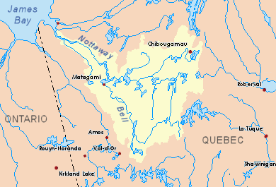
Nottaway River Country Canada Province Quebec Region Jamésie Source Lake Matagami - location Matagami - coordinates 50°03′00″N 77°28′10″W / 50.05°N 77.46944°W Mouth Rupert Bay off James Bay - location About 17 km SW of Waskaganish - elevation 0 m (0 ft) - coordinates 51°23′30″N 78°48′00″W / 51.39167°N 78.8°W Length 225 km (140 mi) Basin 65,800 km2 (25,400 sq mi) [1] Discharge - average 1,190 m3/s (42,020 cu ft/s) [1] 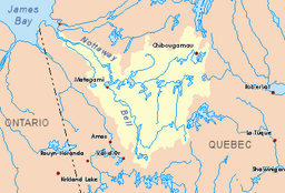 Nottaway River basin in yellow
The Nottaway River is a river in Quebec, Canada. The river drains Lake Matagami and travels 225 kilometers (140 mi) north-west before emptying into Rupert Bay at the south end of James Bay. Its drainage basin is 65,800 square kilometers (25,400 sq mi) and has a mean discharge of 1190 m³/s (1556 yd³/s). Its source is the head of the Mégiscane River, which is 776 kilometers (482 mi) from the mouth.[1]
Significant lakes along its course are Soscumica Lake (50°15′N 77°27′W / 50.25°N 77.45°W) and Dusaux Lake (50°45′00″N 77°53′30″W / 50.75°N 77.89167°W).
The Nottaway, together with the Broadback and Rupert Rivers, was initially considered to be dammed and developed as part of the James Bay Project. But in 1972 hydro-electric development began on the more northerly La Grande and Eastmain Rivers, and the NBR Project was shelved. With the decision to divert the Rupert River to the La Grande, it is not likely that the Nottaway will be developed in the foreseeable future.
Contents
Toponymy
In the seventeenth century, the Iroquois invaded the Algonquin territory near James Bay along this river. So when European cartographers started to map the river in the late seventeenth century, they called it "Rivière des Iroquois" (Iroquois River), as shown on maps of Jean-Baptiste-Louis Franquelin in 1699, Guillaume Delisle in 1703, and Jacques-Nicolas Bellin in 1744.[2]
Yet various forms of "Nottaway" started to appear in the early 18th century. "Noddaways" in 1715, "Nodaway" in 1743, "Nodaoay" and "Nodway" in 1744. Geologists James Richardson and Albert Peter Low used "Notaway River" in their reports (of 1880 and 1885 respectively). The current spelling "Nottaway" was established in the early twentieth century. It is beliefed to come from the Algonquin word nadowe, meaning "snake" and which the Algonquin tribes used to identify or describe their enemies, including the Iroquois. The Cree called this river Natuweu Nipi, and the Iroquois name was Nottaweou.[2]
Tributaries
Major tributaries of the Nottaway River include:
- Kitchigama River
- Lake Matagami
- Allard River
- Bell River
- Rivière Laflamme
- Rivière Mégiscane
- Waswanipi River
- Chibougamau River
- Opawica River
See also
- List of longest rivers of Canada
References
- ^ a b c Atlas of Canada
- ^ a b "Rivière Nottaway" (in French). Commission de toponymie du Québec. http://www.toponymie.gouv.qc.ca/ct/topos/carto.asp?Speci=44898&Latitude=51,37611&Longitude=-78,92944&Zoom=1700. Retrieved 2008-11-18.
Categories:- Rivers of Quebec
- Tributaries of James Bay
Wikimedia Foundation. 2010.