- Lackawaxen Township, Pennsylvania
Geobox Township
name = Lackawaxen Township
native_name =
other_name =
other_name1 =
category = Township
image_size =
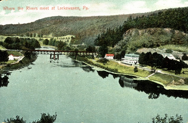
image_caption = Lackawaxen, showing the Erie Railroad iron truss bridge crossing theLackawaxen River at the confluence of theDelaware River in the foreground, at Minisink Ford,New York
flag_size =
symbol =
symbol_size =
nickname =
motto =
country = United States
state = Pennsylvania
region = Pike
region_type = County
district =
area_imperial = 81.1
area_land_imperial = 78.6
area_water_imperial = 2.5
area_water_percentage = auto
area_percentage_round = 2
area_round = 1
location =
lat_d = 41
lat_m = 29
lat_s = 15
lat_NS = N
long_d = 75
long_m = 02
long_s = 43
long_EW = W
elevation_imperial = 1283
elevation_round = 1
population_as_of = 2000
population = 4154
population_density_imperial = 52.9
population_density_round = 1
established =
mayor =
timezone = EST
utc_offset = -5
timezone_DST = EDT
utc_offset_DST = -4
postal_code =
postal_code_type =
area_code = 570
area_code_type =
code2_type =
code2 =
free_type =
free =
free1_type =
free1 =

map_size =
map_caption = Location of Lackawaxen Township in Pennsylvania
map_locator = Pennsylvania
map1 = Map of USA PA.svg
map1_caption = Location of Pennsylvania in the United States
website = http://www.lackawaxen.orgLackawaxen Township is the largest and northernmost township in Pike County,
Pennsylvania . The population was 4,154 at the 2000 census. TheDelaware River , which marks the eastern boundary of the township, joins the Lackawaxen River at Lackawaxen Village. Its postal code is 18435.History
Named for the
Lackawaxen River that flows twelve miles (19 km) through the township, it was named Lackawaxen Township in 1798 after the Indian word for "Swift Waters".Lenni Lenape andIroquois Indians lived in the area through the early 19th century; although there were no villages of any size, the land was used for hunting. Tools, pot shards and bone fragments have been found at Indian rock shelters and camp sites.The first permanent European settlers in the area were Jonathan Conkling and John Barnes in 1770. In the
Battle of Minisink in 1779, 40-50 settlers were killed in an engagement with a band of Indians and Loyalists under English ColonelJoseph Brant .During the early part of the 19th century, logging was the principal commercial activity in the area; as much as 50 million board feet (120,000 m³) of lumber were produced annually. Logs were floated to market in Easton or Trenton.
In 1829, the
Delaware and Hudson Canal began operating between Honesdale,Pennsylvania and Kingston,New York . In its time, the canal company was the largest private commercial enterprise in the nation. There were 28 locks in Lackawaxen Township, raising the elevation of the canal convert|278|ft|m. Some of the old locks are still visible and several lock houses are now in private hands.Roebling's Delaware Aqueduct , built byJohn A. Roebling , famed engineer behind theBrooklyn Bridge , was constructed in 1848 as part of the canal, and is now preserved by theNational Park Service .The canal linked
New York City with the rich coal deposits of the Carbondale,Wilkes-Barre andScranton areas, providing fuel for the city's foundries and residential areas. In 1848, theNew York and Erie Railroad was built through the area and although the canal continued to operate for another fifty years, railroads would eventually make canals obsolete.Bluestone quarrying became a major enterprise in the area starting in the mid 1800s; bluestone was used extensively in the construction of the region's buildings and sidewalks.The railroad also brought tourism to the area; the rugged countryside of the
Delaware Valley became a popular destination for urban tourists. Stations were built at Lackawaxen, West Colang and Mast Hope and elaborate hotels were built nearby.From 1905 to 1918, western author
Zane Grey lived in Lackawaxen; his early stories relate his experiences fishing along the upper Delaware. Grey's home from 1914 to 1918 is preserved by the National Park Service as part of Upper Delaware Scenic and Recreational River as a museum; he is buried nearby.Geography
According to the
United States Census Bureau , the township has a total area of 81.1 square miles (209.9 km²), of which, 78.6 square miles (203.5 km²) of it is land and 2.5 square miles (6.4 km²) of it (3.07%) is water. A scenic area within theUpper Delaware River National Park , Lackawaxen is located about a two hour drive fromNew York City . It is also located about twenty-two miles north-west of Milford, the County Seat of Government of Pike County.Demographics
As of the
census GR|2 of 2000, there were 4,154 people, 1,694 households, and 1,197 families residing in the township. Thepopulation density was 52.9 people per square mile (20.4/km²). There were 3,750 housing units at an average density of 47.7/sq mi (18.4/km²). The racial makeup of the township was 94.87% White, 2.58% African American, 0.19% Native American, 0.43% Asian, 0.48% from other races, and 1.44% from two or more races. Hispanic or Latino of any race were 2.72% of the population.There were 1,694 households out of which 27.3% had children under the age of 18 living with them, 59.5% were married couples living together, 7.4% had a female householder with no husband present, and 29.3% were non-families. 25.1% of all households were made up of individuals and 11.1% had someone living alone who was 65 years of age or older. The average household size was 2.45 and the average family size was 2.92.
In the township the population was spread out with 23.9% under the age of 18, 5.3% from 18 to 24, 23.1% from 25 to 44, 27.7% from 45 to 64, and 20.0% who were 65 years of age or older. The median age was 44 years. For every 100 females there were 100.8 males. For every 100 females age 18 and over, there were 99.5 males.
The median income for a household in the township was $38,090, and the median income for a family was $46,856. Males had a median income of $35,758 versus $20,268 for females. The
per capita income for the township was $19,119. About 7.4% of families and 9.7% of the population were below thepoverty line , including 14.5% of those under age 18 and 2.9% of those age 65 or over.References
External links
* [http://www.lackawaxen.org/ Lackawaxen Township]
* [http://www.tristateobserver.com Tri State Observer News, Events, Arts & Weather for All of Pike County]
Wikimedia Foundation. 2010.