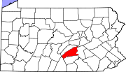
- Duncannon, Pennsylvania
-
Duncannon, Pennsylvania — Borough — Duncannon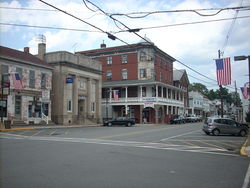

 Duncannon, Pennsylvania
Coordinates: 40°23′38″N 77°01′14″W / 40.39389°N 77.02056°WCoordinates: 40°23′38″N 77°01′14″W / 40.39389°N 77.02056°W Country United States State Pennsylvania County Perry Settled 1792 Incorporated 1844 Area – Total 0.4 sq mi (1.1 km2) Elevation 358 ft (109 m) Population (2000) – Total 1,508 – Density 3,566.5/sq mi (1,386.3/km2) Time zone Eastern (EST) (UTC-5) – Summer (DST) EDT (UTC-4) Zip code 17020 Area code(s) 717 Website Borough's website Duncannon is a borough in Perry County, Pennsylvania, United States. The population was 1,508 at the 2000 census. It is part of the Harrisburg–Carlisle Metropolitan Statistical Area. The center of population of Pennsylvania is located in Duncannon.[1] It is named after the coastal town of Duncannon, County Wexford, Ireland.[citation needed] Lightning Guider sleds were manufactured in Duncannon from 1904 until 1988.[2] The Appalachian Trail runs along Market Street, the main street in Duncannon.
Geography
Duncannon is located at 40°23′38″N 77°1′44″W / 40.39389°N 77.02889°W (40.393986, -77.028891)[3].
According to the United States Census Bureau, the borough has a total area of 0.4 square miles (1.0 km2), all of it land.
Demographics
As of the census[4] of 2000, there were 1,508 people, 667 households, and 386 families residing in the borough. The population density was 3,566.5 people per square mile (1,386.3/km²). There were 714 housing units at an average density of 1,688.7 per square mile (656.4/km²). The racial makeup of the borough was 98.28% White, 0.53% African American, 0.07% Asian, 0.73% from other races, and 0.40% from two or more races. Hispanic or Latino of any race were 1.59% of the population.
There were 667 households out of which 25.8% had children under the age of 18 living with them, 41.8% were married couples living together, 12.3% had a female householder with no husband present, and 42.1% were non-families. 36.1% of all households were made up of individuals and 16.8% had someone living alone who was 65 years of age or older. The average household size was 2.26 and the average family size was 2.94.
In the borough the population was spread out with 23.1% under the age of 18, 9.6% from 18 to 24, 28.7% from 25 to 44, 20.3% from 45 to 64, and 18.3% who were 65 years of age or older. The median age was 38 years. For every 100 females there were 91.1 males. For every 100 females age 18 and over, there were 85.3 males.
The median income for a household in the borough was $33,000, and the median income for a family was $38,750. Males had a median income of $31,643 versus $21,477 for females. The per capita income for the borough was $15,883. About 6.2% of families and 8.5% of the population were below the poverty line, including 8.0% of those under age 18 and 8.2% of those age 65 or over.
References
- ^ State Population Centers United States Census Bureau
- ^ Old Sled Works History Accessed April 25, 2010.
- ^ "US Gazetteer files: 2010, 2000, and 1990". United States Census Bureau. 2011-02-12. http://www.census.gov/geo/www/gazetteer/gazette.html. Retrieved 2011-04-23.
- ^ "American FactFinder". United States Census Bureau. http://factfinder.census.gov. Retrieved 2008-01-31.
Municipalities and communities of Perry County, Pennsylvania Boroughs Blain | Bloomfield | Duncannon | Landisburg | Liverpool | Marysville | Millerstown | New Buffalo | Newport
Townships Unincorporated
communitiesCove | Ickesburg | Perdix | Shermans Dale
Categories:- Populated places on the Susquehanna River
- Populated places established in 1792
- Harrisburg metropolitan area
- Boroughs in Perry County, Pennsylvania


Wikimedia Foundation. 2010.