California State Route 154
- California State Route 154
Infobox road
state=CA
type=SR
route=154
section=454
maint=Caltrans
length_mi=32.30
length_round=2
length_ref= [ [http://www.dot.ca.gov/hq/structur/strmaint/brlog2.htm January 1, 2006 California Log of Bridges on State Highways] ]
direction_a=West
terminus_a=jct|state=CA|US|101 near Los Olivos
direction_b=East
terminus_b=jct|state=CA|US|101 in Santa Barbara
previous_type=SR
previous_route=153
next_type=SR
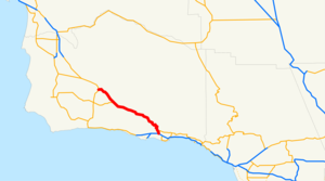
next_route=155State Route 154 (also known as the Chumash Highway [ [http://www.leginfo.ca.gov/pub/07-08/bill/asm/ab_0051-0100/acr_75_bill_20070823_introduced.pdf ACR 75] ] or unofficially as San Marcos Pass after the signage) runs from Los Olivos to Santa Barbara, California, USA. Before U.S. Route 101 was built, this was the main throughway to Santa Barbara and the tri city area. It is a 2 lane road with some passing lanes. It rivals US 101 for traffic, but it goes through the Los Padres National Forest and the San Marcos Pass. It starts in Los Olivos as a spur from US 101, goes through the town, and then passes Santa Ynez. It then reaches Lake Cachuma and passes through the Los Padres National Forest, across the Cold Spring Canyon Arch Bridge and the San Marcos Pass before descending to Santa Barbara. It then passes Cathedral Oaks before ending at US 101 near Calle Real.
This route is part of the California Freeway and Expressway System[ [http://www.leginfo.ca.gov/cgi-bin/displaycode?section=shc&group=00001-01000&file=250-257 CA Codes (shc:250-257)] ] and is eligible for the State Scenic Highway System][ [http://www.leginfo.ca.gov/cgi-bin/displaycode?section=shc&group=00001-01000&file=260-284 CA Codes (shc:260-284)] ] .]
ee also
*San Marcos Pass
References
External links
* [http://www.dot.ca.gov/hq/LandArch/scenic_highways/route154.htm Caltrans: Route 154 - Scenic Highway]
* [http://www.cahighways.org/153-160.html#154 California Highways: Route 154]
Wikimedia Foundation.
2010.
Look at other dictionaries:
California State Route 1 — For other uses, see CA1 (disambiguation). State Route 1 Route information … Wikipedia
California State Route 192 — Infobox road state=CA type=SR route=192 section=492 maint=Caltrans length mi=21 length round=0 length ref= [ [http://www.dot.ca.gov/hq/structur/strmaint/brlog2.htm January 1, 2006 California Log of Bridges on State Highways] ] direction a=West… … Wikipedia
California State Route 246 — Infobox road state=CA type=SR route=246 section=546 maint=Caltrans length mi=26 length round=0 length ref= [ [http://www.dot.ca.gov/hq/structur/strmaint/brlog2.htm January 1, 2006 California Log of Bridges on State Highways] ] direction a=West… … Wikipedia
California State Route 150 — Infobox road state=CA type=SR route=150 section=450 maint=Caltrans length mi=36 length round=0 length ref= [ [http://www.dot.ca.gov/hq/structur/strmaint/brlog2.htm January 1, 2006 California Log of Bridges on State Highways] ] direction a=West… … Wikipedia
California State Route 166 — State Route 166 Maricopa Highway … Wikipedia
California State Route 153 — Infobox road state=CA type=SR route=153 section=453 maint= length mi=0.550 length round=3 length ref= direction a=West terminus a=Marshall s Monument direction b=East terminus b=jct|state=CA|SR|49 at Coloma previous type=SR previous route=152… … Wikipedia
California State Route 155 — Infobox road state=CA type=SR route=155 section=455 maint=Caltrans length mi=74.79 length round=2 length ref= [http://www.dot.ca.gov/hq/structur/strmaint/brlog2.htm January 1, 2006 California Log of Bridges on State Highways] ] established=… … Wikipedia
Utah State Route 30 — Infobox road state=UT type=SR route=30 alternate name=Bear Lake Scenic Byway Valley View Highway section=108 maint= length mi=135.620 length round=3 length ref=cite web url=http://www.dot.utah.gov/main/uconowner.gf?n=7043101423294856 title=Route… … Wikipedia
State Scenic Highway System (California) — infobox road state=CA marker highway name=State Scenic Highway SystemThe State Scenic Highway System is a list of highways, mainly state highways, that have been designated by the California Department of Transportation (Caltrans) as scenic… … Wikipedia
California Freeway and Expressway System — The California Freeway and Expressway System is a system of existing or planned freeways and expressways in the U.S. state of California. It is defined by the Streets and Highways Code.List of roads in the system*State Route 1 (part) *State Route … Wikipedia
