- CanAm Highway
Infobox road
marker_
state=
highway_name=CanAm Highway
name_notes=Saskatchewan map of Canadian portionUnited States map below of US portion
route=
alternate_name=
maint=
section=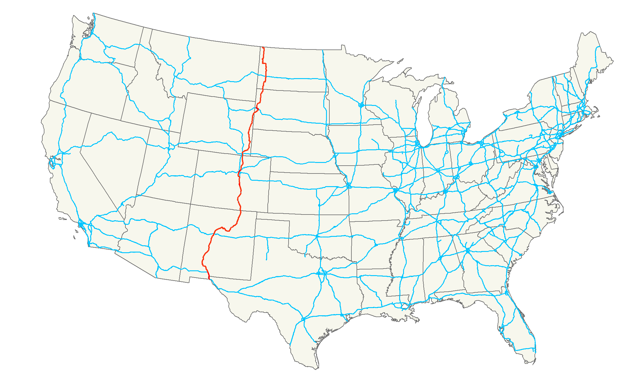
length_mi=2561.6
length_round=
length_ref=
length_notes=
established=
decommissioned=
direction_a=South
terminus_a=El Paso, TX at Mexican Border
(to )
beltway_city=
junction=
direction_b=North
terminus_b=La Ronge, SK CA at SK 102
counties=
rural_municipalities=
cities=El Paso, Texas ,Albuquerque, New Mexico ,Pueblo, Colorado ,Colorado Springs, Colorado ,Denver, Colorado ,Greeley, Colorado ,Cheyenne, Wyoming ,Spearfish, South Dakota ,Belle Fourche, South Dakota ,Williston, North Dakota , Regina, SK, Weyburn, SK, Prince Albert, SK
system=U.S. Route 85 , SK 35, Sk 39, Sk 6, Sk 3, Sk 2 [cite web
authorlink =
coauthors =
title =CanAm Highway - Tourism Saskatchewan
work =
publisher =
date =
url = http://www.sasktourism.com/places-to-go/road-trips/canam-highway
format =
doi =
accessdate = 2008-02-17]
spur_type=
spur_of=
previous_type=highway
previous_route=Mexican Federal Highway 45
next_type=highway
next_route=SK 102
browse=
commons=
customcommons=CanAm Highway passes through these
state s in theUnited States ;Texas ,New Mexico ,Colorado ,Wyoming ,South Dakota ,North Dakota , as well as theprovince ofSaskatchewan ,Canada . [cite web
last = Macdonald
first = Julian
authorlink =
coauthors =
title = Provincial Highways @ Saskatchewan Highways Website
work =
publisher =
date = 1999-2003
url = http://saskhighways.homestead.com/provincial.html
format =
doi =
accessdate = 2008-02-17] The international Can-Am Highway travels alongU.S. Route 85 connectingMexico toCanada through theUnited States . The CanAm highway in Canada comprises Saskatchewan Highways SK 35, Sk 39, Sk 6, Sk 3, and Sk 2 [cite web
authorlink =
coauthors =
title =Western Canada Group Travel Planner: Getting to Western Canada
work =
publisher =
date = 1999-2003
url = http://www.grouptravelplanner.net/WesternCanada/GettingHere/
format =
doi =
accessdate = 2008-02-17] . The route continues south in Mexico asMexican Federal Highway 45 , and north as SK 102 but are not labeled the CanAm highway.History
North American Free Trade Agreement NAFTA super corridors are a concept of huge transportation corridors connecting Mexico, United States, and Canada. The CanAm highway was a concept begun in the 1920s. Quotation|The CanAm matters so little to Saskatchewan highway planners that they've turned the most southern part of it within the province -- the Highway 35 link from Weyburn to the little U.S. border crossing at Oungre -- to gravel.|cite web
last =
first =
authorlink =
coauthors =
title = 'Super corridor' theories simply updated old idea
work =
publisher = The StarPhoenix
date = Tuesday, August 28, 2007
url = http://www.canada.com/saskatoonstarphoenix/news/forum/story.html?id=5db32cc0-13b7-45b0-90ad-7f64d62db6f7&p=1
format =
doi =
accessdate = 2008-04-15]Highway Links
Jcttop|length_ref=cite map
publisher = Microsoft Corporation Redmond Washington
title = Microsoft Streets and Tips
url =
edition = 2004
section =
accessdate = 2008-02-10] Jctint
county_special=
location_special= El Paso, TX
mile=mi to km|num=0|abbr=no|spell=Commonwealth|precision=2|wiki=yes
road=U.S. Route 85
notes=Southern Terminus at Mexican Border Travel north continues onU.S. Route 85 Jctint
county_special=
location_special=
mile=mi to km|num=2031.7|abbr=no|spell=Commonwealth|precision=2|wiki=yes
road=U.S. Route 85
notes=Border ofUnited States andCanada . Travel north continues on SK 35Jctint
county_special=
location_special= Port of Oungre
mile=mi to km|num=2041.8|abbr=no|spell=Commonwealth|precision=2|wiki=yes
road=SK 18
notes=Travel north continues on SK 35Jctint
county_special=
location_special= Weyburn
mile=mi to km|num=2078.2|abbr=no|spell=Commonwealth|precision=2|wiki=yes
road=SK 39
notes=Travel north continues on SK 39Jctint
type=concur
county_special=
location_special=
mile=mi to km|num=2120.2|abbr=no|spell=Commonwealth|precision=2|wiki=yes
road=SK 6
notes=Concurrency begins SK 39 - SK 6 mi to km|num=2.3|abbr=no|spell=Commonwealth|precision=2|wiki=yes . Jctint
type=concur
county_special=
location_special=Corinne
mile=mi to km|num=2122.5|abbr=no|spell=Commonwealth|precision=2|wiki=yes
road=SK 6
notes=Concurrency ends SK 39 - SK 6. Travel north continues on SK 6Jctint
county_special=
location_special= Melfort
mile=mi to km|num=2325.6|abbr=no|spell=Commonwealth|precision=2|wiki=yes
road=SK 3
notes=Travel north continues on SK 3Jctint
county_special=
location_special= Prince Albert
mile=mi to km|num=2385.3|abbr=no|spell=Commonwealth|precision=2|wiki=yes
road=SK 2
notes=Travel north continues on SK 2Jctint
type=concur
county_special=
location_special= Weyakwin
mile=mi to km|num=2475.1|abbr=no|spell=Commonwealth|precision=2|wiki=yes
road=SK 165
notes=Concurrency begins SK 165 - SK 2 mi to km|num=25.3|abbr=no|spell=Commonwealth|precision=2|wiki=yes. Travel north continues on SK 2Jctint
type=concur
county_special=
location_special=
mile=mi to km|num=2514.1|abbr=no|spell=Commonwealth|precision=2|wiki=yes
road=SK 969
notes=Concurrency ends SK 165 - SK 2 at the intersection with SK 969. Travel north continues on SK 2Jctint
county_special=
location_special= La Ronge
mile=mi to km|num=2561.6|abbr=no|spell=Commonwealth|precision=2|wiki=yes
road=SK 2
notes=Northern Terminus. Travel north continues on SK 102 but not as the CanAmee also
*
U.S. Route 85
*SK 35
*Sk 39
*Sk 6
*Sk 3
*Sk 2References
External links
* [http://saskhighways.homestead.com/provincial.html Saskatchewan Highways Website]
Wikimedia Foundation. 2010.