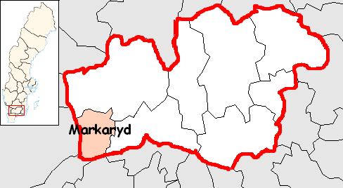
- Markaryd Municipality
-
Markaryd Municipality
Markaryds kommun— Municipality — 
Coat of arms
Country Sweden County Kronoberg County Seat Markaryd Area[1] - Total 535.63 km2 (206.8 sq mi) - Land 520.2 km2 (200.9 sq mi) - Water 15.43 km2 (6 sq mi) Area as of January 1, 2010. Population (June 30, 2010)[2] - Total 9,608 - Density 17.9/km2 (46.5/sq mi) Time zone CET (UTC+1) - Summer (DST) CEST (UTC+2) Postal code ISO 3166 code SE Province Småland Municipal code 0767 Website www.markaryd.se Markaryd Municipality (Markaryds kommun) is a municipality in south-west Kronoberg County in southern Sweden, where the town Markaryd is seat.
In 1916 a part of the rural municipality of Markaryd was detached from it, forming a market town (köping) with the same name. The two entities were reunited in 1960. The present municipality was created in 1971, when Traryd and Markaryd were amalgamated.
The nature is mainly dominated by forests, as usually in Småland, but there are also significant agricultural areas. Stretching from the northern to the southern parts is the river Lagan, making up the foundation of the water system with opportunities for fishing, canoeing and camping. There are also specific areas created for walks in forest and wildlife nature, and just east of the town Markaryd is a possibility for moose safari, arranged by Smalandet.
The European route E4 motorway goes just by the town of Markaryd and also the other town Strömsnäsbruk.
Localities
There are 4 urban areas (also called a tätort or locality) in Markaryd Municipality.
In the table the localities are listed according to the size of the population as of 31 December 2005. The municipal seat is in bold characters.
# Locality Population 1 Markaryd 3,826 2 Strömsnäsbruk 2,006 3 Traryd 687 4 Timsfors 609 References
- ^ "Statistiska centralbyrån den 1 januari 2010" (in Swedish) (Microsoft Excel). Statistics Sweden. http://www.scb.se/Statistik/MI/MI0802/2010A01/mi0802tab3_2010.xls. Retrieved 2010-08-21.
- ^ "SCB, Befolkningsstatistik 30 juni 2010" (in Swedish). Statistics Sweden. http://www.scb.se/Pages/TableAndChart____244147.aspx. Retrieved 2010-08-19.
External links
- Markaryd Municipality - Official site
- Smalandet
- Coat of arms
Municipalities 
Municipal seats Localities in Markaryd Municipality, Kronoberg County, Sweden Localities: Categories:- Municipalities of Sweden
- Municipalities of Kronoberg County

Wikimedia Foundation. 2010.