- Petroleum Road
-
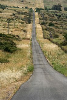
The Petroleum Road (Hebrew: כביש הנפט, Kvish HaNeft) is a privately owned north-south asphalt road in the Golan Heights. It is 47 km (29 mi) long. It begins near Mount Paras on the east edge of the central Golan, and ends in the northern Golan near the Israeli controlled Golan-Lebanese frontier, nearby Ghajar.
Most of the road is marked on maps as inaccessible to traffic because of poor road quality.[1]
The name Petroleum Road derives from the now defunct oil pipeline of the Trans-Arabian Pipeline Company, which the road runs adjacent to. The Tapline, as it is abbreviated, originated in the oil fields of Saudi Arabia, then proceeded through Jordan and Syria until reaching its oil export terminal in Sidon on the coast of Lebanon. Even though Israel came to control the section of the Tapline through the Golan after the 1967 Six-Day War it permitted its operation to continue. However, although it was the largest pipeline system in the world when it was completed in 1950, the Tapline had ceased all operations by 1990. The Golan Heights section stopped transporting petroleum in 1976.
Since the road diagonally bisects the entire length of the northern portion of the Golan Heights, it was the site of many battles fought along its axis during the Yom Kippur War in 1973.
Contents
The road
The length of the road that accompanies the pipeline in the Golan Heights is 45 km (28 mi). The southernmost 2 km were destroyed when Israel constructed its forward line of defensive fortifications opposite the ceasefire line between Israel and Syria after the Six-Day War. In addition, the northernmost 4 km is generally not considered part of the Petroleum Road, but is rather part of Route 999.
Since the Petroleum Road is a private road, not maintained by the Israeli transport authority, it has not been assigned a number.
Intersections on the route
Kilometers Name Location Intersecting routes Petroleum Road (from south to north) 0 צומת אורחה
(Orha Junction)Yonatan (moshav)  Highway 98
8 צומת קשת
(Keshet Junction)Keshet  Highway 87
17 צומת ללא שם
(Nameless Junction)Ortal  Highway 91
26 צומת רוויה
(Revaya Junction)Kela Alon Route 959 41 צומת בניאס
(Banyas Junction)Banias  Highway 99
45 גבול לבנון
(Lebanese Border)Ghajar Places of interest on the route
- Mount Paras
- Keshet Yehonatan Field School in Keshet
- Memorial monument for the IDF 188th Brigade
- Orvim creek nature reserve
- A view of Tel Faher, where the Golani Brigade fought a battle
- Banias archaeological site
See also
References
- ^ The Hebrew guide מדריך כרטא, (Madrikh Karta), by Azaria Alon, ISBN 965-220-528-1, uses the term כביש משובש ("broken road") for the entire route. Another map, published by Mapa (http://www.mapa.co.il) in 2001, uses a similar term for the portion between Highway 91 and Route 959.
External links
Coordinates: 33°0′54.77″N 35°45′56.95″E / 33.0152139°N 35.7658194°E
Categories:- Golan Heights
- Roads in Israeli-occupied territories
Wikimedia Foundation. 2010.

